Download
1 / 50
500 likes | 913 Views
Climate and Terrestrial Biodiversity. Chapter 7 Miller and Spoolman (2010). Core Case Study: Connections between Wind, Climate, and Biomes. Why are some areas of earth’s land surface covered by desert, another by grassland, and another by forest?

E N D
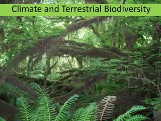
Climate and Terrestrial Biodiversity Chapter 7 Miller and Spoolman (2010)
Core Case Study: Connections between Wind, Climate, and Biomes • Why are some areas of earth’s land surface covered by desert, another by grassland, and another by forest? • Climate – long-term differences in average temperature and precipitation caused by global air circulation. • Wind • Indirect form of solar energy • Circulatory system for heat, moisture, plant nutrients, soil particles, and long-lived air pollutants. • Wind as a transport of nutrients • Carries dust rich in Pi and Fe across the Atlantic Ocean from the Sahara Desert. • build ag-soils in Bahamas and rainforests in Brazil • From China’s Gobi Desert deposits Fe into the Pacific between Hawaii and Alaska. • Stimulates growth of phytoplankton—base of ocean food webs.
Downside of wind • Transports harmful pollutants • From Africa’s deserts • Reddish brown soil and pesticides (banned in U.S.) to sky of Florida • Some types of Fungi in dust may degrade coral in FL Keys and Caribbean • Fe-rich dust enhances productivity of toxic algal blooms—called red tide • From rapidly industrializing China and c. Asia • Degrades air quality in western U.S. • 10% of w. coast smog • May intensify heat trapping by atmosphere • Ecological lesson: Everything we do affects some other part of the biosphere because everything is connected.
Figure 7.1Some of the dust blown from West Africa, shown here, can end up as soil nutrients in Amazonian rain forests and toxic air pollutants in the U.S. state of Florida and in the Caribbean. It may also help to suppress hurricanes in the western Atlantic.
7-1 What Factors Influence Climate? • Concept 7-1 An area's climate is determined mostly by solar radiation, the earth’s rotation, global patterns of air and water movement, gases in the atmosphere, and the earth’s surface features.
The Earth Has Many Different Climates • Weather – is local area’s short-term temperature, precipitation, humidity, wind speed, cloud cover, and other physical conditions in the atmosphere as measure over days and hours. • Climate – is an area’s general pattern of atmosphere or weather conditions over long periods of time ranging from decades to thousands of years. • Varies in different parts of the earth because patterns in global air circulation and ocean currents distribute heat unevenly.
Three major factors determine how air circulates in lower atmosphere: • Uneven heating of earth’s surface by the sun. • Rotation of the earth on its axis (Figure 7.3) • Coriolis effect • Cells • Prevailing winds – major surface winds that blow continuously and help distribute air, heat, and dust over the earth’s surface. • Properties of air, water, and land (Figure 7.4) • Convection • Heat from sun creates giant cyclical convection cells • Circulates air, heat, and moisture
Figure 7.2Natural capital: generalized map of the earth’s current climate zones, showing the major contributing ocean currents and drifts and upwelling areas (where currents bring nutrients from the ocean bottom to the surface). Winds play an important role in distributing heat and moisture in the atmosphere, which leads to such climate zones. Winds also cause currents that help distribute heat throughout the world’s oceans. Question: Based on this map what is the general type of climate where you live?
Figure 7.4Energy transfer by convection in the atmosphere. Convection occurs when hot and wet warm air rises, cools, and releases heat and moisture as precipitation (right side). Then the denser cool, dry air sinks, gets warmer, and picks up moisture as it flows across the earth’s surface to begin the cycle again.
Prevailing winds and the earth’s drive the earth’s major ocean currents (Figure 7.3) • Currents redistribute heat from the sun • Influences climate and vegetation, esp. near coastal areas. • Heat absorbed by oceans in tropical areas • Prevailing winds and irregularly shaped continents • currents flowing in roughly circular patterns • Clockwise in northern hemisphere • Counterclockwise in southern • More on heat transfer • Vertical mixing in deep and shallow ocean currents • Creates a loop of deep and shallow water currents • Like a giant conveyor belt • Moves heat to and from deep sea • Transfers warm and cold water between tropics and poles (Fig. 7.5)
Figure 7.5Connected deep and shallow ocean currents. A connected loop of shallow and deep ocean currents transports warm and cool water to various parts of the earth. This loop, which rises in some areas and falls in others, results when ocean water in the North Atlantic near Iceland is dense enough (because of its salt content and cold temperature) to sink to the ocean bottom, flow southward, and then move eastward to well up in the warmer Pacific. A shallower return current aided by winds then brings warmer, less salty—and thus less dense—water to the Atlantic. This water can cool and sink to begin this extremely slow cycle again. Question: How do you think this loop affects the climates of the coastal areas around it?
The ocean and the atmosphere are strongly linked in two ways. • Ocean currents are affected by winds. • Heat from the oceans affects the atmosphere • Example: The El Nino-Southern Oscillation • Occurs every few years when prevailing winds in the tropical Pacific Ocean weaken and change direction • above average warming of Pacific waters • changes distribution of nutrients (Fig. 6, Suppl. 8) • alters weather patterns of at least 2/3 of the earth for one to two years (Fig. 5, Suppl. 8)
Figure 6 Locations of flowing masses of warm water in the Pacific Ocean during El Nino.
Figure 5Typical global weather effects of an El Nino-Southern Oscillation
Figure 7.6Global air circulation, ocean currents, and biomes. Heat and moisture are distributed over the earth’s surface via six giant convection cells (like the one in Figure 7-4) at different latitudes. The resulting uneven distribution of heat and moisture over the planet’s surface leads to the forests, grasslands, and deserts that make up the earth’s terrestrial biomes. • Global air circulation patterns, prevailing winds, and configuration of continents and oceans • Six giant convection cells (Fig. 7.6) • 3 cells north of equator • 3 cells south of equator • ` Irregular distribution of climates and deserts, grasslands, and forests
Greenhouse Gases Warm the Lower Atmosphere • Figure 3.8, Energy flow to and from earth • Greenhouse gases play a role in determining the earth’s average temperatures. • Water vapor (H2O), carbon dioxide (CO2), methane (CH4), and nitrous oxide (N2O). • Absorb and re-radiate IR. • Greenhouse effect is the natural warming caused by ghg.
Figure 3.8Solar capital: flow of energy to and from the earth.
Human-enhanced global warming • Climate models: 90-99% probability that human activities are increasing ghe. • Burning fossil fuels, clearing forests, and growing crops • changes in climate that could last 100s to 1000s of years • Alters precipitation patterns • Shifts areas where crops can grow • Raises sea levels • Shifts habitats for some types of plants and animals
The Earth’s Surface Features Affect Local Climates • Heat is absorbed and released more slowly by water than by land. • Creates land and seas breezes • Moderates climate in coastal and lakeshore areas • Topography of earth’s surfaces • Creates local and regional weather and climates that differ the general climate from the region. • Example: Mountains, surface winds and the rain shadow effect • Cities create distinct microclimates • Bricks, concrete, and asphalt absorb heat • Buildings block wind • Motor vehicles and air conditioning units • haze and smog, higher temperatures and lower winds speeds
Figure 7.7The rain shadow effect is a reduction of rainfall and loss of moisture from the landscape on the side of a mountain facing away from prevailing surface winds. Warm, moist air in onshore winds loses most of its moisture as rain and snow on the windward slopes of a mountain range. This leads to semiarid and arid conditions on the leeward side of the mountain range and the land beyond. The Mojave Desert in the U.S. state of California and Asia’s Gobi Desert are both produced by this effect.
7-2 How Does Climate Affect the Nature and Locations of Biomes? • Concept 7-2 Differences in average annual precipitation and temperature lead to the formation of tropical, temperate, and cold deserts, grasslands, and forests, and largely determine their locations.
Climate Affects Where Organisms Can Live • Biomes – large terrestrial regions characterized by similar climate, soil, plants and animals, regardless of where they are found in the world. • The worlds major biomes vary with climate (compare Figs. 7.2 and 7.8.
Figure 7.8Natural capital: the earth’s major biomes—the main types of natural vegetation in various undisturbed land areas—result primarily from differences in climate. Each biome contains many ecosystems whose communities have adapted to differences in climate, soil, and other environmental factors.
Biomes are not uniform, but consist of a mosaic of patches each with somewhat different biological communities but with similarities typical of the biome. • resources are not evenly distributed • human activities • Climate and vegetation vary with latitude and elevation (Fig. 7.9) • Differences in climate, mostly annual precipitation and temperature lead to the formation of tropical (hot), temperate (moderate) and polar (cold) deserts, grasslands and forests (Fig. 7.10)
Figure 7.9Generalized effects of elevation (left) and latitude (right) on climate and biomes. Parallel changes in vegetation type occur when we travel from the equator to the poles or from lowlands to mountaintops. Question: How might the components of the left diagram change as the earth warms during this century? Explain.
Figure 7.10Natural capital: average precipitation and average temperature, acting together as limiting factors over a long time, help to determine the type of desert, grassland, or forest biome in a particular area. Although each actual situation is much more complex, this simplified diagram explains how climate helps to determine the types and amounts of natural vegetation found in an area left undisturbed by human activities.
Science Focus: Staying Alive in the Desert • Two main themes for survival in the desert: beat the heat and every drop of water counts. • Plant adaptations • Animal strategies and adaptations
There Are Three Major Types of Deserts • Deserts are characterized annual precipitation is low and scattered unevenly throughout the year. • Tropical deserts (examples: Sahara and Namib) • Temperate deserts (example: Mojave; Figure 1, Suppl. 9) • Cold deserts (example: Gobi in Mongolia) • Fragile ecosystem • Soils are slow to recover because of • Slow plant growth • Low species diversity • Slow nutrient recycling • Lack of water
Figure 7.11 Climate graphs showing typical variations in annual temperature (red) and precipitation (blue) in tropical, temperate, and cold deserts. Top photo: a popular (but destructive) SUV rodeo in United Arab Emirates (tropical desert). Center photo: saguaro cactus in the U.S. state of Arizona (temperate desert). Bottom photo: a Bactrian camel in Mongolia’s Gobi Desert (cold desert). Question: What month of the year has the highest temperature and the lowest rainfall for each of the three types of deserts?
Figure 1, Suppl. 9Some components and interactions in a temperate desert ecosystem.
There Are Three Major Types of Grasslands • Occur mostly in the interiors of continents and persist because of a combination of seasonal drought, grazing by large herbivores, and occasional fires. • Tropical, Temperate, and Cold (arctic tundra) • Tropical • Savanna • Resource partitioning • Grazing animals • Browsing animals • Plants adapted to survive heat and drought. • Temperate • Winters, bitterly cold; summers, hot and dry; annual rain, unevenly distributed • Deep fertile soils • many have disappeared • Two types • Tall-grass prairies • Short-grass prairies • Arctic tundra: fragile biome • Adaptations of plants and animals • Permafrost • GW and melting. • Alpine tundra
Figure 7.12 Climate graphs showing typical variations in annual temperature (red) and precipitation (blue) in tropical, temperate, and cold (arctic tundra) grassland. Top photo: wildebeests grazing on a savanna in Maasai Mara National Park in Kenya, Africa (tropical grassland). Center photo: wildflowers in bloom on a prairie near East Glacier Park in the U.S. state of Montana (temperate grassland). Bottom photo: arctic tundra (cold grassland) in autumn in front of the Alaska Range, Alaska (USA). Question: What month of the year has the highest temperature and the lowest rainfall for each of the three types of grassland?
Figure 2, Suppl. 9 Some components and interactions in a temperate tall-grass prairie ecosystem.
Figure 7.13Natural capital degradation: replacement of a biologically diverse temperate grassland with a monoculture crop in the U.S. state of California. When humans remove the tangled root network of natural grasses, the fertile topsoil becomes subject to severe wind erosion unless it is covered with some type of vegetation.
Figure 3, Suppl. 9Some components and interactions in an arctic tundra (cold grassland) ecosystem.
Temperate Shrubland: Nice Climate, Risky Place to Live • Temperate shrubland, or chaparral • Located in coastal regions that border on deserts. • Southern CA, USA; the Mediterranean; central Chile; southern Australia; and southwestern South Africa. • Closeness to sea provides slightly longer winter rainy season; and fogs during spring and fall reduce evaporation. • But, long, warm, dry summers • Vegetation • Low growing evergreen shrubs and small trees with leathery leaves. • Adapted for fires • Animals: mule deer, chipmunks, jackrabbits, lizards, and variety of birds. • Near the sea: nice climate • Prone to fires in the dry season followed by mudslides on rainy season.
Figure 7.14Chaparral vegetation in the U.S. state of Utah and a typical climate graph.
There Are Three Major Types of Forests • Tropical, Temperate, Cold (northern coniferous and boreal) • Tropical rain forests • Year-round uniformly warm temperatures, high humidity, and heavy rainfall almost daily. • Dominated by broadleaf evergreen plants. • Stratification of specialized plant and animal niches • Light levels canopy to ground • Vines (called lianas) • High NPP • High species diversity (2% of earth’s surface but at least half the terrestrial species • Because of dense vegetation, little wind • Significance? • Rapid recycling of scarce soil nutrients • 90% of nutrients released by decomposers is rapidly taken up by plants. • Impact of human activities • At least half destroyed by humans
Figure 7.16Some components and interactions in a tropical rain forest ecosystem. When these organisms die, decomposers break down their organic matter into minerals that plants use. Colored arrows indicate transfers of matter and energy between producers; primary consumers (herbivores); secondary, or higher-level, consumers (carnivores); and decomposers.
Figure 7.17Stratification of specialized plant and animal niches in a tropical rain forest. Filling such specialized niches enables species to avoid or minimize competition for resources and results in the coexistence of a great variety of species.
Temperate deciduous forests • Moderate average temperatures that change significantly with season. • Long, warm summers; cold but not too severe winters, and abundant precipitation, often spread evenly throughout the year. • Dominated by few species of broad-leaf deciduous tree such as oak, hickory, maple, poplar, and beech. • Survive cold winter by dropping leaves • Spring, grow leaves whose colors change in the fall • Slow decomposition rate accumulation of leaf litter, a storehouse of nutrients. • On global basis, most human disturbed terrestrial biome • Fauna • In eastern USA, once home to large predators: bears, wolves, foxes, wildcats, and mountain lions • Today most predators have been killed; dominant mammals now: white-tailed deer, squirrels, rabbits, opossums, raccoons, and mice • Migratory bird and their decline habitat destruction and fragmentation
Figure 4, Suppl. 9Some components and interaction in a temperate deciduous forest ecosystem.
Evergreen coniferous forests, or boreal forests, or taigas • Located just south of arctic tundra • Subarctic climate • Winters are long, dry, and extremely cold; sunlight only 6-8 hours per day • Summers, short, cool to warm and sun shines up to 19 hours per day • Dominated by coniferous evergreen trees (example: spruce, fir, cedar, hemlock, and pine • Plant adaptations to climate • Fauna • Bears, wolves, moose, lynx, and burrowing rodents • Caribou spend winter • Migratory birds such as warblers breed here
Figure 5, Suppl. 9Some components and interactions in an evergreen coniferous (boreal or taiga) forest ecosystem.
Coastal coniferous forests, or temperate rainforests • Scattered in coastal temperate areas with ample rainfall or moisture from dense fogs • Dense stands of spruce, Douglas fir, and redwoods once dominated undisturbed areas along the coast of North America Figure 7.18 Temperate rain forest in Olympic National Park in the U.S. state of Washington.
Figure 7.15Climate graphs showing typical variations in annual temperature (red) and precipitation (blue) in tropical, temperate, and cold (northern coniferous and boreal) forests. Top photo: the closed canopy of a tropical rain forest in the western Congo Basin of Gabon, Africa. Middle photo: a temperate deciduous forest in the U.S. state of Rhode Island during the fall. (Photo 4 in the Detailed Contents shows this same area of forest during winter.) Bottom photo: a northern coniferous forest in the Malheur National Forest and Strawberry Mountain Wilderness in the U.S. state of Oregon. Question: What month of the year has the highest temperature and the lowest rainfall for each of the three types of forest?
Mountains Play Important Ecological Roles • Highlands cover ¼ of earth’s land surface • Dramatic shifts in altitude, slope, climate, and vegetation take place over short distances. • 1.2 billion people live in mountain ranges • Major storehouses of water • Role in hydrologic cycle • 4 billion depend on them for water. • Steep slope means soil is easily eroded with natural and human disturbances. • Islands of biodiversity surrounded by a sea of human transformed landscapes. • Majority of the world’s forests • Habitats for endemic species • Help regulate the earth’s climate • Can affect sea levels • Major storehouses of water • Role in hydrologic cycle
7-3 How Have We Affected the Word’s Terrestrial Ecosystems? • Concept 7-3 In many areas, human activities are impairing ecological and economic services provided by the earth’s deserts, grasslands, forests, and mountains.
Humans Have Disturbed Most of the Earth’s Lands • According to the 2005 Millennium Ecosystem Assessment, 62% of the world’s major terrestrial ecosystems are being degraded or used unsustainably. • A major question of interest: How long can we keep eating away at these terrestrial forms of natural capital w/o threatening our economies and long-term survival of our own species? • Protection of remaining wild areas • Restoration of degraded and destroyed natural areas • The balance between exploitation and conservation is highly controversial.
Figure 7.20Major human impacts on the world’s deserts, grasslands, forests, and mountains. Question: Which two of the impacts on each of these biomes do you think are the most harmful?