Download
1 / 1
20 likes | 340 Views
Assessment of the Impacts of Climate and Land Cover Change on Landslide Susceptibility Muhammad Barik and Jennifer Adam Washington State University, Department of Civil & Environmental Engineering, Pullman, WA.

E N D
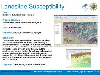
Assessment of the Impacts of Climate and Land Cover Change on Landslide Susceptibility Muhammad Barik and Jennifer Adam Washington State University, Department of Civil & Environmental Engineering, Pullman, WA. ABSTRACT: The Olympic Experimental State Forest (OESF) is a commercial forest lying between the Pacific coast and the Olympic Mountains. As this area is critical habitat for numerous organisms, including salmon, there is a need to investigate potential management plans to promote the economic viability of timber extraction while protecting the natural habitat, particularly in riparian areas. As clear-cutting reduces the strength of the soil, and as projected climate change may result in storms with higher intensity precipitation, this area may become more susceptible to landslide activity. This may result in potentially severe consequences to riparian habitat due to increased sediment loads. Therefore, this study was performed with an objective to quantify the impacts of land cover and climate changes on slope stability. A physically-based hydrology model, the Distributed Hydrology Soil Vegetation Model (DHSVM) with the sediment module, was used for this analysis. To find out areas susceptible for landslides, logging was done for different combinations of soil-vegetation and slope classes. This may help making management decisions to select harvesting with minimum impact on slope stability. To investigate the impacts of climate change on landslide susceptibility we applied two General Circulation Models (GCMs) and two greenhouse gas emission scenarios. 1 6 4 The Goal: The objective of this study is to determine the impacts of land-use management and climate change on landslide susceptibility over the OESF. To achieve this general objective the following specific objectives are set: • To determine the effect on land stability caused by different types of land-cover scenarios including historical vegetation conditions, conditions with widespread timber harvest, and conditions with varying amount of timber left. • To determine how future climate conditions will impact landslide susceptibility over the OESF. • Calibration: • For the calibration period (2001-2005), the Nash Sutcliffe coefficient is 0.62 while the volume error is 8%; and for the evaluation period (1995-1999) they are 0.58 and 11%, respectively. Effects of logging: • Figure shows response of landsliding with different logging scenarios. • The vegetation that was considered for logging, in this example, was Mesic Coniferous. • The DHSVM sediment module was run from • 1965 to 1989 for 20 storm events. 2 Study Domain: Figure: Observed and simulated stream flow between 2001 and 2004. Peak flows and dry season flows are underestimated by the model. • The study domain for this • research is the Queets basin, located on the Olympic Peninsula in northwest Washington State (see inset at top). • To run the mass sediment module of DHSVM a tributary of the Queets basin is selected (shown at left). 5 Selection of Logging Scenarios: • To simulatethe logging scenarios,two separate selection methods were followed. They are : • (1) Logging was applied to individual units with similar soils, vegetation, and slopes (see figure below). • (2) A varying percent timber extraction (25%,50%,75% and 100%) wasapplied to the entire basin. • Logging in steep slopes caused high • landslide frequencies. • Soil type has a significant effect on landslide susceptibility. • Landslide frequency varies linearly with percent area logged. A landslide susceptibility map shows vulnerable areas. Effects of Climate Change: 7 • Projected climate change for 2045 was used with the same possibility between 1965 and 1989. • Outputs are from CGCM3.1_t47 and CNRM_cm3 GCM models for A1B and B1 emission scenarios. Landslides with different climate change scenarios where logging is done in loamy soil with the slope range 20-30 degree Landslides with different climate change scenarios without any logging Table: Queets river characteristics 3 Model Description: • Landslide frequency increases under 2045 projected climate but the rate is not significant. 8 Schematic diagram for DHSVM mass wasting module (Doten et al., 2006) • Conclusions: • We have presented an approach to quantify the effects of logging and future climate on landslide susceptibility, which can be developed as a decision-making tool for forest management. Findings from this analysis include: • Landslide frequency increases in logged areas (by up to five times). • Certain combinations of soil, vegetation, and slopes are more vulnerable for landsliding than others. • Mapping of susceptible landslide areas based on the study shows most of the vulnerable areas for landslides are close to the streams, with potentially negative consequences for the ecological health of the riparian areas. • There is an insignificant increase in landslide events due to 2045 projected climate change. • ACKNOWLEDGEMENTS: Funding for this project is being provided by the State of Washington Water Research Center (SWWRC). Figure: Slope, vegetation and soil classes on the mass wasting study basin. Right hand of the figure shows a logging scenario, selected where vegetation class is mesic coniferous, soil class is loam and slope is between 20 to 30 degrees. • Model: DHSVM (Wigmosta et al. 1994) with its mass wasting module (Doten etal.2006) • The key component for this study, the mass wasting module, is stochastic in nature.