Download

1 / 58
580 likes | 610 Views
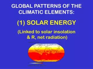
GLOBAL PATTERNS OF THE CLIMATIC ELEMENTS: (1) SOLAR ENERGY (Linked to solar insolation & R, net radiation). CONTROLS OF SOLAR INSOLATION 1) Sun angle (intensity) -- changes with latitude, time of day, time of year 2) Duration (day length) -- changes with latitude, time of year

E N D
GLOBAL PATTERNS OF THE CLIMATIC ELEMENTS:(1) SOLAR ENERGY (Linked to solar insolation & R, net radiation)
CONTROLS OF SOLAR INSOLATION 1) Sun angle (intensity) -- changes with latitude, time of day, time of year 2) Duration (day length) -- changes with latitude, time of year 3) Cloud cover (and general reflectivity of atmosphere) 4) Surface albedo (water, soil, snow, ice, vegetation, land use) In general, land areas (with lower atmospheric moisture) receive more insolation than adjacent water areas and the highest values occur over subtropical deserts.
RADIATION / ENERGY BALANCE Q* = ( K↓ - K↑ ) + ( L↓ - L↑ )where K↓ = direct + diffuse shortwave solar radiation
Radiative Components • Net short-wave radiation = short-wave down - short-wave up • Net long-wave radiation = long-wave down - long-wave up • Net radiation (R net) = net short-wave radiation + net long-wave radiation • Positive values represent energy moving towards the surface, negative values represent energy moving away from the surface.
Net short-wave radiation = Positive values represent energy moving towards the surface, negative values represent energy moving away from the surface.
SW absorbed = Function of INTENSITY & DURATION & sun angle / albedo
Net long-wave radiation = Positive values represent energy moving towards the surface, negative values represent energy moving away from the surface.
Net Surplus Net Deficit Net Deficit
Annual mean absorbed solar radiation, emitted longwave radiation (OLR) and net radiation by latitude
Net Radiation = Positive values represent energy moving towards the surface, negative values represent energy moving away from the surface.
Non-Radiative Components Sensible heat flux (H) = direct heating, a function of surface and air temperature Latent heat flux (LE) = energy that is stored in water vapor as it evaporates, a function of surface wetness and relative humidity Positive values for sensible and latent heat flux represent energy moving towards the atmosphere, negative values represent energy moving away from the atmosphere.
Non-Radiative Components Change in heat storage (G) = net radiation - latent heat flux - sensible heat flux G = R net - LE - H Positive values for change in heat storage represent energy moving out of storage, negative values represent energy moving into storage.
Sensible Heat Flux = H Positive values for sensible and latent heat flux represent energy moving towards the atmosphere, negative values represent energy moving away from the atmosphere.
Latent Heat Flux = LE Positive values for sensible and latent heat flux represent energy moving towards the atmosphere, negative values represent energy moving away from the atmosphere.
R net LE H R net H LE Humid Tropical / Equatorial rainforest Tropical desert
Tropical wet climate Tropical wet-dry climate Tropical desert climate Grassland /steppe climate
Change in Heat Storage = G Positive values for change in heat storage represent energy moving out of storage, negative values represent energy moving into storage.
Air Temperature (at the surface) = T (C) Seasonal temperature variations can be explained in terms of the latitudinal & seasonal variations in the surface energy balance. The pattern of temperatures are a function of net short-wave radiation, net long-wave radiation, sensible heat flux, latent heat flux and change in heat storage.
GLOBAL PATTERNS OF THE CLIMATIC ELEMENTS: (2) TEMPERATURE
CONTROLS OF HORIZONTAL TEMPERATURE PATTERNS • Sun angle & Duration • Land vs. water thermal contrasts • Warm & Cold surface ocean currents • Elevation • Ice/Snow albedo effects • Prevailing atmospheric circulation
1. Sun Angle & Duration • Sun angle (influences intensity of solar insolation & albedo) Duration (based on day length) - both change with latitude and time of year • Leads to: zonal (east-west) distribution of isotherms, hot in low latitudes; cold in high latitudes
2. Land vs. water thermal contrasts • Given the same intensity of insolation, the surface of any extensive deep body of water heats more slowly and cools more slowly than the surface of a large body of land. • 4 Reasons: • 1) water has a higher specific heat and heat capacity than land • 2) transmission of sunlight into transparent water • 3) mixing is possible in water, but not soil • 4) evaporation cools air over water during hot season (less evap during winter) • Leads to: • annual and diurnal temperature ranges will be less in coastal/marine locations • the lag time from maximum insolation to time of maximum temperature may be slightly longer in coastal/marine locations
6. Prevailing atmospheric circulation Temperatures are affected by the temperature "upwind" -- i.e. where the prevailing winds and air masses originate
MAPPING HORIZONTAL TEMPERATURE PATTERNS • Isotherms = lines connecting points of equal temperature • Isotherms will be almost parallel, extending east-west if Control #1 (sun angle) is the primary control. • If any of the other controls are operating, isotherms on a map will have an EQUATORWARD shift over COLD surfaces and a POLEWARD shift over WARM surfaces • The TEMPERATURE GRADIENT will be greatest where there is a rapid change of temperature from one place to another (closely spaced isotherms). • Continental surfaces in winter tend to have the steepest temperature gradients. • Temperature gradients are much smaller over oceans, no matter what the season.
JANUARY JULY Northern Hemisphere Southern Hemisphere
JANUARY JULY Northern Hemisphere Southern Hemisphere
http://geography.uoregon.edu/envchange/clim_animations/ Constructed by: Jacqueline J. Shinker, “JJ” Univ of Oregon Climate Lab