Download
1 / 22
220 likes | 349 Views
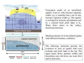
SR410 – White River Erosion Project Concept Modeling Ian Mostrenko (Herrera Environmental Consultants). Modeling of Current Conditions. Hydrologic Modeling Estimate peak river water flows Estimate timing, duration, and frequency Hydraulic Modeling Estimate water depths (flooding)

E N D
SR410 – White River Erosion ProjectConcept ModelingIan Mostrenko(Herrera Environmental Consultants)
Modeling of Current Conditions • Hydrologic Modeling • Estimate peak river water flows • Estimate timing, duration, and frequency • Hydraulic Modeling • Estimate water depths (flooding) • Estimate water speed (velocity) and erosive forces • Assess current flood and erosion hazards
White River Basin Mud Mt. Dam • Selection of an appropriate hydrologic model will depend on river basin characteristics Clearwater River Greenwater River West Fork White River Huckleberry Creek Mt. Rainier
Data for Hydrologic Modeling YEAR 1930 1940 1950 1960 1970 1980 1990 2000 2010 Calibration Rainfall Data Temperature Data Snow Pack Data Water Flow Data (White River) Water Flow Data (Greenwater River) Hydrologic Model Simulation
Hydrologic Modeling • Two models used: • HEC-HMS (developed by US Army Corps of Engineers) • DHSVM (developed by University of Washington)
Hydrologic Modeling LPIII Results:
Hydraulic Modeling General Model (HEC-RAS) • Set boundary conditions for 2-D Model Problem Site Model (FLO-2D) • Detailed model for each site • Assess localized effects
Reach-Scale Model Results Problem Site 9 (MP 41.4-42.0) Flooding across SR410
Site 9 – 100yr Water Depth FLOW SR 410 FLOW
Site 9 – 100yr Max Water Depth Nov 2006 Photo
Site 9 – November 2006 Photo Flooding High Water Velocity
Site 9 – Detailed Modeling for Design • Future Modeling Efforts: • HEC-RAS – refined using LIDAR to add mode detail for Site 9 (complete January 2008) • SHAL2D – detailed Finite Element model to refine design and assess sediment transport (complete February 2008)
Site 9 – Detailed Modeling for Design • HEC-RAS: