Download
1 / 31
310 likes | 437 Views
Status of operational NWP system and satellite data utilization at JMA. Masahiro KAZUMORI Numerical Prediction Division, Japan Meteorological Agency 1-3-4, Otemachi, Chiyoda-ku, Tokyo 100-8122, JAPAN kazumori@met.kishou.go.jp. Courtesy of H. Murata (MSC) and NPD colleagues.

E N D
Status of operational NWP system and satellite data utilization at JMA Masahiro KAZUMORI Numerical Prediction Division, Japan Meteorological Agency 1-3-4, Otemachi, Chiyoda-ku, Tokyo 100-8122, JAPAN kazumori@met.kishou.go.jp Courtesy of H. Murata (MSC) and NPD colleagues APSDEU-8 Montreal, Canada, October 10-12, 2007
Contents • Current NWP system at JMA • Recent developments • Plans for JFY2007 and after
Contents • Current NWP system at JMA • Recent developments • Plans for JFY2007 and after
NWP system at JMA 8th NWP system called NAPS-8
Numerical Analysis and Prediction System Kiyose 1st Building Kiyose 2nd Building JMA Headquarters
Supercomputers of JMA • HITACH SR11000(since Mar. 2006) • 2.1GFlops×16processors×80nodes×2=21.5TFlops • 1.9GFlops×16processors×50nodes×1=6.1TFlops • 13.1TB Main memory • 67TB Disk • 2PB Tape 80nodes 50nodes 80nodes HITACHI SR11000 -210nodes 27.6Tflops Main usage: 50 nodes(sub1 system) : Re-analysis and climate model 80 nodes(sub2 system) : Pre-operational model (20km Global model) 80 nodes(sub3 system) : Operational global and meso-scale model
Current Operational NWP Models • Mesoscale model(MSM) • Horizontal • Resolution: 5 km • Updates: 8 times a day • Regional model (RSM) • Horizontal • Resolution: 20 km • Updates: 2 times a day • Global model (GSM) • Horizontal • Resolution: 60 km • Updates: 4 times a day
Contents • Current NWP system at JMA • Recent developments • Plans for JFY2007 and after
Recent developments Oct. 2006 BUFR winds of GOES-11/12 and MTSAT-1R started to be used instead of SATOB winds. Feb. 2007 Assimilation of AP-RARS (Asia-Pacific Regional ATOVS Retransmission Service) data started. Mar. 2007 Assimilation of GPS-RO (Radio Occultation) data from CHAMP started. Apr. 2007 Assimilation of NOAA18/AMSU-A, MHS started. Jun. 2007 Direct assimilation of clear-sky radiances of water vapour channel from MTSAT-1R/IMAGER started. Aug. 2007 Assimilation of EARS (EUMETSAT Advanced Retransmission Service) ATOVS data started.
BUFR winds of GOES-11/12 and MTSAT-1R • Data assimilation of BUFR coded AMV data with QI (2006.10) • Improved thinning • Improved use of QI • Improved QC • Discontinue of Obs. Error adjustment • Use of MTSAT-1R hourly AMVs QI QI
Wind speed(Jan.2005, 300hPa, Right:Test,Left:Cntl) RMSE of Obs. against Guess Bias of Obs. against Guess Number of used data
Regional ATOVS Retransmission System (RARS) Network Configuration(as of August 2007) Beijing Seoul Urumuqi Kiyose (Tokyo) Guangzhou Singapore Darwin GTS circuits Crib Point 1 Crib Point 2 (Melbourne) Domestic links Perth HRPT receiving stations Syowa Station Modified by H. Murata
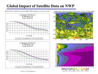
AP-RARS and EARS data Available data coverage AP-RARS (red) and EARS (blue) ATOVS data latency at JMA GTS (global data) EARS ATOVS (GTS route) RARS data is expected to bring positive impacts on early analysis and forecast at JMA. Cut off time of Meso-scale analysis Cut off time of global early analysis
without AP-RARS AP-RARS NWP Benefits Analysis difference (early - cycle) at 500hPa geopotential height with AP-RARS NOAA18 AMSUA NOAA15 AMSUA
without EARS EARS NWP Benefits Analysis difference (early - cycle) at 500hPa geopotential height with EARS NOAA18 AMSUA NOAA16 AMSUA NOAA15 AMSUA
GPS Radio Occultation data • Refractivity from CHAMP Low computational costs and effective method. n : Refractive index Forward --- Refractivity assimilation --- ●Distributed data ①Refractivityn1 ② Positionvectoratthetangentpoint ●Procedure of data assimilation ① Calculate the refractivity ( n2 ) at the tangent point using forward model from the first guess. ② Sum of n2-n1 and distance from the first guess was minimized from first guess using JMA global 4D-Var system. C1=77.6x10⁻⁶ C2=0.373 N : Refractivity TangentLinear Adjoint
GPS Radio Occultation data Data distribution of CHAMP Analysis increment by CHAMP Implemented in Operational DA system in Mar.2007 Assimilation of CHAMP refractivity showed small positive impact on forecast skill. Hope to see large impacts from COSMIC data.
NOAA-18/AMSU-A, MHS radiance data Expanded data coverage by NOAA-18 data in JMA global early analysis 4 AMSU-B (NOAA15,16,17,18) 4 AMSU-A (NOAA15,16,18,Aqua) 3 AMSU-B (NOAA15,16,17) 3 AMSU-A (NOAA15,16,Aqua) N.H. Z500 RMSE (Jan. 2007) N.H. Z500 RMSE (Aug. 2006) Red:W NOAA-18 Blue: W/O NOAA-18 Red:W NOAA-18 Blue: W/O NOAA-18 NOAA-18 data bring wide data coverage in the early analysis and better forecasts.
10 5 O-B map 0 -5 -10 MTSAT-1R CSR • Clear Sky Radiances (CSR) from MTSAT-1R WV channel • Meteorological Satellite Center (MSC) of JMA produces • ready for dissemination to NWP community. (Current user: ECMWF,CMC) clear ratio 00 UTC Sep.14 2006 O-B mean=-1.7std=2.18
MTSAT-1R CSR Typhoon track forecast verification • CSR provide moisture information in middle and upper troposphere. • Using CSR data together with polar-orbiting satellite data (AMSU-B) bring much moisture information around Japan. • Assimilation CSR data showed positive impact on typhoon forecast score. • Operational use started in 7 June 2007. Red:Without CSR Blue: With CSR Verification period: August 2006
Performance of GSM • NH Z500 (Day 2) • SH Z500 (Day 2) • NH Z500 (Day 5) • SH Z500 (Day 5)
Recent Operational Changes to MSM • Extended forecast time from 15 hours to 33hours (03, 09, 15, 21 UTC Initial) • Improvement of surface and boundary layer scheme, radiation scheme, cumulus parameterization scheme • Use of Non-hydrostatic model in 4D-Var outer loop forecast model(2007.5) Old-MSM New-MSM Observation Improvement of heavy rain forecasts.3-hour precipitation forecasts at 15hour forecasts from 21UTC 29 June, 2006 Initial. Old (left), New (center), Radar-AMeDAS observation (right)
Data use in Global Analysis (1/2) SYNOP BUOY SHIP RAOB PROFILER AIRCRAFT PAOB AMV
Data use in Global Analysis (2/2) SeaWinds AMSU-A AMSU-B SSMI TMI AMSR-E GPS-RO CSR
Data use in Mesoscale Analysis RAOB, Wind Profiler, Doppler radar SYNOP,SHIP, BUOY Air craft AMV, SeaWinds ATOVS retrievals Microwave radiometer (TPW, Rain rate)
Contents • Current NWP system at JMA • Recent developments • Plans for JFY2007 and after
NWP models at JMA in the near future (Late 2007-)
TL959L60 Global Model (20km-GSM) Comparison of New 20km-GSM and RSM (Regional model) Forecast score against initial Performance of the new 20km-GSM is superior to JMA Regional model (RSM 20km resolution). Parallel run of 20km-GSM started 26 Sep. 2007 and 20km-GSM will be implemented into operational system in Nov. 2007. Aug. and Sep. 2004 Dec. 2005 and Jan.2006
Plans for JFY2007 and after Nov. 2007 • Implementation 20km Global model • Typhoon Ensemble • 0.25 deg. SST analysis data for GA • Use of Metop ATOVS data for GA Mar. 2008 • MTSAT-1R hourly AMV for MA • GOES11/12 and Meteosat7,9 CSR data for GA • ASCAT: need level2 ocean surface wind data • AIRS radiance data for GA • SSMIS radiance data for GA • GRACE GPS-RO data for GA • Improved assimilation of scatterometer Ocean Vector Winds (ambiguity winds) • Non-hydrostatic based 4D-Var for MA After • New satellite data (IASI) and cloud/rain-affected radiances data • Radiance assimilation in MA Pre-operational run started in 26 Sep. 2007