Download

1 / 29
300 likes | 539 Views
APSDEU-7, Honolulu, 20-22 September 2006. Status of Operational NWP System and the Satellite Data Utilization at JMA. Yoshiaki Takeuchi Numerical Prediction Division Japan Meteorological Agency. Contents. 1. Current NWP system at JMA 2. Recent developments

E N D
APSDEU-7, Honolulu, 20-22 September 2006 Status of Operational NWP System and the Satellite Data Utilization at JMA Yoshiaki Takeuchi Numerical Prediction Division Japan Meteorological Agency
Contents 1. Current NWP system at JMA 2. Recent developments 3. Plans for JFY2006 and after
Domains of NWP models RSM (20km) GSM (60km) MSM (5km)
New Supercomputers of JMA Satellite Data Processing Numerical Weather Prediction Mar 2005- Mar 2006- • 13.1TB Main memory • 36.2TB Disk • 2.0PB Tape 50nodes 80nodes 80nodes HITACHI SR11000J1 50nodes HITACHI SR11000K1 160nodes 6.1Tflops 21.5Tflops =2.1 GFlops x 16 processors x 80 nodes x 2 =1.9 GFlops x 16 processors x 50 nodes x 1
Supercomputer (SR11000 K1 x 2 + SR11000 J1 x 1) Strage Area Network Servers of Divisions for Data Processing System and Job Information Acquisition Terminals Servers of Divisions for Data Processing Tape Library High-speed LAN High-speed LAN Servers for NWP Data Processing Servers for Satellite Data Processing Terminals for System Operation and Surveillance Weather Forecast Operation Aiding Server Numerical Analysis and Prediction System (NAPS-8 1 March 2006 - ) Objects 1. Satellite data processing 2. Numerical analysis and prediction Configuration of NAPS-8 KIYOSE Office (24km WNW from Tokyo) NAPS-WAN (100Mbps x2 Wide Area ether Network) Headquarters (Tokyo)
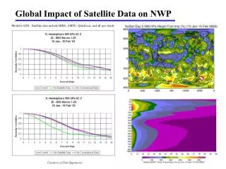
Performance of GSM (1) NH Z500 (Day 2) SH Z500 (Day 2) NH Z500 (Day 5) SH Z500 (Day 5)
Performance of GSM (2) WGNE intercomparison of typhoon track forecasts from operational global models 72 hour forecasts
Contents 1. Current NWP system at JMA 2. Recent developments 3. Plans for JFY2006 and after
Recent Operational Changes to GSM (1) ・A revised radiation scheme for better treatment of cloud effects and a new ozone climatology for the radiation calculations (2005.7) Old model New model AUG 2004 JAN 2005 Improvement of AC score of Z500 score in NH Red: New model Blue: Old model Reduction of zonal mean temperature error of 5-day forecasts.
Recent Operational Changes to GSM (2) ・A thinning scheme for one-hour time slots in 4D-Var for ATOVS assimilation (2005.8) Thinned by the old scheme but used with the new scheme Aqua/AMSU Obs. time NOAA-16/AMSU Assimilation window Improvement of typhoon track forecasts in August 2004 Red: New model, Blue: Old model Time
Recent Operational Changes to GSM (3) ・New operation at 06, 18 UTC with forecast time of 36 hours in addition to 00 UTC with 90 hours and 12 UTC with 216 hours. ・Increase in the resolution of inner loop of the 4D-Var from T63L40 (~200km) to T106L40 (~120km) (2006.3) NH SH T106L40 T106L40 T63L40 T63L40 Improvement of anomaly correlation coefficients (unit:%) of 500 hPa geopotential height forecasts in August 2004.
Improvement by 6 hours Recent Operational Changes to GSM (4) ・Direct assimilation of SSM/I, TMI, and AMSR-E radiance data (2006.5) ・Introduction of a variational bias correction for microwave sounder and imager data (2006.5) Improvement of typhoon track forecasts in August 2004 Red: with MWRs, Blue: without MWRs
Recent Operational Changes to GSM (5) ・Introduction of a variational bias correction for microwave sounder and imager data (2006.5) • Bias correction term is in the observation operator • Coefficients: b • Calculated in the system automatically Time developing data • It shows the relation between the instrument and model fields • Predictors: p • TCPW, • TSRF, • TSRF2, • WSSRF, • 1/cos(ZANG), • 1(Const) Observation Operator:
Recent Operational Change to MSM (1) ・Increase of radial wind data from two Doppler Radars for Airport Weather in the meso-analysis (2005.6) <http://www.tokyo-jma.go.jp /home/chubu/draw.htm> <http://www.morigumi.co.jp /works/kentiku.html> Coverage of Dopller Radar observation Blue: Additional sites (Fukuoka, Chubu), Green: Existing sites (Shin-Chitose, Narita, Tokyo, Osaka, Kansai, Naha)
Recent Operational Change to MSM (2) ・Increase in the resolution from 10kmL40 to 5kmL50. ・Enhanced operation from 4 times to 8 times a day. ・Shortened forecast time from 18 hours to 15 hours. ・Refinement of the radiation scheme, cumulus parameterization scheme, and surface and boundary layer schemes. (2006.3) Observation 10 km-MSM 5 km-MSM Improvement of heavy rain forecasts. One-hour precipitation forecasts at 00UTC 1 August 2004 with 5 km-MSM (center) and 10 km-MSM (right) and radar-AMeDAS observation (left)
Recent Operational Change to MSM (3) ・Introduction of a global daily sea surface temperature data analyzed by using data from satellite microwave radiometer, satellite infrared radiometer and in-situ observation (MGDSST) (2006.3) Note) MGDSST is also introduced to RSM and TYM (2006.3) • 0.25 x 0.25 degrees • Available for all weather condition New SST – Old SST at 26 MAY 2005 New SST Old SST Relative humidity at the lowest layer of MSM by 18 hours forecasts with 26 May 2005 initial time VIS imageat 00UTC 26 MAY 2005
Exchanged Direct Broadcast ATOVS Data Data coverage of NOAA-15,16,17 (AMSU-B ch.1) 00UTC 22 July 2006 Light: without RARS, Right: with RARS Data coverage of NOAA-18 by RARS (AMSU-A ch.4) 06UTC 23 July 2006
Exchanged direct broadcast ATOVS data Improvement of early analysis against cycle analysis by using AP-RARS. Coloured conter shows difference between early analysis and cycle analysis Z20 at 00 UTC 18 July 2006. Left: without AP-RARS, Right: with AP-RARS. Data coverage of AMSU-A ch.1 at 00UTC 18 July 2006
History of Satellite Data Ingest at JMA 7 August 2006 MTSAT/CSR ingest/ decode 18 July 2006 CHAMP data and GRACE data ingest / archive via Internet 16 July 2006 GOES-11, 12 CSBT ingest from NWS server via Internet 11 July 2006 ATOVS Syowa data recover 06 July 2006 NOAA-18 level 1C global data ingest from NWS server via Internet 20 June 2006 METEOSAT-8 AMV BUFR ingest via GTS 07 June 2006 RARS ATOVS data exchange via GTS 05 June 2006 CHAMP data ingest via Internet 25 May 2006 METEOSAT hourly AMV via Internet 09 May 2006 FY2 AMV data decode 06 April 2006 FY2 AMV data ingest 12 October 2005 NOAA-18 direct reception by MSC 05 July 2005 TBB-Albedo GPV data of MTSAT-1R instead of GOES-9 08 June 2005 GOES-10, 12 BUFR AMV via Internet 18 May 2005 Meteosat-5,7 CSR decode
History of Satellite Data Use at JMA 21 August 2006 ATOVS pre-processing update, Change of VarBC explaining variable for GA 15 August 2006 DMSP-15 SSM/I decode halted due to 22 GHz channel degradation 21 June 2006 Replace GOES-10 with GOES-11 for GA 14 June 2006 Meteosat-8 BUFR AMV use instead of Meteosat-7 for GA 15 May 2006 DMSP-13, 14, 15 /SSMI, Aqua/AMSR-E, TRMM/TMI radiance use for GA Variational Bias Correction is implemented and applied to MWR and ATOVS 18 April 2006 NOAA-18 temperature produced by NESDIS for MA 30 March 2006 NOAA-18 temperature produced by NESDIS for RA 02 August 2005 ATOVS thinning method improved with one-hour time slot for GA 21 July 2005 Aqua/AMSR-E radiance and TPW correction implemented for MA 15 July 2005 Replace GOES-9 SATOB with MTSAT-1R SATOB for GA, RA and MA
Contents 1. Current NWP system at JMA 2. Recent developments 3. Plans for JFY2006 and after
Plans for JFY2006 and after New Observation • AP-RARS for GSM (2006) • 0.25 deg. SST data based on AVHRR and MWR for GSM (May 2007) • EARS and extended AP-RARS for GSM (2007) • RARS for Metop (ATOVS, ASCAT) for GSM (2007) • MTSAT-1R hourly AMV for all models • Geostationary satellites WV data for GSM based on RTTOV-7 • Aqua/AIRS radiance data for GSM • GPS occultation data for GSM Analysis and Model • Improvement of resolution of 4D-Var inner model for GSM from T106 to T159 (May 2007) • Modification of physics for GSM (gravity wave drag, etc.) • a reduced grid for GSM with the resolution of 20km (May 2007) • 33 hours forecast ofMSM 4 times a day (May 2007) • Non-hydrostatic based 4D-Var for MA (March 2008) • Local Ensemble Transform Kalman Filter for GA and MA
Plan of the JMA NWP System JFY 2002 2003 2004 2005 2006 2007 2008 2009 2010 2011 2012 2013 Thick arrows: forecast models Thin arrows : assimilation methods Seasonal Ensemble Weekly Ensemble T106L40M25 TL159M51 CGCM TL159L60M51+0.5deg 120km TL159L60M51 TL319L60M51 BGM→SV GSM T213L40 TL319L40 60km 3D-Var 4D-Var TL319L60M11 Typhoon Ensemble TL479L80M51 40km TYM 24kmL25 TL479L80M25 Horizontal resolution RSM with mixed layer TL959L60 TL959L80 20kmL40 20km OI 4D-Var with EKF 4D-Var 4D-Var Meso- Ensemble MSM Non-hydrostatic 10kmL40 10km Hydrostatic Hydrostatic 4D-Var 5kmL50 5kmL60 5km Non-hydrostatic 4D-Var 2kmL60 High-res. MSM 2km Non-hydrostatic3D-Var Computer Replacement Computer Replacement