1. Survey scheduling possibility
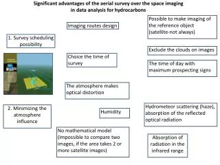
Significant advantages of the aerial survey over the space imaging in data analysis for hydrocarbons. Possible to make imaging of the reference object (satellite-not always). Imaging routes design. 1. Survey scheduling possibility. Exclude the clouds on images. Choice the time of survey.

1. Survey scheduling possibility
E N D
Presentation Transcript
Significant advantages of the aerial survey over the space imaging in data analysis for hydrocarbons Possible to make imaging of the reference object (satellite-not always) Imaging routes design 1. Survey scheduling possibility Exclude the clouds on images Choice the time of survey The time of day with maximum prospecting signs The atmosphere makes optical distortion Hydrometeor scattering (haze), absorption of the reflected optical radiation 2. Minimizing the atmosphere influence Humidity No mathematical model (impossible to compare two images, if the area takes 2 or more satellite images) Absorption of radiation in the infrared range
Satellite image resolution Standard 30x30m or 60x60m 3. Higher spatial resolution Aerial image – 5х5m Today on satellites there is no specialized equipment to highlight anomalies, caused by hydrocarbons. Widely available images provide limited data for analysis, when compared to aerial imaging made by specialized equipment, i.e. hydrocarbon detection probability is lower. 4. Shooting with specialized equipment Aerial survey data processing, unlike satellite images, is distinguished by self-training algorithm, based on the reference object’s analysis. 5. Adaptive data processing