Download
1 / 2
20 likes | 127 Views
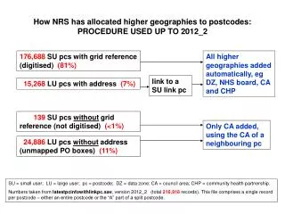
How NRS has allocated higher geographies to postcodes: PROCEDURE USED UP TO 2012_2. 176,688 SU pcs with grid reference (digitised) (81%). All higher geographies added automatically, eg DZ, NHS board, CA and CHP. link to a SU link pc. 15,268 LU pcs with address (7%).

E N D
How NRS has allocated higher geographies to postcodes:PROCEDURE USED UP TO 2012_2 176,688 SU pcs with grid reference (digitised) (81%) All higher geographies added automatically, eg DZ, NHS board, CA and CHP link to a SU link pc 15,268 LU pcs with address (7%) 139 SU pcswithout grid reference (not digitised) (<1%) Only CA added, using the CA of a neighbouringpc 24,886 LU pcswithout address (unmapped PO boxes) (11%) SU = small user; LU = large user; pc = postcode; DZ = data zone; CA = council area; CHP = community health partnership. Numbers taken from latestpcinfowithlinkpc.sav, version 2012_2 (total 216,918records). This file comprises a single record per postcode – either an entire postcode or the “A” part of a split postcode.
How NRS will allocate higher geographies to postcodes:PROCEDURE TO BE USED FROM 2013_1 176,306SU pcs with grid reference (digitised) (81%) All higher geographies added automatically, eg DZ, NHS board, CA and CHP, etc 15,764LU pcs with address (7%) link to a SU link pc 191SU pcswithout grid reference (not digitised) (<1%) Add NHS board, CA, CHP and CHP subarea only, based on pc of the local Royal Mail delivery office* 25,452 LU pcswithout address (unmapped PO boxes) (12%) SU = small user; LU = large user; pc = postcode; DZ = data zone; CA = council area; CHP = community health partnership. * Each RM delivery office is assigned to a distinct set of postcode sectors in Scotland. Numbers taken from test version of latestpcinfowithlinkpc.sav, version 2013_1 (total 217,713records). This file comprises a single record per postcode – either an entire postcode or the “A” part of a split postcode.