Download
1 / 34
340 likes | 357 Views
Explore the unique weather event of bay effect snow in the Chesapeake Bay. Discover the criteria, historical events, and potential impacts of this narrow band of snow. Learn how high-resolution models can enhance forecasting capabilities.

E N D
Bay Effect Snow from the Chesapeake Bay David F. Hamrick WPC Meteorologist College Park, Maryland
Presentation Overview • Introduction to lake effect, ocean effect, and bay effect snow • Requirements necessary for bay effect snow • November 30, 1999 event • December 25, 1999 event • January 15, 2006 event • January 24, 2013 event • October 18, 2015 mini bay-effect showers • Acknowledgments
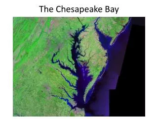
Very similar to lake effect snow events Narrow band of snow oriented north to south that affects southeast Virginia Does not happen as often as lake effect Similar processes occur downwind of Delaware Bay, Long Island Sound, and the Great Salt Lake in Utah What is Bay Effect Snow?
Bay Effect Criteria • Occurs during strong cold air advection events when cold air moves over a relatively warm body of water • Must have at least a 13 degree C difference between the water surface temperature and the 850 mb temperature • Must have little directional wind shear and minimal speed shear between the surface and about 900 mb • Must have a long and sustained wind fetch over the Chesapeake Bay with an average wind direction between 340 and 10 degrees • Progressive synoptic scale patterns tend to limit or inhibit these types of events • Land breeze convergence over the bay helps • Usually occurs from late November to January
29 November 1999 Event • The surface water temperature of the Bay was 14C (57F) and a 850 mb temperature of -10C, and this produced a temperature difference of 24C. • The wind at the Norfolk International Airport was 350 degrees at 15 kts. • This resulted in a wind fetch down entire length of the Bay and created a favorable environment for bay effect snow.
Wallops Island Sounding Data from the 30 November 1999 event
Wallops Island Sounding Data from the 25 December 1999 event
Satellite and Radar Composite during the 24 January 2013 event
Visible Satellite Imagery at 17Z 24 January 2013 with METARS
Surface Analysis and Satellite Imagery 24 January, 2013 15Z Analysis 18Z Analysis
WPC Winter Weather Forecast prior to the 24 January 2013 event
Bay effect showers 18 October 2015 Early season example that involves showers instead of snow Strong cold air advection down the length of the bay HRRR model captured these showers several hours in advance, even though they were very light
Radar Imagery at 1417 Z andHRRR Model Guidance Radar valid at 14:17 Z HRRR model valid at 14Z
HRRR Depiction of 850mb temperature and winds at 14 Z -6 -3 0
In Conclusion • Noteworthy events happen on average about every 5 years or so • It is necessary to have a steep lapse rate in the boundary layer with a high to the west and a low to the east • Can be high impact events if the band persists long enough • Bay enhancement is also possible • High resolution model data, such as the HRRR, can give indications to this within 24 hours of the event • WPC meteorologists are paying attention to these types of events
Acknowledgments • Brian Hurley – WPC lead forecaster • Mike Rusnak – WFO Wakefield • Mark Klein – WPC SOO