Download
1 / 58
640 likes | 1.29k Views
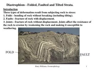
DIASTROPHISM –WARPING,FOLDING, AND FAULTING. FORCES OF PRESSURE THAT SHAPE THE EARTH’S SURFACE. WARPING. Large portions of the Earth’s crust are subjected to uplift or depression. Uplift possibly due to tectonic as well as erosion processes.

E N D
DIASTROPHISM –WARPING,FOLDING, AND FAULTING FORCES OF PRESSURE THAT SHAPE THE EARTH’S SURFACE
WARPING • Large portions of the Earth’s crust are subjected to uplift or depression. • Uplift possibly due to tectonic as well as erosion processes. • Depression usually due to glacial weight added to crust • Isostasy: rebound of the Earth’s crust as glacial weight is removed through melting and global warming
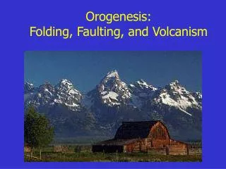
COLORADO PLATEAU: WARPING • Compression forces over last 20 million years uplifted Colorado Plateau
FORCES THAT SHAPE THE EARTH’S SURFACE • There are three main types of forces of pressure that work to shape (and re-shape) the Earth’s surface: • Compression forces (‘squeezing’) • Extension (or tension) forces (‘stretching’) • Shearing forces (‘ripping’)
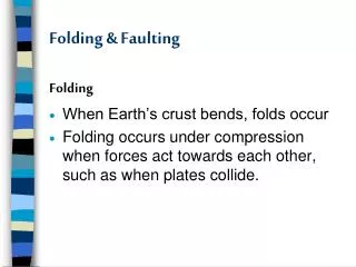
COMPRESSION FORCES: FOLDS • Folding • A fold is formed by the bending or buckling of rock layers, as a result of great force and pressure over extremely long periods of geologic time • There are two primary types of folding: • Synclines and Anticlines • Syncline: Rock layers bend downward in the folding process to form a trough-like physical feature called a syncline. This physical feature often shows itself in the form of valleys and lakes. • Anticline: Rock layers buckle upward during folding to form an arch-like structure called an anticline. This physical features often shows itself in the form of mountains or ridges.
Structure of Folds force force
FOLDS RESPOND TO TECTONICS • No compression forces and no folds • Compression forces create somewhat symmetrical upfolds (anticlines) and downfolds (synclines) • Continued compression pushes symmetrical upfold over into an ‘overturned fold’ • Compression forces cause a fault to form and pushes one limb of the ‘overturned fold’ onto the other limb • A Recumbent fold along a fault has developed
FOLDED MOUNTAINS – COMPRESSION FORCES • Folded Mountains form as the edges of two adjacent rock layers are pushed together • The layers buckle like a wrinkled rug • Mountains form from multiple parallel synclines and anticlines • Under great pressure and steady force, rocks can actually bend rather than breaking. • The Appalachian Mountains in the North America, the Himalayan Mountains in India, the Atlas Mountains in Northwest Africa, and Swiss Alps in Europe are examples of folded mountains.
Applachians Swiss Alps Himalayas Atlas Mountains
FOLDED MOUNTAINS ERODE OVER TIME Initial uplift Erosion features
FAULTING – COMPRESSION, EXTENSION AND SHEARING FORCES • When enormous stresses build and push large intact rock masses beyond their yield limit, faulting of the surface is likely to occur. • A fault is a fracture in the rock layers along which movement occurs Movement is the displacement of once connected blocks of rock along a fault plane. Displacement can occur in any direction with the broken blocks moving along the fault in opposite directions from each other.
Measuring Displacement along a Fault • Some faults have vertical displacement, while others have horizontal displacement • The measure of displacement is referred to as either “dip-slip” or “strike-slip”. • Strike: The compass direction of a line of strata • Dip: The angle in degrees between a horizontal surface and an inclined surface – measured as perpendicular to strike
UNDERSTANDING FAULT TERMINOLOGY • Faults are identified by their patterns of displacement: • Vertical (dip slip) • The movement is along the line of the dip • Horizontal (strike slip) • The movement is along the line of the strike
TOPOGRAPHIC FEATURES OF DIP SLIP FAULTS • Fault scarp: steep cliff that represents edge of vertically displaced rock • Can be 100s of meters in height • Can extend 100s of kilometers in straight lines • Sharp rise in terrain and steep slopes
Fault scarp Fault scarp
NORMAL FAULTS: DIP SLIP FAULTS • Normal faults are the result of tensional (or extensional) forces acting to pull apart the surface. • The hanging wall drops relative to the footwall. • Normal faults can occur across vast areas due to lithospheric stretching. • Basin and Range in Western USA
NORMAL FAULT: DIP SLIP Tension forces Footwall Tension forces Hanging wall
HORSTS AND GRABENS Tension forces Tension forces Mountains and Basins created by a series of parallel Normal Faults – The Basin and Range Province in Western North America is a topographic example of normal faulting: Grabens: downdropped basins Horsts: Uplifted mountains and ranges
Basin and Range Western USA exhibits ‘horst and graben’ structures due to extensional tectonics. The Western edge of the Basin and Range includes the Sierra Nevada in California. The Eastern edge of the Basin and Range includes the Wasatch Range in Utah
Faults across Basin Range Province TENSION FORCES ARE PULLING THIS AREA APART
REVERSE FAULT – DIP SLIP • Reverse faults are the result of compression forces • The footwall drops relative to the hanging wall
Reverse Fault – Dip Slip Hanging wall Footwall
REVERSE THRUST FAULT • Reverse thrust faults are the result of very low angle faults, pushing the hanging wall up and over the foot wall Hanging wall Footwall Compression forces
BLIND REVERSE THRUST FAULT • A blind reverse thrust fault does not extend to the surface – we only know of their existence because of earthquakes and surface deformation • Hanging wall lifts up and over footwall Hanging wall footwall
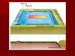
TRANSFORM FAULTS: SHEARING FORCES • Transform faults can be found at plate boundaries as one plate slides horizontally past another. • Strike-slip faults • Most transform faults are found on the ocean floor as part of the active offset along divergent plate boundaries.
TRANSFORM FAULTS: PLATE BOUNDARIES • At plate boundaries, when two tectonic plates grind past each other, there is usually no volcanism or mountain building occurring. • One of the largest transform faults in the world is the San Andreas Fault • Separating the North American Plate from the Pacific Plate in southern California.
FORMATION OF SAN ANDREAS FAULT • The northwest-southeast trending fault zone extends from the East Pacific rise in the Gulf of California (between Baja California and the Mexican mainland) to the Mendocino fracture zone offshore of northern California - approximately 800 miles
San Andreas Fault Zone • The San Andreas fault zone includes the main fault trace and many other major and minor fault strands. • The relative rate of motion between the North American plate and the Pacific plate is approximately 3.5 to 4.6 cm per year, most of which (2.0 to 3.5 cm per year) is accounted for by horizontal displacement along the San Andreas fault zone.
Evolution of San Andreas Fault • Before 30 million years ago, the western edge of the North American plate met the eastern Farallon Plate in a convergent plate boundary – complete with subduction. • The western edge of the Farallon Plate was diverging from the Pacific Plate • “East Pacific Rise” spreading center • The rate of convergence was greater than the rate of divergence and the spreading center moved towards the subduction zone.
Evolution of San Andreas Fault • Approximately 30 million years ago, the spreading center (East Pacific Rise) came into contact with the active subduction zone. • The Farallon plate was split into two pieces which are still being subducted beneath the North American plate • Juan de Fuca (northern plate) • Cocos (southern plate
Evolution of San Andreas Fault • The relative motion between the Pacific plate and the North American plate was altered to become a transform boundary. • Subduction along the transform boundary stopped. • New motion of this portion of Pacific Plate is to the northwest, parallel to the North American plate