Download
1 / 37
380 likes | 573 Views
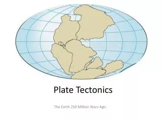
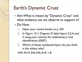
Earth’s Dynamic Crust. Aim: What is meant by “Dynamic Crust” and what evidence can we observe to support it? Do Now Open your review books to p. 245 In Figure 12-1 Diagram D label layers 2,3,4, and 5 using your scheme for sedimentary rock identification (ESRT)

E N D
Earth’s Dynamic Crust • Aim: What is meant by “Dynamic Crust” and what evidence can we observe to support it? • Do Now • Open your review books to p. 245 • In Figure 12-1 Diagram D label layers 2,3,4, and 5 using your scheme for sedimentary rock identification (ESRT) • Which of these numbered layers do you think is the oldest, why? HW: R+H 244-245, A+E 1-8
Uniformitarianism – The processes that shaped the earth we see today are still occurring and will continue to occur • Superposition – the oldest rock layers will be the deepest in the Earth (upset only by overturning and thrust faults) • Original Horizontality - sedimentary rocks and extrusive igneous rocks form in horizontal layers called strata
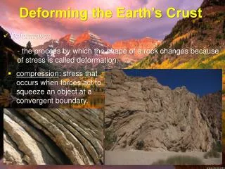
Three Forces Which Cause Crustal Disturbances • Compression – two strata moving towards one another, causes reverse faults • Tension – two strata moving away from one another, causes normal faults • Shearing- two strata moving laterally with respect to one another, causes lateral faults
Rock Layers which are no longer show original horizontalitiy are referred to as disturbed • There are three kinds of disturbed strata • Folded – bent or curved layers Syncline Anticline Occurs Because Rock Types Are Ductile – Bend Easily
3. Faulted Strata – a break has occurred in the horizontal layer This occurs because the rocks are brittle or easily broken
All three of these types of disturbed strata are evidence for crustal movement • There is one more piece of evidence… • EurypterusRemipes(and other fossils) • Marine fossil found on top of mountains in NYS • Shows evidence of crustal uplift
So… • What do you think we mean when we say “Dynamic Crust” • What have we learned about today that can support this?
Plate Tectonics 3/22/11 • Aim: What are the three types of plate boundaries and how have they formed the world we see today? • Do Now: 1. Using the diagram below please label the following; disturbed or undisturbed, oldest rock layer, foot wall, hanging wall, the stress (tension, compression, or shearing), type of fault, property of the rocks (brittle or ductile) 2. What other evidence of crustal movement did we see yesterday? HW: Finish Crustal Activity Lab
Continental Drift • http://www.youtube.com/watch?v=hSdlQ8x7cuk • Continental Drift – the movement of the Earth’s continents relative to one another • Plate Tectonics – Earth’s lithosphere is broken up into sections which move and produce the major changes in the Earth’s surface
Diverging Boundaries • Seafloor spreading creates new crust
Converging Boundaries • Subduction or crustal uplift – Island Arcs or mountain ranges
Transform Boundaries • Lateral tension builds up in the crust and is released periodically causing earthquakes
3/23/10 Aim: Features that we can see at each plate boundary and evidence for continental drift • Do Now: • Name each of the three plate boundaries, the kind of stress which forms them, and the geological features seen at each one • Please take out your Review Book and turn to page 262 HW: Finish the Crustal Activity Lab and Plate Tectonics Worksheet
Island Arcs vs. Island Chains • Island Arcs • Occur along Convergent plate boundaries • Formed by rising magma from melted subducting plate. • Ex. The Aleutian Islands • Island Chains • Occur over Hot Spots in the Earth’s mantle. • Formation of the Hawaiian Islands
Four Pieces of Evidence That Support Continental Drift and Plate Tectonics 1. Puzzle Like Fit of the Continents 2. Matching Fossils on Different Continents 4. Glacial Deposits 3. Matching Rock Formations
3/24/11 Aim: Look at rock patterns and how they relate to plate tectonics • Do Now: 1.Quiz on Plate Tectonics: Get into Test Formation HW – R&H 259–267, A&E 42-68
Magnetic Reversal • In a diverging oceanic-oceanic plate boundary cooling rocks orient themselves to magnetic north. • Over time magnetic north has switched from the geographic north pole to the geographic south pole and back again. • Geologists can match these orientations on either side of the plate boundary to show evidence of Seafloor Spreading
3/28/11 Aim: What is an Earthquake? • Do Now: • 1. Graph the relationship between rock age and distance from a mid-ocean ridge. • 2. If the Pacific Plate is moving generally northwest than which Hawaiian Island is the youngest • 3. What is the relationship between earthquakes and tectonic plates? • 4. Take out a clean sheet of paper HW: View the two animations on Earthquake Waves posted on “Mr. Jantzen’s Earth Science Videos and Animations” (Test Friday)
P-Waves • Also called primary waves or compressional waves • Faster so first to arrive • Travel through all materials • Comes from the focus S-Waves • Also called secondary waves or shear waves because they cause most of the shaking • Slower so always arrive after P-Waves • Travel through SOLIDS ONLY • Comes from the focus Surface Waves • Slowest kind of wave which travels along the surface of the earth starting at the epicenter • Travels like ripples in a pond and can cause significant damage
Practice • Figure out the difference between the P and S wave arrival times on the board for each seismogram. • If the difference in P and S wave arrival times increases with distance from the epicenter, then which seismogram came from the seismograph station closest to the earthquake?
Aim: How do we use P and S Waves to locate an earthquake? Date: 3/29/11 • Do Now: • From your homework last night explain how the P and S waves differed in the way they shook the houses • Look for a chart in your reference table that resembles the distance and travel time of seismic waves plotted in Earthquake waves video 2 • Take out a clean sheet of paper HW: R&H 246-253 A&E 9-28, Make sure to bring laptops to class tomorrow. (Test Friday)
Practice Problems • How long does it take for: • an S wave to travel 7,000 kilometers (km) • a P wave to travel 2,600 km • If the P wave arrives 5 minutes and 20 seconds after the earthquake actually occurs, how far away from the epicenter are you? When will the S wave arrive? • What is the difference in arrival time between the P and S waves if you are 4,400 km away from the epicenter. • a. What is the distance to the epicenter if the P and S wave arrive 3 minutes and 20 seconds apart. b. How long did it take the P wave to get there? c. If the P wave arrived at 2: 45 pm when did the earthquake occur
Locating Epicenters • One seismic station can give us the distance • Two seismic stations can give us distance and direction • Three seismic stations can pinpoint an exact location for an epicenter
Date: 3/30/11 Aim: What causes a tsunami? Do Now: • What is a tsunami? • Take out your laptops • Go to the class website • Look for the new page titled “Tsunami Detectives” HW: Fill in your “Tsunami Detective” Worksheet for the recent tsunami in Japan Study for Friday’s Test: Topic 12
Learning Objectives • What causes a tsunami? • How are tsunamis related to the earthquakes we studied yesterday and how are they related to the concept of a dynamic crust?
Aim: What does the Earth’s interior look like below the crust? Do Now • How can earthquake magnitude be measured? • What are some common types of volcanoes • What are some things we can do to prepare for a natural disaster? (Earthquakes, volcanoes, tsunamis) • If we cannot physically drill to the center of the earth, how can we know what it looks like? HW: R&H 255-258 A&E 29-41 Test Tomorrow STUDY
Richter Scale • Rated 1 to 10 • Measures EQ magnitude so each EQ has only one value. • Largest EQ ever recorded was an 9.5 on the Richter Scale (Chile 1960) Mercalli Scale • Rated by intensity 1 to 12 • Based on what you would feel in one area so one EQ can have many intensities • 1 detected only by seismographs and 12 is total destruction
Volcanoes Composite Cinder Cone
Emergency Planning • Earthquakes cannot be predicted • If you ever find yourself in an earthquake “drop, cover, and hold” under a strong object, you can also practice EQ drills • Proper building codes are required in areas prone to EQ’s such as type of rock underneath the building and materials used to construct the building • Always have a disaster plan • Volcanoes can be predicted by measuring the small earthquakes leading up to an eruption. • Always have a disaster plan • Tsunami warnings may offer a few hours notice. • Get to higher ground and find a secure structure • Always have a disaster plan
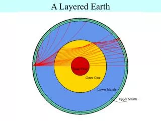
A Model of the Earth’s Interior • Properties of the earth’s interior were inferred by studying seismic waves • A wave’s speed will increase if the pressure or the density of the material it travels through are increasing • As the properties of a material change the wave is bent or refracted. Reference Tables Page 10
The Moho is a discontinuity between the crust and the mantle at which waves refract. • The asthenosphere is the solid part of the mantle with the ability to flow (plastic), this is where convection cells originate.