WIND
WIND. Including Lab: Make a ping pong ball anemometer. Wind. Wind occurs when the flow of air over the Earth's surface is unevenly heated. Warm air expands, becoming lighter. When this happens, the air rises.

WIND
E N D
Presentation Transcript
WIND Including Lab: Make a ping pong ball anemometer
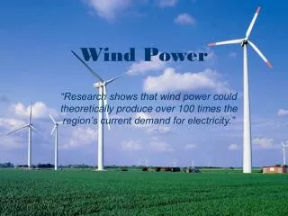
Wind • Wind occurs when the flow of air over the Earth's surface is unevenly heated. • Warm air expands, becoming lighter. When this happens, the air rises. • As the warm air rises, cooler air rushes in to fill the space left by the rising warm air. • This movement is called convection. • Wind speed can be measured with an anemometer. • At higher elevations, the air gets thinner and there is less air pressure. • This reduction in air pressure reduces frictional drag and wind speed increases. • The rotation of the Earth also affects wind. • There are six major wind belts around the Earth (easterlies, westerlies, and trade winds in both the northern and southern hemispheres) that form by convection.
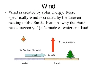
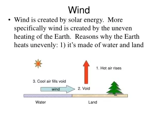
How wind forms Wind moves from an area of high pressure to an area of low pressure • Sunlight strongly heats an area of the ground. The ground heats the air. The warm air rises, and an area of low pressure forms. • Sunlight heats an area of ground less strongly. The cooler, dense air sinks slowly and an area of low pressure forms. • Air moves as wind across the surface, it moves from higher to lower pressure. Animation: cold and warm fronts Another animation
Land & Sea Breezes • Unequal heating of air over land and water results in breezes near shorelines. • While the land is warm during the day, air above it rises, and a cool breeze blows in from the sea. • As the land cools off at night, air pressure over it increases, and a cool land breeze blows out to the sea. • Examine the changing temperature of the land throughout the 24 hours represented in the animation. • Animation
Global Wind Belts • The distance wind travels varies. • Global winds travel thousands of kilometers in steady patterns. • Formed by two main factors: • unequal heating of the earth by sunlight • the earth's spin. • The unequal heating makes the tropical regions warmer than the polar regions. As a result, there is generally higher pressure at the poles and lower at the equator. Wind flows from high to low pressure. • So the atmosphere tries to send the cold air toward the equator at the surface and send warm air northward toward the pole at higher levels. • The spin of the earth prevents this from being a direct route, and the flow in the atmosphere breaks into three zones between the equator and each pole.
Global Wind Belts • A series of wind belts circles Earth. Between the wind belts are calm areas where air is rising or falling.
Bands of calm air separate global wind belts • The earth’s rotation and the uneven heating of its surface cause a pattern of wind belts separated by calm regions. • Calm Regions • Air usually stays calm; winds are light • Doldrums • Horse Latitudes • Wind Belts • Curve to the east or west because of Coriolis Effect. • Coriolis Effect: if the earth did not rotate, the wind would flow directly from the poles to the equator. The earth’s rotation changes the direction of wind and they curve to the east or west. • Name after the direction from which they blow • Trade winds • Westerlies • Easterlies
Coriolis Effect • As Earth rotates, the Coriolis effect turns winds in the Northern Hemisphere toward the right. Animation Another animation
Wind Belts • 6 total: 3 in the Northern Hemisphere (NH) & 3 in the Southern (SH). • The Trade winds: Blow from the east moving from the horse latitudes toward the equator. The strong, steady winds die out as they come near the equator. • The Prevailing Westerlies: blow from the west, moving from the horse latitudes toward the equator. They bring storms across much of the US. Most of North America fits into this belt and that is why our weather usually comes from west. • The Polar Easterlies: which blow from the east, moving from the polar regions toward the middle latitudes. Stormy weather often occurs when the cold air of the easterlies meets the warmer air of the westerlies.
Calm Regions • Doldrums: Low-pressure zone near the equator. • Warm air rises to the top of the troposphere • Since much of the air movement is vertical, winds are light. • The air and then spreads out toward the poles. • The rising, moist air produces clouds and heavy rain. • During the hottest months, heavy evaporation from warm ocean water in the region fuels tropical storms. • Sailors noticed the stillness of the rising (and not blowing) air near the equator and gave the region the depressing name "doldrums." • Horse Latitudes: High-pressure zones located about 30 ° north and30 ° of the equator. • Warm air traveling away from the equator cools and sinks in these regions. • Again, since much of the air movement is vertical, winds are light. • The weather tends to be clear and dry. und 30 degrees from the equator, cool air sinks. • Tradition states that sailors gave the region of the subtropical high the name "horse latitudes" because ships relying on wind power stalled; fearful of running out of food and water, sailors threw their horses and cattle overboard to save on provisions.
A circulation cell is a giant loop of moving air that includes a wind belt and the calm regions that border it. The trade winds blow from the horse latitudes toward the equator Air rises in the doldrums The westerlies blow from the horse latitudes toward the poles Air sinks in the horse-latitudes; a high pressure zone The easterlies blow away from the polar regions
Ping Pong Ball Anemometer • Materials • Masking Tape • Pencil • Protractor • Sewing Thread • Ping Pong Ball
Procedure • Tape the pencil to the straight edge of the protractor. • Tape one end of the thread to the ping-pong ball. • Tape the other end of the thread to the center of the straight edge of the protractor. The thread should hang so that it crosses the 90-degree mark on the protractor. • Use the pencil as a handle and hold the instrument so that the ball is about 12 inches from your helper’s face. • Ask your helper to gently blow a stream of air toward the ball on the instrument. Observe where the string crossed the protractor. Record angle on the chart below and determine the wind speed using the conversion table on the back of this sheet. • Ask your helper to blow harder as you observe the position of the string on the protractor, again. Record results below. Take turns and complete five separate trials at varying wind speeds.