Download
1 / 17
170 likes | 323 Views
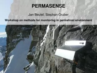
PERMASENSE Geo-science and engineering functioning together. Stephan Gruber , Jan Beutel, Andreas Hasler, Igor Talzi, Christian Plessl, Mustafa Yuecel, Roman Lim, Christian Tschudin, Lothar Thiele, Karl Aberer. Climate rapidly affects the high-mountain hazard regime.

E N D
PERMASENSEGeo-science and engineering functioning together Stephan Gruber, Jan Beutel, Andreas Hasler, Igor Talzi, Christian Plessl, Mustafa Yuecel, Roman Lim, Christian Tschudin, Lothar Thiele, Karl Aberer
Climate rapidly affects the high-mountain hazard regime. Anticipation and minimization of adverse effects requires: Understanding mechanisms of thaw and cryogenic rock movement Provision of transient spatial data fields of relevant variables High lateral variability as well as difficult access and environmental conditions constrain measurements: Weight and size of equipment Time consumption (installation, maintenance, data gathering) Completeness of data recovery Robustness (temperature, lightning, mechanical wear) Synchronization Sacrificial sensors Geo-science motivation to use WSNs
With PERMASENSE, we aim to: provide long-term high-quality sensing in harsh environments facilitate near-complete data recovery and near real-time delivery obtain better quality data, more effectively obtain measurements that have previously been impossible provide relevant information for research or decision making Reliability, delivery of information in near real-time, and integration of diverse sensors are ingredients for the next generation of early-warning systems. Aims and vision
Initiated by UniZH and UniBasel in 2006 (Tschudin, Gruber) Co-funded by FOEN in order to: (a) investigatepermafrost thaw and hazards, and to (b) pioneer WSNs for environmental monitoring and early-warning. Developed 1st generation system from scratch Prototype deployment on Jungfraujoch site in 09/2006 ETH Zurich joins in 2007 (Beutel, Thiele) Development of custom DAQ hardware System testing on DSN testbed Deployment on Matterhorn site in 09/2007 (different sensors and logging) Joint effort to develop 2nd generation system Deployment of networking system in 07/2008 EPFL joins in 2008 (Aberer) Data backend integration Project evolution
Focus: Heat transfer Status: Ready for upgrade Data: Exploratory data gathering in winter 06/07 Deployment 2006:Jungfraujoch, 3500m
Focus: Cryogenic rock movement Status: Productive since July 08 (logging since Oct. 08) Deployment 2007:Matterhorn, 3400m
Shockfish TinyNode Protective shoe, simple installation Waterproof housing and connectors Sensor Interface Board 3-year lifetime with single battery(~300 A average power budget) Sensor nodes
Development started in 2007 Diverse interfaces, low power New: 1 GB memory (redundancy and validation) Provides very stable measurements Sensor interface board (SIB)
Sensor rods (profiles of temperature and electric conductivity) Thermistor chains Crack meters Water pressure Ice stress Self potential Sensors
Powerful embedded Linux 4 GB storage, all data duplicated Solar power Backup modem Base station
TinyOS-based, fully customized Integration of Dozer (MICS, IPSN_07) DAQ routine, profited from SNPK(Sensor Network Platform Kit, MICS) Integration of GSN data backend (Global Sensor Network, MICS, VLDB_06) Ongoing algorithmic research: in-memory downsampling (storage in limited flash memory), intermittent connectivity aspects, code optimization Software
Networking performance(Deployment-Support Network, MICS, EWSN_07) Power profiling Temperature and humidity cycling Sensor calibration Rooftop system break-in Testing facilities
Geo-science starts now Excellent measurement stability Emerging challenge: turning data into relevant information(aggregation, merging distributed sensing and modeling) Data and geo-science
Mountains are demonstrator, real relevance much greater Large potential for hazard surveillance and warning systems Solid basis for continued two axis (geo/eng.) funding and integration Outlook
Live system since July 2008 Experienced and motivated multi-disciplinary team Integration and refinement of existing technologyMICS: SNPK, DSN testbed, Dozer & GSN Quick adaptation of resources to challengesflexible MICS financing Sound strategic basis and vision for continuation Summary of main achievements
Please look at our live demo outside Thank you