Download
1 / 12
120 likes | 212 Views
Learn about the recent evolution of Equatorial Pacific SST departures, ENSO-neutral status, and predictions for the upcoming seasons.

E N D
ENSO Cycle: Recent Evolution, Current Status and Predictions Update prepared by Climate Prediction Center / NCEP 19 November 2012
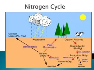
Summary • ENSO Alert System Status: Not Active • ENSO-neutral conditions continue.* • Equatorial sea surface temperatures (SST) remain above average across much of the Pacific Ocean. • The atmospheric circulation over the tropical Pacific is near average. • ENSO-neutral is favored through the Northern Hemisphere winter 2012-13. * Note: These statements are updated once a month in association with the ENSO Diagnostics Discussion: http://www.cpc.ncep.noaa.gov/products/analysis_monitoring/enso_advisory
Recent Evolution of Equatorial Pacific SST Departures (oC) Time From September 2011- January 2012, below-average SSTs were evident across much of the equatorial Pacific Ocean. Recently, above-average SSTs have persisted across much of the tropical Pacific, with relatively weaker SST anomalies in the eastern Pacific. Longitude
Niño Region SST Departures (oC) Recent Evolution The latest weekly SST departures are: Niño 4 0.7ºC Niño 3.4 0.5ºC Niño 3 0.2ºC Niño 1+2 -0.5ºC
SST Departures (oC) in the Tropical Pacific During the Last 4 Weeks • During the last 4-weeks, equatorial SST anomalies were more than +0.5ºC between 145ºE and 140ºW. SSTs were 0.5ºC below average in a small region of the eastern Pacific.
Weekly Central & Eastern Pacific Upper-Ocean (0-300 m) Average Temperature Anomalies Since April 2012, the anomalies have been positive with increases during April and June. Positive subsurface anomalies weakened during September, strengthened slightly during October, and have weakened so far in November.
Sub-Surface Temperature Departures (oC) in the Equatorial Pacific • In October, positive subsurface temperature anomalies strengthened across the equatorial Pacific. • Recently, positive subsurface temperatures anomalies have weakened in the central Pacific. Time Most recent pentad analysis Longitude
Tropical OLR and Wind AnomaliesDuring the Last 30 Days Negative OLR anomalies (enhanced convection and precipitation, blue shading) were observed near Papua New Guinea. Positive OLR anomalies (suppressed convection and precipitation, red shading) were apparent over Indonesia and west of the Date Line. Anomalous low-level (850-hPa) easterly winds were evident across the western Pacific Ocean. Upper-level (200-hPa) winds were near average across the equatorial Pacific.
Low-level (850-hPa) Zonal (east-west) Wind Anomalies (m s-1) Westerly wind anomalies (orange/red shading). Easterly wind anomalies (blue shading). Time Recently, weak wind anomalies are evident across the equatorial Pacific Ocean. Longitude
CPC/IRI Probabilistic ENSO Outlook(updated 8 Nov 2012) ENSO-neutral is favored through mid-2013.
Pacific Niño 3.4 SST Outlook • Most models predict either persistence or a gradual weakening of current Niño-3.4 values, with ENSO-neutral continuing into the Northern Hemisphere summer 2013. • The average dynamical model forecast is warmer than the statistical model mean. Figure provided by the International Research Institute (IRI) for Climate and Society (updated 13 Nov 2012).
SST Outlook: NCEP CFS.v2 Forecast Issued 18 November 2012 The CFS.v2 ensemble mean (black dashed line) predicts below-average SSTs during N. Hemisphere winter 2012-13. CFS.v1 has been discontinued.