Maximizing Coastal Observation: The MARCOOS Project
120 likes | 223 Views
Leveraging existing assets to establish a regional Coastal Ocean Observing System supporting safety, ecology, and regional initiatives. Project components include radar networks, gliders, models, data integration, education, and economic benefits.

Maximizing Coastal Observation: The MARCOOS Project
E N D
Presentation Transcript
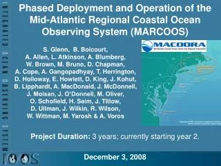
Phased Deployment and Operation of the Mid-Atlantic Regional Coastal Ocean Observing System (MARCOOS)Project Duration: 3 years; currently starting year 2.December 3, 2008 S. Glenn, B. Boicourt, A. Allen, L. Atkinson, A. Blumberg, W. Brown, M. Bruno, D. Chapman, A. Cope, A. Gangopadhyay, T. Herrington, D. Holloway, E. Howlett, D. King, J. Kohut, B. Lipphardt, A. MacDonald, J. McDonnell, J. Moisan, J. O’Donnell, M. Oliver, O. Schofield, H. Seim, J. Titlow, D. Ullman, J. Wilkin, R. Wilson, W. Wittman, M. Yarosh & A. Voros
Project Overview • Project Goals: • Leverage existing assets to establish a • Regional Coastal Ocean Observing System • to support MACOORA Regional Themes: • Maritime Safety – provide regional surface currents maps to improve Search And Rescue, Hazardous Spill Response & Rip Current forecasts. • Ecological Decision Support – provide regional 3-D temperature and circulation data & hindcasts for the recreational, commercial and fishery management communities. • Provide regional-scale inputs to MACOORA’s nested subregional efforts on Coastal Inundation and Water Quality.
Project Overview NWS WFOs Std Radar Sites Mesonet Stations LR HF Radar Sites Glider AUV Tracks USCG SLDMB Tracks NDBC Offshore Platforms CODAR Daily Average Currents • MARCOOS Major Elements -10: • Atmospheric Data Integration • HF Radar Network Operations • HF Radar Data QA/QC • Underwater Glider Operations • Satellite Data Acquisition • Statistical Modeling • Dynamical Modeling • DMAC • Education & Outreach • Economic Benefits 3
Project Overview • Desired Outcomes: • Collaborate with NOAA WFOs to link existing regional coastal weather networks to evolving NOAA WRF regional forecasting capabilities – to provide an improved ensemble of weather forecasts. • Operate the existing Mid-Atlantic HF Radar network and leverage Coast Guard drifter data linked to statistical and dynamical models – to provide an ensemble of regional nowcasts and forecasts of 2-D surface currents. • Operate the existing satellite receivers and leverage the Navy investment in a regional glider capability linked to dynamical models – to provide an ensemble of 3-D circulation, temperature and salinity nowcasts and hindcasts. • Form a MARCOOS data management team – to facilitate implementation of an end-to-end system consistent with DMAC standards. • Form an Education & Outreach planning team – to engage additional users. • Form an Economic Impact planning team – to assess the benefits of MARCOOS information. • Develop a management structure that establishes and monitors performance metrics – to ensure quality. 4
Project Overview • Include how you measure success (success metrics) • Milestone Chart – Progress enabled with monthly conference calls, semi-annual meetings & semi-annual reports. • HF Radar operational performance metrics – • Coordinated with National HF Radar Network. • 12 of 13 Long Range Radars Deployed • Average 78% data availability • October 1, 2007 to October 1, 2008 • RA outcome metrics – Membership satisfaction, growth, interest. • Additional support for Federal Backbone assets. • Tracking new projects or grants that leverage MACOORA & MARCOOS. 5
Project Status Report • Significant Accomplishments: • Existing observational capacities ($20 M/year) required prioritization - MARCOOS regional priorities were successfully set based on user input acquired by the Regional Association (MACOORA). • Over 20 existing subregional observing systems spanning 10 States & 111 Congressional Districts were successfully linked in a coordinated Regional Coastal Ocean Observing System (RCOOS). • MARCOOS Theme 1 – Coast Guard Search And Rescue - provided additional activation energy for a growing National HF Radar Network. • MARCOOS Theme 2 – Fisheries - has generated support at the Large Marine Ecosystem Level with NOAA fisheries scientists, recreational and commercial fishers. • Demonstrated that new technologies chosen for regional-scale observations and forecasting are sustainable at typically available funding levels. • Established training & education programs for workforce development. • Demonstrated importance of DMAC, E&O and Economic Impact efforts. • Provided a sustained testbed to help attract other programs – DHS COE, DoD MURI, NSF OOI & COSEE-NOW, NWQMN Pilot, NOAA Fisheries, States. 7
Keys to Success • What worked well & why? • Prioritization of regional themes • - Support of the Regional Association • - Dedicated Partnering Meetings – Water Quality, Inundation, Fisheries • - MARCOOS Economic Impact Team for targeting users • Designing the RCOOS • - Limited the scope - focused on linking and strengthening core capabilities • - Leveraged existing assets - RA built trust over several years between individuals in a wide variety of academic, industry and government efforts. • - Partnering – User Co-PI’s, E&O Team links providers with users. • Implementing the end-to-end system • - MARCOOS DMAC SWAT Team - now MACOORA-wide • - Partnership Approach, Multiple Communication Opportunities • - Generated broader support – RA & RCOOS provides a leveraging framework to attract other agencies and industry.
Potential Benefit to Others • How might your project be relevant to other regions or federal agencies? • - National HF Radar Network Evolution • - Glider operations and training • - Statistical model approaches for short term predictions • - Data assimilative ensemble modeling approaches • - Federal agency interest – NSF, ONR, DoD, DHS, EPA, MMS, USGS • If so, what would be required to transfer key elements to other regions, federal agencies, and users? • - Partnerships to define regional goals • - Scientists to validate data and models • - Experienced technicians to implement • Does this project include a component to transfer or extend project results to other regions and users? If so, please describe. • - Not as a funded activity. • - Collaborations with 10 of 11 RAs are being pursued through other means. • - Student participation in IOOS activities.
Challenges • Describe potential and/or real challenges (i.e., such as institutional barriers, technical barriers, scientific barriers, personal, etc) you are facing in accomplishing the established milestones. • Institutional: • - Spatial overlap between MACOORA & NERACOOS. • - RA is not well structured to respond to non-IOOS RFPs. • Technical: • - HF Radar Operations-Need technicians, spare parts, redundant systems. • - Glider Operations-Need sufficient Gliders, technicians, operations costs. • - Dynamical Models-Need Personnel for sustained real-time operations. • Scientific: • - Scientific basis for Ecosystem Based Management is still being established in our Large Marine Ecosystem. • Personnel: • - Primary challenge is the personnel required for sustained operations – this is a simple support level issue, not a complex willingness issue.
Challenges • Resolving challenges - How might these challenges be resolved? (Besides additional financial resources) For example, are there actions that NOAA or other federal agencies could take to assist? • Relation between NERACOOS & MACOORA will strengthen over time • - We are linked by the Large Marine Ecosystem and new observing technologies. • Science Teams are a MACOORA product for diversifying funding. • Eager to work with NOAA to enhance the Federal Backbone. • Specifically – PORTS, Buoys at the shelf break, WRF weather forecasts. • Continue to develop national capabilities where it makes sense – e.g., HF Radar network, ONR Glider Consortium. 11
Stakeholder Response • How are you engaging stakeholders in this project? • - Data Web pages have been active since 1994 • - MACOORA Annual Regional meeting • - Dedicated Subregional meetings on focus topics • - As Co-PI’s on MARCOOS and follow-on projects • How are stakeholders responding to the project to-date? • - Constant email traffic, increasing interest in MACOORA. • - MACOORA-MARCOOS are now being invited to stakeholder meetings. • - MARCOOS is transitioning into an asset for attracting additional funds. • How are you tracking stakeholder satisfaction? • - Web hits, emails, surveys. • - Talking with major users. • - Membership in MACOORA, letters of support, petitions.