Download
1 / 17
170 likes | 349 Views
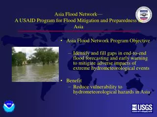
Asia Flood Network— A USAID Program for Flood Mitigation and Preparedness in Asia. Asia Flood Network Program Objective Identify and fill gaps in end-to-end flood forecasting and early warning to mitigate adverse impacts of extreme hydrometeorological events Benefit

E N D
Asia Flood Network—A USAID Program for Flood Mitigation and Preparedness in Asia • Asia Flood Network Program Objective • Identify and fill gaps in end-to-end flood forecasting and early warning to mitigate adverse impacts of extreme hydrometeorological events • Benefit • Reduce vulnerability to hydrometeorological hazards in Asia
Asia Flood Network—A Program for Flood Mitigation and Preparedness in Asia • Develop partnerships between hydrometeorological entities in Asia and US counterparts, such as: • US Agency for International Development Office of Foreign Disaster Assistance (OFDA) • US Geological Survey (USGS) • National Oceanic and Atmospheric Administration (NOAA) • Pre-program assistance to the Mekong River Commission (MRC) began in 2001 in the form of daily rainfall estimation and forecast
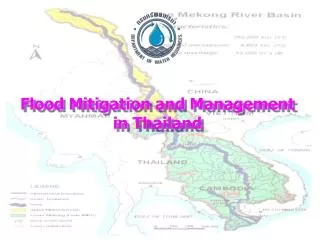
Asia Flood Network—A Program for Asian Flood Mitigation and Preparedness • Process • Asia Flood Network was launched in 2003 by OFDA, with technical support from NOAA and USGS • Initial dialogue is centered on the Mekong River basin and assisting MRC’s recently adopted Flood Management Program • Other activities include the Ganges-Brahmaputra-Meghna (GBM) Basin and other basins in Asia
Asia Flood Network—A Program for Asian Flood Mitigation and Preparedness Operational and Developmental Technologies • USGS and NOAA automated hydrometeorological data-collection • GOES (and other meteorological) satellites for real-time data relay • NOAA National Weather Service River Forecast System (NWSRFS) • USGS GeoSpational Forecast Model • Tropical Rainfall Measuring Mission • Distribution of data and warnings
National Hydrologic Information System USGS Monitoring in the United States Data Centers Courier Internet Graphical User Interfaces Reports, bulletins, maps,…
National Hydrologic Information System—Demand Driven USGS Hydrologic Information System is demand driven through cooperative funding agreements with >1,600 State, county and local agencies and other Federal Agencies • Demand driven by data and analysis needs for: • Forecasting and Warning • Water Planning and Management • Navigation • Recreation • Environmental Protection
Flood Warning System, a Special-Case Hydrologic Information System Forecast and Warning Dissemination Planning and Coordination Data Communication • A System Where: • Time is critical • River forecasts becomes flood forecasts • Products are forecasts and warnings • Users have planned and are prepared Action
Flash-Flood Warning Systems Community based protection via real-time Alert Systems • Alert systems: • Community based and operated • Small geographical areas • Rapid response • More monitoring and warning than forecasting • Provide warnings to the public and emergency response organizations • Information at http://www.udfcd.org/Nhwc/nhwc.htm
NWS Large River Forecasting Multi-day river forecasts are prepared every six hours for 4,000 forecast points on large rivers from 13 River Forecast Centers, using a common NWS River Forecast System (NWSRFS) NWSRFS contains >40 hydrologic and hydraulic models, includes Xinanjiang Soil Moisture Accounting Model
NWS Large River Forecasting Products include short-term and ensemble forecasts The forecasting system continues to be modernized and supported under the Advanced Hydrologic Prediction Service Program
USGS GeoSFM GeoSFM is being validated in Distributed Model Intercomparison Project (DMIP) basins with good results, using a standard NOAA-provided data set from a data-rich area in the United States
Integration of USGS-NOAA Tools USGS and NOAA are integrating GeoSFM into the NWSRFS to provide: • OFDA and potential Asian partners with a new tool for river and flood forecasting, that can be implemented promptly • NOAA with a spatially based interface to NWSRFS • USGS with a system in which to operate GeoSFM
Tropical Rainfall Measuring Mission (TRMM) (http://trmm.gsfc.nasa.gov/) A developmental US-Japanese mission that produces tropical rainfall estimates from satellite-based : • Precipitation radar • TRMM Microwave Imager • Visible Infrared Scanner • A lightening Imaging Sensor • The Clouds and Earths Radiant Energy System • Data at http://trmm.gsfc.nasa.gov/data/quicklook/last_2_cal.html
Provision of Flood Early Warning to Flood-Vulnerable Communities in the Lower Mekong River Basin • A joint project of the Office of U.S. Foreign Disaster Assistance (OFDA) and the Mekong River Commission (MRC) to provide in Phase 1: • MRC flood information that is responsive to the needs of—and promptly conveyed to—the most flood-vulnerable communities in Cambodia and Lao PDR; and • Tools, methods and protocols to enable flood-vulnerable populations in Cambodia and Lao PDR to effectively respond to MRC flood information.
Asia Flood Network—Summary • Flood mitigation and preparedness via the transfer flood-forecasting and warning technologies to: • Mekong River Commission Flood Management Program • Mekong River Basin Riparian Countries, through the MRC FMM Capacity Building and Technology Transfer Role • South Asian Counterparts in the Hindu Kush Himalayan Region • Short-term activities focus on proposal preparation and include: • USGS, NOAA, and MRC consultative visits to riparian countries • Riparian visits to the United States