Download
1 / 22
220 likes | 351 Views
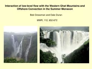
Interaction of low-level flow with the Western Ghat Mountains and Offshore Convection in the Summer Monsoon. Bob Grossman and Dale Duran. MWR, 112, 652-672.

E N D
Interaction of low-level flow with the Western Ghat Mountains and Offshore Convection in the Summer Monsoon Bob Grossman and Dale Duran MWR, 112, 652-672
During the monsoon season between June and September, the unbroken Western Ghats chain acts as a barrier to the moisture laden clouds. The heavy, eastward-moving rain-bearing clouds are forced to rise and in the process deposit most of their rain on the windward side. Rainfall in this region averages 3,000–4,000 mm (120–160 in) with localized extremes touching 9,000 mm (350 in). The eastern region of the Western Ghats which lie in the rain shadow, receive far less rainfall averaging about 1,000 mm (40 in) bringing the average rainfall figure to 2,500 mm (150 in).
Principal areas of offshore convection in Monsoon Area addressed in paper
Geography Typical summer monsoon flow
Triggering of the summer monsoon: Traditional thinking: Sensible heating over desert regions produces divergence aloft and a surface low which draws air into continent. Alternate explanation: Monsoon is first triggered by heating associated with latent heat release associated with deep convection triggered upstream of topographic barriers like the Western Ghats Purpose of paper: To show that the Western Ghats are capable of contributing to the production of deep convection well offshore by gentle lifting of potentially unstable air as it approaches the coast. Hypothesis: Lifting is due to decelleration of air as it approaches ridge of high pressure generated by blocking of flow by the Western Ghats
22 June 1979 –Surface Pressure No offshore convection west of Ghats on this day 24 June 1979 –Surface Pressure Offshore convection west of Ghats on this day Not a lot of difference in the surface pressure fields in these analyses Note pressure ridge…upstream blocking of flow?
Occurrence of “highly reflective clouds” determined from Satellite visible imagery for June 1979 Percent occurrence Assumption: These are indicative of the presence of deep convection rather than anvils of older convection Standard deviation
The boundary layer flights from which the study was derived Area of deep convection Downstream boundary layer profile Upstream boundary layer profile Surface fluxes
Conditions at time of flight based on a TIROS-N satellite Mosaic (no GOES at that time)
What they had to work with Data from Electra (on stripcharts and microfilm): 1s averages Horizontal velocity Pressure Altitude Temperature Moisture Up and down IR and Shortwave radiation Dropwindsondes Satellite data Radar images on paper
Important points: West to East increase in ABL values of e – ABL is warming and moistening (Temp 0.5K, Moisture 1 g/kg) Cumulus congestus affected e in the middle of the section SST increased 2.5K, 1.7 K in last 250 km Wind direction constant in vertical by 240 deg at upstream profile and 255 at downstream profile Wind speed continually decreases toward India Wind Speed Equiv. Pot. Temp
Characteristics of the cross section Cloud structure Lifting condensation level Pressure (lots of corrections applied make this fishy Wind speed Vertical velocity calculated based on 1-D divergence of wind
Horizontal momentum equation averaged over a volume along a trajectory from the upstream profile to the downstream profile Horizontal advection Vertical advection Friction (flux Divergence) Local time derivative PGF With a lot of hand-waving and no error analysis
Argues that calculations are OK based on the fact that increased with time
Mountain wave model – uses the Lilly and Klemp (1979) model for flow over a mountain. Problem: Requires atmosphere where the stability and wind are constant with height Actual case: Winds are westerly below 4 km, easterly above. Solution: Assume linear solution with upward propagating waves absorbed at the wind reversal level (critical level). Is this really the way it works??
Solution does also not include effects of rotation, 3-D non uniformities, surface friction, and convection
Final approach: Average soundings in upstream area of Arabian Sea and determine if soundings on convective days differ from those on non-convective days (based on satellite images)
Final approach: Average soundings in upstream area of Arabian Sea and determine if soundings on convective days differ from those on non-convective days (based on satellite images)
significantly drier cooler
Dry air from non-convective soundings in mid levels (more air off deserts)