Download
1 / 19
190 likes | 265 Views
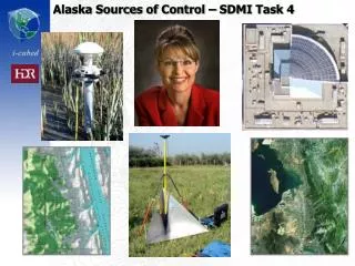
Conduct a survey of existing control sources in Alaska from public and private entities to explore their utility in geodesy, civil engineering, aviation, and more. Consider factors like map scale, accuracy, costs, and access for effective utilization.

E N D
Goal & Approach • Conduct a survey of existing control sources. • Public and private sources that could be acquired for Alaska utilization. • Separate existing image identifiable content • Also gather pragmatic feedback from existing practitioners • Produces maps and report
Just because you’ve got itdoesn’t mean it’s the right fit for the job
What is the Application • Geodesy, Costal, Civil Engineering? • Aviation? • Control imagery? • 1:24k NMAS • EO or RaDAR • Correlate with other datasets? • Change detection, veg mapping, EIS? • Control DEM? • Validate imagery or DEM? • Control collection platform?
Some Variables • Desired map scale / accuracy of output products • Interaction with other input components • Error budget • Image identifiability • Orientation related to area of mapping • Stability over time (seasons and years) • Costs of collection • Access • Costs of utilization
Imagery Ortho Error Budget • Many factors contribute to the overall accuracy of map product • DEM • Incidence angle, sensor to ground • GCP • Sensor design • Orbital Position Estimation • AGPS & IMU / Pointing Accuracy • Block size
DEM Accuracy is Significant Error Source for Imagery Location
GCP Accuracy • Keep mapping scale in mind • 1:24K means a 0.1mm thick line is 2.4m wide on the ground! • To achieve NMAS, >90% of all sample points must fall less than 40 feet (12.19m) from ground truth
GCP Accuracy • Most modern survey grade GNSS receivers capable of +/- 5mm + 0.5ppm (1 sigma) • CORS may provide sufficient coverage if SDMI requirements are 1:24,000
Alternatives to CORS • TerraPOS – uses precise GPS satellite ephemeris
GPS and GNSS • Raise elevation mask 2⁰/100km from base to ensure common satellites observed • If possible, use a GNSS receiver rather than straight GPS – better for mountains