Download
1 / 26
510 likes | 1.14k Views
Where f o = 0 (latitude of the central meridian at the origin of the x, y coordinates) M = True distance along central meridian from the equator to f ( across from the point ) M o = 0 (M at f o ) l o = longitude of central meridian (for UTM zone)

E N D
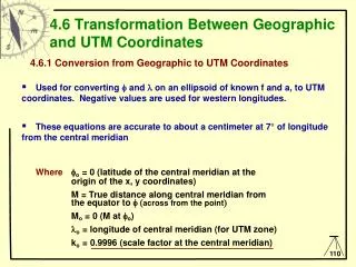
Wherefo = 0 (latitude of the central meridian at the origin of the x, y coordinates) M = True distance along central meridian from the equator to f (across from the point) Mo = 0 (M at fo) lo = longitude of central meridian (for UTM zone) ko = 0.9996 (scale factor at the central meridian) 4.6 Transformation Between Geographic and UTM Coordinates 4.6.1 Conversion from Geographic to UTM Coordinates • Used for converting f and l on an ellipsoid of known f and a, to UTM coordinates. Negative values are used for western longitudes. • These equations are accurate to about a centimeter at 7° of longitude from the central meridian
4.6 Transformation Between Geographic and UTM Coordinates Radius of curvature at a given azimuth FROM EQUATION SHEET Radius of Curvature in the plane of the meridian Radius of curvature on the plane of the prime vertical Rm Ra RN
é ù æ ö æ ö 2 4 6 2 4 6 e e e e e e ç ÷ ç ÷ - - - - f - + + + f + 1 3 5 3 3 45 sin 2 ê ú L L ç ÷ ç ÷ 4 64 256 8 32 1024 è ø è ø ê ú = M a ê ú æ ö æ ö 4 6 6 e e e ê ú ç ÷ ç ÷ + + f - + f + 15 45 sin 4 35 sin 6 L L L ç ÷ ç ÷ ê ú 256 1024 3072 è ø è ø ë û f w here is in radians 4.6 Transformation Between Geographic and UTM Coordinates 4.6.1 Conversion from Geographic to UTM Coordinates = f 2 T tan = f 2 2 C e ' cos = A
é ù ( ) 3 5 A A ( ) + - + + - + + - x 2 2 = k R A 1 T C 5 18 T T 72 C 58 e ' ê ú N o 6 120 ë û ì ü é ù ( ) ( ) 2 4 6 A A A = - + f + - + + + - + + - 2 2 2 y k M M R tan 5 T 9 C 4 C 61 58 T T 600 C 330 e ' í ý ê ú N o o 2 24 720 ë û î þ é ù ( ) ( ) 2 4 6 A A A ( ) = + + + - + + - + - + 2 2 2 k k 1 1 C 5 4 T 42 C 13 C 28 e ' 61 148 T 16 T ê ú o 2 24 720 ë û é ù ( ) 2 x ( ) = + + f 2 2 k k 1 1 e ' cos ê ú o 2 2 2 k R ë û N o 4.6 Transformation Between Geographic and UTM Coordinates 4.6.1 Conversion from Geographic to UTM Coordinates Northing and Easting UTM Scale Factor Or in terms of Latitude and Longitude
4.6 Transformation Between Geographic and UTM Coordinates 4.6.2 Conversion from UTM to Geographic Coordinates Used for converting UTM coordinates on an ellipsoid of known f and a, to f and l. Negative values are used for western longitudes. These equations are not as accurate as the geographic to UTM conversion Where f1 = footprint latitude which is the latitude at the central meridian which has the same y coordinate of the point m = the rectifying latitude
y = + M M o k o M m = æ ö 2 4 6 e e e ç ÷ - - - - a 1 3 5 L ç ÷ 4 64 256 è ø - - 2 e 1 1 = e 1 + - 2 e 1 1 æ ö æ ö 3 2 4 e e e e ( ) ( ) ç ÷ ç ÷ f = m + - + m + - + m 1 1 1 1 3 27 sin 2 21 55 sin 4 L L ç ÷ ç ÷ 1 2 32 16 32 è ø è ø æ ö æ ö 3 4 e e ( ) ( ) ç ÷ ç ÷ + + m + - m + 1 1 151 sin 6 1097 sin 8 L L L ç ÷ ç ÷ 96 512 è ø è ø m w here is in radians f C , T , R , and R are C, T, R , and R calculated at the footprint latitude ( ) N N 1 1 1 1 m 1 x = D R k N 1 o 4.6 Transformation Between Geographic and UTM Coordinates 4.6.2 Conversion from UTM to Geographic Coordinates
é ù ( ) 2 4 D D - + + - - 2 2 T C C e 5 3 10 4 9 ' ê ú ( ) æ ö f 1 1 1 tan 2 24 ê ú ç ÷ f - R 1 ç ÷ N 1 1 R ê ( ) ú 6 D è ø 1 + + + + - - 2 2 2 T C T e C 61 90 298 45 252 ' 3 ê ú 1 1 1 1 ë û 720 ( ) 3 5 D D ( ) 2 - + + + - + - + + 2 2 D T C C T C e T 1 2 5 2 28 3 8 ' 24 1 1 1 1 1 1 6 120 l + ( ) o f cos 1 4.6 Transformation Between Geographic and UTM Coordinates 4.6.2 Conversion from UTM to Geographic Coordinates f = l =
Elevation factor (Scale factor to sea level) (The UTM scale factor can also be approximated using the average radius of the earth.) The grid scale factor for UTM maps can then be computed using either the approximate or true values = (Elevation factor) G rid Factor (scale factor) X Grid distance = Ground Distance Grid factor 4.6 Transformation Between Geographic and UTM Coordinates 4.6.3 UTM Map Scale Factor The elevation factor can be approximated using the average radius of the earth (R=6,367,272m) and elevation above the geoid rather than the elevation above the ellipsoid. This is done because of the relatively small value of N in comparison to H, and because the geoid height is usually used for elevation. Approx. Elevation factor Elevation factor Approximate UTM S cale factor
4.6 Transformation Between Geographic and UTM Coordinates 4.6.3 UTM Map Scale Factor [Review] Central Meridian Ground surface H h Mean sea level N Projection surface Ellipsoid surface R ko = 1.00 ko = 1.00 ko = 0.9996
4.6 Transformation Between Geographic and UTM Coordinates 4.6.4 EXAMPLE A GIVEN: Points on map from geodetic bench marks Map: NAD27, 1:250,000 NTS map of 72H (Willow Bunch Lake) f = 49°15’N l = 104°20’W Approx. Elevation h = 2430 ft = 740.66m • FIND: • UTM coordinates for point A, where: • a = 6,378,206.4 m 1/f = 294.9786982 • f = 49°15’N = 49.25° = 0.859575 radians • l = 104°20’W = -104.3333° = -1.82096 radians (UTM zone 13) • lo = 105° W ko= 0.9996 fo = 0°
Example 4.6 Transformation Between Geographic and UTM Coordinates 4.6.4 EXAMPLE A
- 2 1 e 6 , 372 , 127 . 842 m = = R a ( ) M 3 - f 2 2 2 1 e sin a = = = R N 6 , 390 , 630 . 874 m N ( ) - f 2 2 1 e sin = f = 2 T tan 1 . 34689285 = f = 2 2 C e ' cos 0 . 00290374 ( ) = l - l f = A cos 0 . 0075952 o é ù æ ö æ ö 2 4 6 2 4 6 e e e e e e ç ÷ ç ÷ - - - - f - + + + f + 1 3 5 3 3 45 sin 2 ê ú L L ç ÷ ç ÷ 4 64 256 8 32 1024 è ø è ø ê ú = = M a 5457211 . 606 ê ú æ ö æ ö 4 6 6 e e e ê ú ç ÷ ç ÷ + + f - + f + 15 45 sin 4 35 sin 6 L L L ç ÷ ç ÷ ê ú 256 1024 3072 è ø è ø ë û = M 0 o 4.6 Transformation Between Geographic and UTM Coordinates 4.6.4 EXAMPLE A = - = 2 2 e 2 f f 0 . 00676865 2 e = = 2 e ' 0 . 00681478 - 2 1 e N used in this equation is not to be confused with geiodal height.
5 ù é ( 3 ) A A ( ) 2 = + - + + - + + - 2 x k N A 1 T C 5 18 T T 72 C 58 e ' ê ú o 6 ë 120 û E = 548,518.544 m ì ü é ù ( ) ( ) 2 4 6 A A A = - + f + - + + + - + + - 2 2 2 y k M M N tan 5 T 9 C 4 C 61 58 T T 600 C 330 e ' í ý ê ú o o 2 24 720 ë û î þ UTM Coordinates 6o Zone x N = 5,455,242.563 m Meridian 3o East of Control Meridian Y O m North Equator Central Meridian 500,000 m East Meridian 3o West of Control Meridian 4.6 Transformation Between Geographic and UTM Coordinates 4.6.4 EXAMPLE A = m 48,518 . 5439 add a false easting of 500,000m
GSRUG UTM coordinates: UTM Zone: 13 Easting: 548518.573 meters EAST Northing: 5455242.533 meters NORTH Output- Calculated UTM coordinates: UTM Zone: 13 Easting: 548518.544 meters EAST Northing: 5455242.563 meters NORTH 4.7 Application of UTM Coordinates http://www.geod.nrcan.gc.ca/apps/gsrug/geo_e.php GSRUG - Geodetic Survey Routine: UTM and Geographic This program will compute the conversion between Geographic coordinates, latitude and longitude and Transverse Mercator Grid coordinates. The user may choose this standard projection or may choose a 3 degree as defined for Canada. The parameters of scale, central meridian, false easting and false northing may define any TM projection and are already defined within the program for two standard projections, UTM and 3 degree. Geographic to UTM computation output Input Geographic Coordinates LATITUDE: 49 degrees 15 minutes 0 seconds NORTH LONGITUDE: 104 degrees 20 minutes 0 seconds WEST ELLIPSOID: CLARKE 1866 ZONE WIDTH: 6 Degree UTM
4.7 Application of UTM Coordinates 4.7.1 EXAMPLE B FIND: b) Latitude, longitude and height of point A with respect to NAD 83 ellipsoid a’ = 6378137m 1/f’ = 298.257 GIVEN dx = 4m dy = 159m dz = 188m for Saskatchewan Note: dx = dx
a = = R 6390630 . 874 m N ( ) - f 2 2 1 e sin + h deg. - - df = ´ = ´ 7 5 7 . 5149 10 rad 4 . 306 10 - d l + d l x sin y cos = 1.75” = 0.155” dl = ( ) + f R h cos N - dl = - ´ = - ° 6 8 . 5059 10 rad 0 . 0004874 a ( ) = d f l + d f l + d f - d + d - f 2 d h x cos cos y cos sin z sin a f 1 f R sin m N R N = - 25.704m d h = 104o 20’ 1.75 W = 49o 15’ 0.16” N = 714.956m f = f + df = ° + ' 49 15 ' 0 . 155 " l = l + dl = - ° + - ' 104 20 ' ( 1 . 75 " ) = + d = + - h ' h h 740 . 66 m ( 25 . 704 m ) 4.7 Application of UTM Coordinates EXAMPLE B d = - = - = - a a ' a 6378137 6378206 . 4 69 . 4 m 1 1 - d = - = - = - ´ 5 f f ' f 3 . 72587 10 298 . 257 294 . 979 - 2 1 e = = R a 6372127 . 842 m ( ) M 3 - f 2 2 1 e sin 2 é ù æ ö f f 2 e sin cos R R ( ( ) ) ( ) N M - d f l - d f l + d f + d + d + f f ç ÷ xsin cos ysin sin zcos a f 1- f sin cos R ê ú ç ÷ ( ) N a 1- f è ø ë û df = R M
4.7 Application of UTM Coordinates http://www.geod.nrcan.gc.ca/apps/ntv2/ntv2_utm_e.php 4.7.1 EXAMPLE B con’t. National Transformation: NAD27 - NAD83 (NTv2), NTv2 Computation output Input Coordinates LATITUDE: 49 degrees 15 minutes 00.000000 seconds NORTH LONGITUDE: 104 degrees 20 minutes 00.000000 seconds WEST Transformation: NAD27 -> NAD83 Calculated Output data: LATITUDE: 49o 15’ 0.155“ N LONGITUDE: 104o 20’ 1.75” W NAD 83 Output data: LATITUDE: 49o 15’ 0.11403“ N Shift: 0.11403 seconds Standard deviation: 0.078m LONGITUDE: 104o 20’ 1.87927” W Shift: 1.87927 seconds Standard Deviation: 0.208m
Works up to 50o N In Western Canada 4.7 Application of UTM Coordinates 4.7.1 EXAMPLE B con’t. National Geodetic Survey http://www.ngs.noaa.gov/cgi-bin/nadcon.prl
f 4.7 Application of UTM Coordinates 4.7.2 EXAMPLE C FIND: c) Latitude and longitude of point B with respect to NAD 27 E = 560,000m N = 5,470,000m a = 6,378,206.4 1/f = 294.979 lo= 105°W ko= 0.9996 Mo= 0°
4.7 Application of UTM Coordinates 4.7.2 EXAMPLE C
f ° " = 49 = 54 . 168 22 N ' 0 . 8618735 rad ° 49 . 381713 ( 3 5 ) D D ( ) - + + + - + - + + 2 2 2 D 1 2 T C 5 2 C 28 T 3 C 8 e ' 24 T 1 1 1 1 1 1 6 120 l = l + ( ) o f cos 1 W l = - + = - = ° ° 1 . 832596 rad 0 . 0144274 1 . 818168 rad -104.17337 104 10'24.134" 4.7 Application of UTM Coordinates 4.7.2 EXAMPLE C = f = 2 T tan 1 . 35976 1 1 = f = 2 2 C e ' cos 0 . 0028879 1 1 = - = x X ( false easting ) 60 , 000 x = = D 0 . 0093924 N k 1 o é ù ( ) 2 4 D D - + + - - 2 2 5 3 T 10 C 4 C 9 e ' ê ú ( ) æ ö f 1 1 1 tan 2 24 ê ú ç ÷ f = f - N 1 ç ÷ 1 1 R ê ( ) ú 6 D è ø 1 + + + + - - 2 2 2 61 90 T 298 C 45 T 252 e ' 3 C ê ú 1 1 1 1 ë û 720 = =
Output geographic coordinates: LATITUDE: 49o 22’ 54.168061” N LONGITUDE: 104o 10’ 24.134352” W Calculated geographic coordinates: LATITUDE: 49o 22’ 54.168” N LONGITUDE: 104o 10’ 24.134” W 4.7 Application of UTM Coordinates 4.7.2 EXAMPLE C GSRUG - Geodetic Survey Routine: UTM and Geographic UTM to Geographic computation output Input Geographic Coordinates UTM Zone: 13 Northing: 5470000 meters Easting: 560000 meters ELLIPSOID: CLARKE 1866 ZONE WIDTH: 6 Degree UTM
f= 49o 22’ 54” N l =104o 10’ 24” W D j = = D l j + D l 3 Δα θ sin sec ( ) F · m 2 Grid North 1 1 B “True” North q = = j j j j 2 2 2 2 F F sin sin cos cos sin sin 1 1 " " m m m m 12 12 Central Meridian q Grid North a = = + D l 3 Δα θ 2688 " sin 49 . 3158333 1 ( ) F · · A q = 2038 “ = 0o 33’ 58” f= 49o 15’ N l =104o 20” W j l =105o W m 38o 26’ 57.5” 4.8 Map Azimuth and Scale Factors of Line A Given: A-B has a calculated grid Azimuth a = 37o 52’ 59.5” Find: “True” Azimuth of line from A to B” (seconds) Corrected (Astronomic) Azimuth A to B a = 37o 52’ 59.5 + 0o 33’ 58” =
Precise scale Factor (S.F.) UTM Scale factor é ù 2 ( ) 4 ( ) 6 A A A ( ) = + + + - + + - + - + 2 2 2 k k 1 1 C 5 4 T 42 C 13 C 28 e ' 61 148 T 16 T ê ú o 2 24 720 ë û = k 0 . 99963 Precise Elevation Factor (E.F.) R R R = = = N N M R R 6379250 . 925 ( ) a a a + a 2 2 R sin ( ) cos M From Geodetics Canada GPS - H v.2 software : = = = H 740 . 66 m h 722.71m N -17.95m R Precise Elevation Factor (E.F.) = = a 0 . 999887 + R h a True grid factor = S.F. X E.F. ´ = 0 . 99963 0 . 999887 0 . 999517 38o 26’ 57.5” 4.8 Map Azimuth and Scale Factors of Line A MAP AZIMUTH AND SCALE FACTORS OF LINE A - B Corrected (Astronomic) Azimuth A to B a = 37o 52’ 59.5 + 0o 33’ 58” = “A”
4.8 Map Azimuth and Scale Factors of Line A MAP AZIMUTH AND SCALE FACTORS OF LINE A - B Approximat e scale factors based on a spherical earth UTM Scale Factor (S.F.) æ ö æ ö 2 2 x 48 , 548 . 5 ç ÷ ç ÷ = + = + = M k 1 0 . 9996 1 0 . 99963 ç ÷ ç ÷ p o ´ 2 2 2 R 2 6 , 367 , 272 è ø è ø Elevation Factor (E.F.) 6 , 367 , 272 = 0 . 999884 + 6 , 367 , 272 740 Approximat e grid factor ´ = 0 . 99963 0 . 999884 0 . 999513 Rough Conversion ( ) ´ 48518 . 5 3 . 2808 ( ) q = f = ´ ° 52 . 13 d tan 52 . 13 tan 49 15 ' 5280 q = ´ ´ = = ° 52 . 13 30 . 15 1 . 1606 1824 . 1 " 0 30 ' 24 . 1 "
Corrected (Astronomic) Azimuth A to B a = 37o 52’ 59.5 + 0o 33’ 58” = 38o 26’ 57.5” 4.8 Map Azimuth and Scale Factors of Line A MAP AZIMUTH AND SCALE FACTORS OF LINE A - B More Precise Spherical Conversion