Download
1 / 21
220 likes | 270 Views
Explore the impacts of climate change on water resources, hydrologic modeling, and the VIC model's application. Learn about key impacts on surface water, groundwater, droughts, and floods. Gain insights into running the VIC model and representing various components like lakes, irrigation, and reservoirs.

E N D
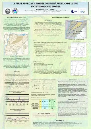
Understanding hydrologic changes: application of the VIC model Vimal Mishra Assistant Professor Indian Institute of Technology (IIT), Gandhinagar vmishra@iitgn.ac.in https://sites.google.com/site/vimalmishraiitgandhinagar/ 1
Climate Change and Water Resources • Water is in the eye of climate management storm (IPCC, 2007) • Global warming and related climate changes are expected to present significant challenges over the next century • The impacts of climate change on water resource: a) Quantity- less or more b) Extremes – droughts and floods c) Frequency- intensified challenges 2
Science Questions • How have hydrologic conditions associated with soil moisture, evapotranspiration, groundwater, snow cover, and streamflow changed during the last 50 years? • How will water availability and water storage change in space and time under the projected future climate change? • Will hydrologic extremes be more frequent, wide spread, and more intense? s3
Key Impacts • Surface water [ streamflow, soil moisture, ET, Snow and Glaciers levels of reservoirs/lakes] • Groundwater [recharge rates, groundwater table] • Droughts [ indicators, areal extents, severity, and frequency] • Floods [return levels, flash flooding, damage to infrastructure] • Key areas [ Agriculture, Hydropower, Water Storage and Water Availability] 4
Hydrologic Modeling of Climate Change Impacts • Climate forcing (spatial resolution) • Data for calibration and evaluation (groundwater, surface water, water quality) • Land use/land cover projections • Cropping systems/patterns and irrigation demands • Water management and reservoir operations • Evaluation of uncertainty 5
THE VARIABLE INFILTRATION CAPACITY (VIC) MODEL Liang et al. (1994), Cherkauer et al., 2003 Mishra et al., 2010; Mishra and Cherkauer, 2010
The VIC model: Main Features • The VIC model (Liang et al. 1994) is a large scale semi-distributed model • It has several features that are common to other land surface models (LSMs) used in the global climate models (GCMs) • The land surface is modeled using the large ( > 1 km) flat grid cells • Sub-grid heterogeneity (elevation, land cover) is handled using statistical distributions 7
Meteorological Forcing • Can use any combination of daily or sub-daily meteorogolical forcings, from point observations, gridded observations, or reanalysis fields • At minimum, VIC requires daily {precipitation, max/min air temperature, and wind speed} • If incoming shortwave radiation or humidity are not supplied as forcings, VIC can estimate them via the algorithms of Kimball et al. (1997), Thornton and Running (1999), and Thornton et al. (2000) • VIC can disaggregate daily forcings to sub-daily as needed (further details available in Bohn et al., 2012b) 8
Running the VIC Model • Basin delineation • Prepare input files ( meteorological data, soil, vegetation parameters) • Compilation of code (written in C language) • Running VIC for the basin of interest • Output variables at each grid cell • Use Routing model to rout flow at the location of interest 9
Representation of Various Components • Lakes and Wetlands • Irrigation • Reservoirs • Groundwater • Cold Season Process ( soil frost, snow, and glaciers) Applications: • Monitoring and Prediction • Climate Change Impacts • Impacts of Land Cover and Land Use • Human Modifications ( Irrigation, reservoirs etc)
Groundwater Conditions Colorado Basin Rosenberg et al., 2012 11
Irrigation and Reservoir Change in Evapotranspiration (ET) Irrigated Area Haddland et al. (2007) 12
Application: Drought Monitoring and Prediction Mishra (in review)
Application: Retrospective Analysis Mishra et al. (in revision)
Application: Streamflow Forecasting Role of Data Assimilation in real time forecast Observed No Assimilation With Assimilation Mishra et al. (2011)
Climate Change: how reliable are the GCMs? Ensemble Mean Percentage Bias (1961-1990) Precipitation Temperature Mishra (in preparation)
HOW RELIABLE ARE GCMS? Mishra (in preparation)
Model Simulations Using Bias Corrected Data Bias Corrected and Spatial Downscaling (BCSD) Approach (Wood et al., 2002; 2004) Monsoon Season (JJAS) 18
Hydrologic Impacts of Climate Change Multimodel Ensemble Mean Change for the Near (2010-2039)
Hydrologic Impacts of Climate Change Multimodel Ensemble Mean Change for the Near (2010-2039)
Hydrologic Impacts of Climate Change Multimodel Ensemble Mean Change for the Mid (2040-2069)