Download

1 / 39
430 likes | 705 Views
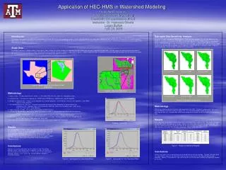
Application of HEC-HMS for Hydrologic Studies. Texas A&M University Department of Civil Engineering CVEN689 – Applications of GIS in CE Instructor: Dr. Francisco Olivera Logan Burton 3/14/03. Outline. HMS and GIS Project Overview Challenges Solutions Methodology Results. HEC-HMS.

E N D
Application of HEC-HMS for Hydrologic Studies Texas A&M University Department of Civil Engineering CVEN689 – Applications of GIS in CE Instructor: Dr. Francisco Olivera Logan Burton 3/14/03
Outline • HMS and GIS • Project Overview • Challenges • Solutions • Methodology • Results
HEC-HMS • HMS Hydrologic Modeling System • Developed by the U.S. Army Corp of Engineers • A numerical model that can help predict runoff volumes, peak flows, and timing of flows by simulating the behaviors of the watersheds, channels, and reservoirs.
HEC-HMS Advantages • Can be applied to a variety of watersheds with different shapes, sizes and characteristics • Graphical User Interface makes the program user friendly • Software is public domain - Can be downloaded from HEC website at no cost
HMS Applications • Urban Flooding This project • Flood Frequencies • Flood-loss reduction • Flood warning systems • Reservoir Design • Other Environmental studies *From HEC-HMS Applications Guide, Dec. 2002
Advantages of Using GIS in Hydrologic Studies • Effective and efficient delineation of watersheds and streams • Quick extraction of watershed and stream parameters • DEMs can define the drainage basin boundaries
Urban Flooding • What is an Urban Flooding Study? A hydrologic study in an urban area to analyze or predict flooding problems. Common Characteristics • Short response times • Drainage systems in place • Development plays large role watershed behavior
Scope of Urban Flooding • Model and analyze existing basin • Edit model to simulate urbanization • Analyze new model to help predict impact of future development
Salado Creek Basin • Location: Bexar County San Antonio, TX San Antonio
Required Information • Peak Flows • Runoff Volume • Flow Timing • Peak Stage* • Floodplain Delineation* *HEC-RAS is used to calculate these All of this information is required for current and future development
Required Data for Analysis • DEM (30 meter) • NHD files • USGS Gauging Stations • HUC boundaries Optional: DRG topographic map
GIS Challenges • Gathering Data – different sources
GIS challenges • Managing and Organizing Data - Different Sources = Different Projections - Very Important to keep the metadata with the downloaded files • These problems can be easily solved by using the available tools and extensions
Extensions and Tools • CRWR-Vector* - project vector data • ArcInfo – project raster data • CRWR-Raster* - merge grids • CRWR-PrePro* - data pre-processor • HEC-GeoHMS could have been used in place of PrePro *Programs written by Dr. Francisco Olivera
Projecting Shapefiles • CRWR-Vector is used to project shapefiles (points, lines, polygons) • Use the project tool in the pull down menu
CRWR-PrePro • Can be downloaded from Dr. Olivera’s website • Predecessor to GeoHMS
HEC-GeoHMS • Can be downloaded from HEC website • Menu is very similar to CRWR-Prepro
Methodology • Projected all data to UTM27 – Zone 14 • Ran CRWR-PrePro to delineate watershed - Problem appeared
Problem • PrePro requires that stream lengths be greater than 1 cell • Cell size is 28.85 m
Solution: Step 1 • Add point theme
Step 2 • Add “Elevation” Field to attribute table
Step 3 • Convert the point theme to a grid
Step 4 • Merge original DEM to new grid using CRWR-Raster
Step 5 • Re-run CRWR-PrePro with fixed grid
Process Data • Calculate Attributes • HMS Schematic
HMS Components • Basin Model • Meteorological Model • Control Specifications
Basin Model • Imported from ArcView
Basin Characteristics • Initial/Constant Loss Rate • Initial loss = 0.39 in • Constant loss = 0.20 in - From local soil parameters • Before Development: Northern basins – 10-25% imperviousness Southern basins - 75% imperviousness - HMS Reference Manual
Meteorological Model Input from TxDot Hydraulic Manual for Bexar County
Control Specifications • Rainstorm of October 17-18, 1998 was used
Calibration USGS Fact Sheet FS-147-99
Effects of Urbanization • After Development: Entire basin model = 75% imperviousness
Results Undeveloped Basin Developed Basin • Development increased flow 10,000 cfs (16%) at this gauging station
Floodplains • Input channel geometry and roughness data into HEC-RAS • Import peak flows from developed basin into HEC-RAS to calculate water surface elevations and floodplains
Questions? SaladoCreek