Download
1 / 17
170 likes | 316 Views
How Often Does Eye Formation Coincide with Rapid Intensification?. Jonathan Vigh NCAR Advanced Study Program Earth System Laboratory 1:30 PM Nov 16, 2011 Riehl Room 8 th Semiannual Joint CSU/NCAR/NOAA Hurricane Workshop Fort Collins, Colorado

E N D
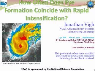
How Often Does Eye Formation Coincide with Rapid Intensification? Jonathan Vigh NCAR Advanced Study Program Earth System Laboratory 1:30 PM Nov 16, 2011 Riehl Room 8th Semiannual Joint CSU/NCAR/NOAA Hurricane Workshop Fort Collins, Colorado This presentation has been modified somewhat from what was presented following the feedback received. Hurricane Rina near the time of eye formation. NCAR is sponsored by the National Science Foundation
Elapsed time for eye development from the tropical storm stage • Majority of storms form eyes within 2 days of becoming a TS • Relatively fewer # of storms take much longer to form their eyes • Physical interpretation • Storms form an eye as soon as they are able to • Many storms undergo genesis under environmental favorable conditions • -> the development of an eye happens sooner rather than later • In this view, eye formation can be considered the final stage of the genesis process
Methdology • Rapid Intensification (RI25) onset defined here as a 25-kt increase in Best Track intensity over a 24-hr period • Note: this is lower than some other thresholds. Standard threshold is normally 30 kt. • End of RI25 is set at the last time point that the intensification rate criterion is satisfied • Time of eye formation is taken to be the first fix in which an aircraft observed an eye • Eye formation cases stratified by longevity and persistence of the initial eyes
Frequency of RI25 • 138 out of 310 TCs in Atlantic underwent RI25 • 44.5% of all TCs (including depressions) • Out of 70 eye-forming storms in well-observed aircraft sample, 52 underwent RI25 (74%) • 9196 non-missing BT vmax points in the data set • 613 were during RI25 periods (6.7%)
IVAN vmax change during RI: 65 length of RI period: 48.0 • (0) Beginning of RI period #0: IVAN 200409041200 vmax = 50 • (0) IVAN 200409041200 50 • (0) IVAN 200409041800 55 • (0) IVAN 200409050000 60 • (0) IVAN 200409050600 65 • (0) IVAN 200409051200 85 • (0) IVAN 200409051800 110 • (0) IVAN 200409060000 115 • (0) IVAN 200409060600 110 • (0) IVAN 200409061200 110 • (0) End of RI period: #0: IVAN 200409061200 vmax = 110 • (0) • (0) IVAN vmax change during RI: 30 length of RI period: 30.0 • (0) Beginning of RI period #1: IVAN 200409070000 vmax = 90 • (0) IVAN 200409070000 90 • (0) IVAN 200409070600 95 • (0) IVAN 200409071200 100 • (0) IVAN 200409071800 105 • (0) IVAN 200409072100 110 • (0) IVAN 200409080000 115 • (0) IVAN 200409080600 120 • (0) End of RI period: #1: IVAN 200409080600 vmax = 120 • (0) • (0) IVAN vmax change during RI: 25 length of RI period: 24.0 • (0) Beginning of RI period #2: IVAN 200409101800 vmax = 120 • (0) IVAN 200409101800 120 • (0) IVAN 200409110000 135 • (0) IVAN 200409110300 130 • (0) IVAN 200409110600 130 • (0) IVAN 200409111200 125 • (0) IVAN 200409111800 145 • (0) End of RI period: #2: IVAN 200409111800 vmax = 145 • (0) • (0) IVAN vmax change during RI: 25 length of RI period: 24.0 • (0) Beginning of RI period #3: IVAN 200409221200 vmax = 25 • (0) IVAN 200409221200 25 • (0) IVAN 200409221800 30 • (0) IVAN 200409230000 35 • (0) IVAN 200409230600 35 • (0) IVAN 200409231200 50 • (0) End of RI period: #3: IVAN 200409231200 vmax = 50
Stratified by Eye Formation Type Case Type # of cases # undergoing RI • No aircraft data 127 30 24% • No observed eye 76 23 31% • Insufficient data 9 8 89% • Eye already present 28 25 89% • Rapid dissipation 17 9 53% • Intermittent formation 24 14 58% • Delayed formation 12 12 100% • Sustained formation 17 17 100% • Open warm spot 176 104 • Closed warm spot 146 100 • First IR eye 116 91 • Persistent eye 80 70 • Strong eye 40 40
Statistics for the 70 eye-forming cases • RI25 onset occurred in 52 of the 70 eye-forming storms (74%) • RI25 onset occurred BEFORE eye formation in 44 storms (84%) • RI25 onset occurred AFTER eye formation in 8 storms (16%) • RI25 ended BEFORE eye formation in 13 storms (25%) • RI25 ended AFTER eye formation in 39 storms (75%)
Conclusions • RI25 often begins at the depression or minimal storm stage • Eye formation often occurs during a period of rapid intensification at this lower threshold • RI prediction methods based on TS may need to be revised to include depressions • Results are consistent with Kaplan et al 2009 • Their work shows that the higher thresholds of RI (RI30 and RI35) begin at higher intensities more typical of the median intensity at eye formation.
Next Steps • Expand analysis to RI30 and RI35 • Also analyze intensification trends about simple intensity thresholds • Determine role of environmental influence in eye formation and intensification • Does the eye form merely because the storm is intensifying? • Or does it assist in the intensification? • Is it a stochastic (random) process – or a manifold attractor of the system? • Examine Radius of Maximum Winds (RMW) • What controls the RMW? • Internal dynamics? • Storm environment? • Why do some storms intensify rapidly without contracting? • Does the storm’s initial structure determine an upper bound on the maximum rate that it can intensify at?
Comments and Questions The NESL Mission is: To advance understanding of weather, climate, atmospheric composition and processes; To provide facility support to the wider community; and, To apply the results to benefit society. NCAR is sponsored by the National Science Foundation