Download
1 / 1
10 likes | 153 Views
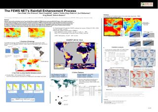
3B42 Dek X (TRMM). Average 3B42 X. FCLIM dek X. Master station, first priority. 10Km radius. support station, lower priority. Estimate value for a pixel. IR Dek X. Average IR X. Estimate rainfall value for each pixel. Select predictors. Define region. Radius=150km. TRMM % anomaly.

E N D
3B42 Dek X (TRMM) Average 3B42 X FCLIM dek X Master station, first priority 10Km radius support station, lower priority Estimate value for a pixel IR Dek X Average IR X Estimate rainfall value for each pixel Select predictors Define region Radius=150km TRMM % anomaly IR % anomaly FCLIM (Climatology) Satellite rainfall Latitude elevation Extract value of predictors at each station location. Create a simple linear model, and use the parameters to estimate the value at a given pixel The FEWS NET’s Rainfall Enhancement Process We first select define window of interest, good spatial coverage with stations and similar topography. Select best predictors for the region of interest. Search for available stations within a radius (1.5 to 5 degrees) Chris Funk1, Pete Peterson2, Marty Landsfeld2, Andrew Verdin, Diego Pedreros1, Joel Michaelsen2, Greg Husak2, Bolesto Romero2 Rainfall values mm/pent Validation: .A- Comparison of the different stages of the rainfall improving process, TRMM, FTIP and FTIP plus available station. 1 U.S. Geological Survey (USGS) Earth Resources Observation and Science (EROS) Center, Sioux Falls, SD. FEWS NET . 2Climate Hazard Group, UCSB/Geography dpt. 3Food Security Early Warning System (FEWS NET). 4UCSB Geography Dpt. 5Universidad de Costa Rica. Abstract: . FEWS NET uses rainfall accumulations from the Tropical Rainfall Measuring Mission (TRMM) estimates produced by NASA (0.25 degree, c.25 km, spatial resolution) to evaluate available precipitation for rain fed agriculture. A preliminary comparison of TRMM and independent stations reveals large differences between the two (Figure 1). The spatial resolution of TRMM estimates is particularly a concern, given the narrow land mass and the topographic dynamics in regions such as Central America and the Caribbean. In response to both the low correlation and coarse resolution of the TRMM estimates, FEWS NET sought to enhance satellite estimated rainfall by complementing it with higher spatial resolution climatologic fields along with other satellite and ground station data. FTIP plus available station data results in the Improved Rainfall Estimate (IRE) • B- Climate Hazards IR Precipitation (CHIRP): combines two sources of IR data, B1 (1981 – 2008) and CCP– IR (2000 – present). • build monthly models of rainfall trained on TRMM-V7 • derive coefficients a and b, such that rain rate = a * CCD + b (IRP) • where CCD is the percentage of observation where IR temp < threshold • CHIRP (1981-present) = FCLIM * (IRP %normal) FTIP pentad (5-day) accumulations Satellite Estimated Rainfall from the Tropical Rainfall Measuring Mission (TRMM), July 21-31, 2009. The FTIP (FEWS NET–TRMM-IR-Precipitation), July 21-31, 2009. CHIRP 2012.10.6 0.05, global, unbiased, rainfall pentad (mm) with 2 days lag. 1- Develop a Climatology The FEWS Climatology (FCLIM): derived from station averages combined with rainfall predictors such as topography (Elevation, slope, aspect) and geography (lat/lon, proximity to coast). B – Relationship between rainfall and Elevation FCLIM February 3- Station Database: 2- Use Fclim to unbias Satellite Estimated rainfall Daily Precipitation (from 1832)number of stations = 120,898number of records = 955,887,417 Monthly Precipitation (from 1697)number of stations = 142,384number of records = 45,748,550 A- FCLIM- TRMM – IR Precipitation (FTIP): combines… The FTIP combines percent anomalies from TRMM and IR, and multiply it by FCLIM Sources: Data were prioritized based on their origins. Data Sources including national met services, GHCN, GSOD, GTS and others References • Funk, C., G. Husak, et al. (2007). "Third generation rainfall climatologies: satellite rainfall and topography provide a basis for smart interpolation, Crop and Rangeland Monitoring Workshop.“ • Verdin, J. and R. Klaver (2002). "Grid cell based crop water accounting for the Famine Early Warning System " Hydrological Processes 16: 1617-1630. • Huffman, G. J., Adler, R. F., Bolvin, D. T., Gu, G., Nelkin, E. J., Bowman, K. P., Hong, Y., Stocker, E. F. & Wolff, D. B. 2007: The TRMM Multisatellite Precipitation Analysis (TMPA): Quasi-Global, Multiyear, Combined-Sensor Precipitation Estimates at Fine Scales. Journal of Hydrometeorology 8, 38-55. • Janowiak J. E., R. J. J., and Y. Yarosh. 2001: A Real-Time Global Half-hourly Pixel-Resolution Infrared Dataset and Its Applications. Bull. Amer. Meteor. Soc. 82, 205-217. Definitions: • FCLIM: FEWS Climatology – a climatological field calculated using multivariable regression • TRMM: Tropical Rainfall Measurement Mission satellite-derived rainfall estimate • TRMM-RT: real time TRMM • FTIP: FEWS NET-TRMM-IR-Precipitation derived from TRMM, IR and FCLIM. • CHIRP: Climate Hazards Group IR Precipitation Oct 2012