Download
1 / 18
191 likes | 488 Views
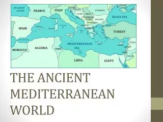
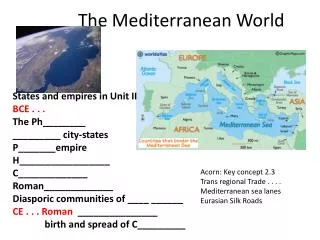
12. 13. Page 13. The Geography of the Mediterranean World. Lesson 3. Lesson 3: The Geography of the Mediterranean World. R. 13. O BJECTIVES:. I can locate the major physical features of the Mediterranean region.

E N D
12 13
Page 13 The Geography of the Mediterranean World Lesson 3
Lesson 3: The Geography of the Mediterranean World R 13 OBJECTIVES: • I can locate the major physical features of the Mediterranean region. • I can describe the describe key geographic and political features of medieval Europe. • I can explain how geography affected selected aspects of life in medieval Europe.
Lesson 3: The Geography of the Mediterranean World L 12 WARM-UP List as many features of Mediterranean region as you can.
Lesson 3: The Geography of the Mediterranean World GEOGRAPHY CHALLENGE With a partner, you will identify key geographic and political features of medieval Europe and describe how geography affected selected aspects of life in medieval Europe.
Lesson 3: The Geography of the Mediterranean World L 12 GEOGRAPHY CHALLENGE STEP 1 Create a CHART. QUESTION 1 QUESTION 5 QUESTION 6 QUESTION 2 QUESTION 3 QUESTION 7 QUESTION 4 QUESTION 8
Lesson 3: The Geography of the Mediterranean World R 13 GEOGRAPHY CHALLENGE STEP 2 Attach the Map of the Mediterranean.
Lesson 3: The Geography of the Mediterranean World L 12 GEOGRAPHY CHALLENGE STEP 3 Read pages 4 and 5 in The Medieval World and Beyond. STEP 4 Complete the eight Challenge Questions. Answereach questionwith complete sentences in the chart. NOW, get with your “Roman” partner.
12 13 Lesson 3 THE GEOGRAPHY OF THE MEDITERRANEAN WORLD WARM-UP List as many features of the Mediterranean region as you can. • OBJECTIVES: • I can locate the major features of the Mediterranean region. • I can describe the key geographical and political features of medieval Europe. • I can explain how geography affected selected aspects of life in medieval Europe. ? ? WRAP UP What do you now know about medieval Europe that you didn’t know before? What information from this map do you think will be most important in our study of medieval Europe? What questions about medieval Europe did this activity raise? ?
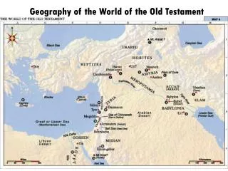
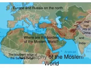
Lesson 3: The Geography of the Mediterranean World Medieval Europe Question 1 The continent located south of Europe is Africa. What continent is located south of Europe? Label the continent of Asia. ASIA
Lesson 3: The Geography of the Mediterranean World Medieval Europe Question 2 Label the Atlantic Ocean, North Sea, Mediterranean Sea, and Black Sea. In what ways might these bodies of water have influenced life in medieval Europe? These bodies of water allowed traders to move goods throughout Europe more easily but also mode settlements along coastal areas vulnerable to attack by invaders. North Sea ASIA Atlantic Ocean Black Sea Mediterranean Sea
Lesson 3: The Geography of the Mediterranean World Medieval Europe Question 3 Large cities may have been located along rivers because it was easier in medieval Europe to travel and ship goods by water. Label the Seine, Thames, and Danube Rivers. Why do you think large medieval cities were located along rivers? North Sea Thames ASIA Atlantic Ocean Seine Danube Black Sea Mediterranean Sea
Lesson 3: The Geography of the Mediterranean World Medieval Europe Question 4 The mountains acted as barriers to travelers and traders, and as protection. What effect do you think these mountains had on life in medieval Europe? Label the Pyrenees, Alps, and Carpathian Mountains. North Sea Thames ASIA Atlantic Ocean Seine Danube Carpathian Mts Alps Pyrenees Black Sea Mediterranean Sea
Lesson 3: The Geography of the Mediterranean World Medieval Europe Question 5 The fall of the Roman Empire created political disunity. Some invaders set up new kingdoms, while in other areas the Catholic Church or political leaders in Constantinople worked to maintain order. Each of these areas had a different leader. Why do you think Europe had no single governmentduring the Middle Ages? Label England, France, the Papal States,the Holy Roman Empire, and the Byzantine Empire. North Sea England Thames Holy Roman Empire ASIA Atlantic Ocean Seine Danube Carpathian Mts France Alps Pyrenees Papal States Black Sea Mediterranean Sea Byzantine Empire
Lesson 3: The Geography of the Mediterranean World Medieval Europe Question 6 These cities are all located next to bodies of water, which allowed travelers and traders to reach them easily. What is common about the locations of all of these cities? How might that have affected life in medieval Europe? Label the cities of Constantinople, Hamburg, London, Paris, and Rome. North Sea England Hamburg Thames Holy Roman Empire ASIA London Atlantic Ocean Seine Paris Danube Carpathian Mts France Alps Pyrenees Papal States Black Sea Constantinople Rome Mediterranean Sea Byzantine Empire
Lesson 3: The Geography of the Mediterranean World Medieval Europe Question 7 In this climate zone, winters are cool and summers are warm, it rains moderately throughout the year, and clouds, fog, and drizzle are common. Soils are generally heavy and sticky due to high levels of clay. Color the areas of Europe in the “humid oceanic”climate zone green. Medieval farmers used plows to break up the soil here. They rotated their crops (e.g., planting wheat or rye in the fall, oats or barley in the spring). What does this tell you about the climateand soil in this zone? North Sea England Hamburg Thames Holy Roman Empire ASIA London Atlantic Ocean Seine Paris Danube Carpathian Mts France Alps Pyrenees Papal States Black Sea Constantinople Rome Mediterranean Sea Byzantine Empire
Lesson 3: The Geography of the Mediterranean World Medieval Europe Question 8 In this climate zone, summers are warm to hot while winters are mild and rainy. Soils in this area tend to be sandy and drain well. Color the areas of Europe in the “subtropical dry summer” climate zone orange. In this zone, medieval farmers were able to grow a host of crops, such as wheat, olive trees, and wine grapes. What does this tell you about the climateand soil in this zone? North Sea England Hamburg Thames Holy Roman Empire ASIA London Atlantic Ocean Seine Paris Danube Carpathian Mts France Alps Pyrenees Papal States Black Sea Constantinople Rome Mediterranean Sea Byzantine Empire
Lesson 3: The Geography of the Mediterranean World L 12 WRAP-UP What do you now know about medieval Europe that you didn’t know before? What information from this mapdo you think will be most important in our study of medieval Europe? What questions about medieval Europe did this activity raise?