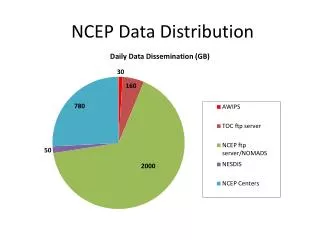
NCEP Data Reanalysis
NCEP Data Reanalysis. 陳漢卿. Data analyses. Use the data available for the original operational NCEP analyses. (available from 1962) Add other datasets to capture the older data from 1948. Global rawinsonde data. NCEP GTS data with upper-air observation from 1962 is main data source.


NCEP Data Reanalysis
E N D
Presentation Transcript
Data analyses • Use the data available for the original operational NCEP analyses. (available from 1962) • Add other datasets to capture the older data from 1948.
Global rawinsonde data • NCEP GTS data with upper-air observation from 1962 is main data source. • The count of significant level winds was low from August 1989 to September 1991. ECMWF Supplied data to fill the gap
COADS surface marine data • First release in 1983 & updated recently. • Include ship, fixed buoys, drifting buoys, pack-ice buoys, near surface data from ocean station reports, and other data. • An update for 1980-93 has been completed.
Aircraft data • Aircraft data is available from NCEP GTS source starting in 1962. • Additional data from several source: • Data from New Zealand (Feb.1984-June 1988) • GARP Atlantic Tropical Experiment (GATE)(1974) • First GARP Global Experiment (FGGE)(1979) • USAF reconnaissance data (start from1947) • Tropical Wind Energy Conversion Reference Level Equipment (TWERLE)(July1975-Aug.1976)
Surface land synoptic data • Global GTS data are available starting from 1967 from air force or NCEP. • The data coverage is good from 1949.
Satellite sounder data • Be available for the following periods: • SIRS IR sounder 1969 – 1971 • SIRS on early NMC tapes 1969 – 1992 • VTPR IR sounder 1972 – 1979 • TOVS sounder 1978 – present • HIRS data test system 1975 – 1976 • First phase of reanalysis use the TOVS data. • Second phase of reanalysis use 3D assimilation of variances.
SSM/I surface wind speeds • Special Sensing Microwave/Imager became available in 1987 . • At NCEP, the assimilation of surface winds became operational in 1993. • Results in wind speeds closer to buoys wind speed and with better coverage under cloudy than present operational algorithm used at NCEP. • Do not use SSM/I surface wind speeds data at first phase of reanalysis. Use SSM/I surface wind speeds & precipitable water data at 2nd phase of reanalysis.
Data preprocessor • The purpose of the preprocessing reanalysis is to reformat the data coming form many different sourcesinto uniform BUFR and preprocess 1 or more year at a time before actual reanalysis. • Preprocessor allows human monitor can take corrective action before actual reanalysis.
Satellite data • A special satellite TOVS soundings data monitoring system has been developed. • Data in grid boxes of 10°x10°. • The average in the box, the variance in the box, and the absolute value of tendency of the box average are compared with a climatology.
Climatological QC test of data • The automatic monitoring system developed for the reanalysis output is based on climatological tests with 3D statistics computed. • Allow human monitors to check for unusual data before the monthly reanalysis.
Boundary field • SST: Reynolds reanalysis for 1982. • Snow cover: NESDIS weekly analyses. • Sea ice: Derived from SMMR/SMI data. Incorporated into SST analysis (SST<-1.8℃considered sea ice) • Albedo: Matthews(1985) • Soil wetness: Use the Pan & Mahrt (1987) soil model • Roughness length: From SiB • Vegetation: From SiB.