Comprehensive Overview of IRI's Data Tools and Collections for Geospatial and Environmental Research
Explore the extensive capabilities of the IRI Data Library, featuring a variety of datasets and specialized data tools. This overview covers multidimensional and variable data, calculations, and virtual variables. Utilize resources such as OPeNDAP, THREDDS, and formats like netCDF and GRIB for your data analysis. Access geolocated data by latitude/longitude, entity, and vector objects, complemented by visual tools including maps, images, and graphs. Enhance your research with our user-friendly data viewer and data collection tools, perfect for environmental studies and GIS applications.

Comprehensive Overview of IRI's Data Tools and Collections for Geospatial and Environmental Research
E N D
Presentation Transcript
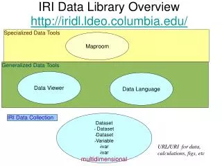
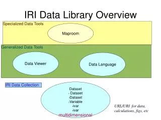
Dataset • Dataset • Dataset • Variable • ivar • ivar multidimensional IRI Data Library Overview Specialized Data Tools Maproom Generalized Data Tools Data Viewer Data Language IRI Data Collection URL/URI for data, calculations, figs, etc
spreadsheets GRIB netCDF images binary shapefiles Database Tables queries Servers OPeNDAP THREDDS images w/proj IRI Data Collection Dataset • Dataset • Dataset • Variable • ivar • ivar Calculations “virtual variables” images graphics descriptive and navigational pages Tables Clients OPeNDAP THREDDS Data Files netcdf binary images OpenGIS WMS/WCS IRI Data Collection GIS “geolocated by lat/lon” “geolocated by entity” “geolocated by vector object”