Download

1 / 15
170 likes | 510 Views
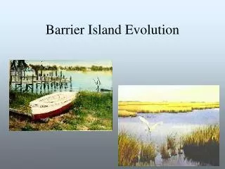
Tidal Inlet Formation Barrier Island Breaching. Shinnecock Inlet, 1938. Tidal Inlet Formation Barrier Island Breaching. Pikes Inlet, 1992. Beach Morphology and Sediments.

E N D
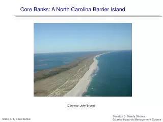
Tidal Inlet Formation Barrier Island Breaching Shinnecock Inlet, 1938
Tidal Inlet Formation Barrier Island Breaching Pikes Inlet, 1992
Beach Morphology and Sediments Beach Morphology: reflects the composition of its sediments and physical process of waves, currents, and sediment transport The Beach: is usually defined as an accumulation of unconsolidated sediment (sand, gravel, cobbles, and boulders) extending from the mean low-tide line to some physiographic change such as a sea cliff or dune field or the point where permanent vegetation is established. Shoreline: the line of demarcation between the water and the exposed beach.
Terminology used for Waves and Currents Nearshore Zone: region extending seaward from the shoreline to just beyond the point where waves break. Offshore: relatively flat region beyond the breaker zone extending out to the edge of the continental shelf. Breaker Zone: the nearshore region in which waves arriving (propagating) from the offshore become unstable and break. Depending on incident wave conditions and bottom slope this region could appear more like a line. .
Terminology used for Waves and Currents Surf Zone: the nearshore region in which bore-like waves occur following wave breaking. This region extends from the breaker zone to the swash zone. Swash Zone: the portion of the shore or beach face alternately covered by the run-up of the wave swash and exposed by the backwash.
Terminology used for Nearshore Morphology Littoral Zone: term used to denote the zone extending across the exposed beach into the water to a depth at which the sediment is less actively transported by surface waves, (depth of closure, 10-20m). Backshore: The zone of the beach profile extending landward from the sloping foreshore to the point of development of vegetation or change in physiography (dune field, cliff etc.). Berm: the nearly horizontal portion of the beach or backshore formed by the deposition of sediments by waves. Some beaches have more than one berm at slightly different levels separated by a scarp.
Terminology used for Nearshore Morphology Scarp: A nearly vertical escarpment cut into the beach profile by wave erosion. Generally scarps are less than a meter. Beach Face: The sloping nearly planar section of the beach profile below the berm, which is normally exposed to the swash of waves. Foreshore: the sloping portion of the beach profile lying between a berm crest and the demarcation of the low-water backwash, extends slightly seaward of the beach face region.
Terminology used for Nearshore Morphology Inshore: The zone of the beach profile extending seaward from the foreshore to just beyond the breaker zone. Longshore Bar: An underwater ridge of sand running roughly parallel to the shore, sometimes continuous over large distances, at other time having roughly even breaks along its length. It may become exposed during low tide, often several longshore bars are present in different water depths. During large storms waves will break on the outer bars which are not visible during normal conditions. Longshore Trough: elongated depression extending parallel to the shoreline and any longshore bars that are present.
Dominant Factors Controlling Mean Grain Size on Beaches Sediment Source: for New York, bluffs (glacial till), shelf sands. Wave Energy: wave energy variations from Montauk to NY Harbor. General Offshore Slope: steep slopes (coarse material), shallow slopes (fine material).
General Relationships Between Settling Velocity – Sediment Removal Bagnold 1963 Autosuspension: grains of a certain size will remain permanently in suspension for a given condition and be transported away from the beach (crosshore or longshore). Ws: settling or fall velocity u: maximum horizontal orbital velocity due to waves (related to H and T) S: beach slope (3o is a 1 on 20 slope or 0.05) .
General Relationships Between Settling Velocity – Sediment Removal Dean 1973/1983 Relates transport to height of suspension and wave period. h: local water depth : percentage of local water depth Maximum suspension is occurring in the most turbulent regions of the beach breaker zone and surfzone. Using relationships between the water depth and wave height the equation can be modified to:
Example S = 3o, 0.05 u = 25 cm/sec Ws < 1.25 cm/sec /h = 10 cm T = 10 sec Ws < 1 cm/sec