Download
1 / 13
130 likes | 234 Views
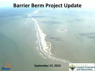
Chenier Ronquille Barrier Island Restoration Project (BA-76). Kenneth Bahlinger CPRA- Project Management Division May 8, 2014. committed to our coast. committed to our coast. Introduction. Located in Plaquemines Parish

E N D
Chenier Ronquille Barrier Island Restoration Project (BA-76) Kenneth Bahlinger CPRA- Project Management Division May 8, 2014 committed to our coast committed to our coast
Introduction • Located in Plaquemines Parish • CWPPRA Project (NOAA/NMFS) Authorized for Engineering and Design in 2010 • Designed by Coastal Planning and Engineering (CB&I) • 95% Complete Design Coastal Protection and Restoration Authority of Louisiana
Project Background • Shoreline erosion, interior wetland loss, overwash, and breakup. • Eroding 38 ft/yrin 1988 to 2006 • Rate accelerated by storms in 2005 and 2008 Coastal Protection and Restoration Authority of Louisiana
Fill Area: Plan View Beach and Dune Back Marsh Access Channel Temporary Disposal Area Discharge Area Monument Primary Containment Sand Fence Coastal Protection and Restoration Authority of Louisiana
Estimated Bid Quantities Coastal Protection and Restoration Authority of Louisiana
Pumping Distances 2 miles • 4 Permitted Areas • 3 Sand Sources • 2 Marsh Sources • Average Pumping Distance: ~ 2 miles Coastal Protection and Restoration Authority of Louisiana
Borrow Areas: Plan View and Cross-Sections Sand Sand with Overburden Marsh Material S1 & S2: -8 < Sand Cut < -16 ft. NAVD 88 D1: -18 < Sand Cut < -26 ft. NAVD 88 D1: -10 < Marsh Cut < -18 ft. NAVD 88 Quatre Bayou: -10 < Marsh Cut < -18 ft. NAVD 88 Coastal Protection and Restoration Authority of Louisiana
Fill Area: Cross-Sections • Dune Height: +8.0 ft. NAVD88 • Marsh Fill Height: +2.5 ft. NAVD88 • Containment Dike Height: +5.0 ft. NAVD88 • Access Channel Depth: -7.0 ft. NAVD88 Coastal Protection and Restoration Authority of Louisiana
Special Conditions 1: Pipelines Plains Pipeline Columbia Pipeline Coastal Protection and Restoration Authority of Louisiana
Fill Area: Access Dredging Coastal Protection and Restoration Authority of Louisiana
Special Conditions 2: Endangered Species Piping Plover Sea Turtles Migratory Birds Coastal Protection and Restoration Authority of Louisiana
Project Status • DNR/OCM Consistency and USACOE Permit approved • Land agreements to be completed • Oyster leases to be surveyed, appraised, and acquired • Did NOT receive CWPPRA Phase II construction funding • Anticipated funding through NRDA • NOAA/NMFS to bid for construction Coastal Protection and Restoration Authority of Louisiana
QUESTIONS??? Coastal Protection and Restoration Authority of Louisiana