Download
1 / 48
500 likes | 996 Views
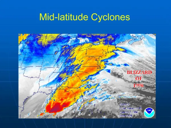
Mid-Latitude Cyclones and Fronts. Lecture 12 AOS 101. Homework 4. COLDEST TEMPS. GEOSTROPHIC BALANCE. Homework 4. L. FASTEST WINDS. Rising Air. Consider an air parcel rising through the atmosphere The parcel expands as it rises

E N D
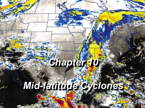
Mid-Latitude Cyclones and Fronts Lecture 12 AOS 101
Homework 4 COLDEST TEMPS GEOSTROPHIC BALANCE
Homework 4 L FASTEST WINDS
Rising Air • Consider an air parcel rising through the atmosphere • The parcel expands as it rises • The expansion, or work done on the parcel causes the temperature to decrease • As the parcel rises, humidity increases and reaches 100%, leading to the formation of cloud droplets by condensation
Rising Air • If the cloud is sufficiently deep or long lived, precipitation develops. • The upward motions generating clouds and precipitation can be produced by: • Convection in unstable air • Convergence of air near a cloud base • Lifting of air by fronts • Lifting over elevated topography
Lifting by Convergence • Convergence exists when there is a horizontal net inflow into a region • When air converges along the surface, it is forced to rise
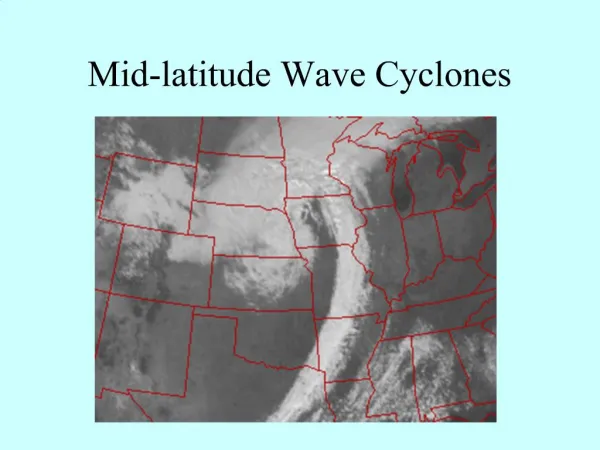
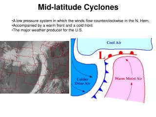
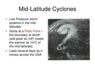
Background on Cyclones • A cyclone is: An area of low pressure around which the winds flow counter-clockwise in the northern hemisphere, and clockwise in the southern hemisphere • Hurricane (tropical cyclone) • Mid-latitude cyclone • Today, we’ll focus on mid-latitude, or extra-tropical cyclones, which have a life cycle and frontal structures. Hurricanes, which we discussed earlier, have no fronts. http://www.wunderground.com/hurricane/history/iop4_sat.jpg
Background on Cyclones • Midlatitude cyclones are crucial in maintaining a temperature equilibrium on our planet. This is because in the northern hemisphere . . . • . . . They advect warm air northward • . . . And they advect cold air southward • This helps maintain the radiative equilibrium on our planet!
Background on Cyclones • We already know that friction near the surface causes convergence into a low pressure center and that flow is counterclockwise around the low in the N. Hemisphere. • So we end up with the cold air moving south and east and the warm air moving north and west • Likewise, lifting by convergence forces parcels upward so we get clouds and precipitation in the vicinity of the low pressure L
Background on Cyclones • The figure to the right represents a typical midlatitude cyclone: • Cold, dry air is advected eastward behind thecold front • Warm, moist air is advected north behind thewarm front • The fronts move in the direction the “teeth” point
Background on Cyclones • Definition - boundary, transition zone between two different air masses • The two air masses have different densities. Frequently, they are characterized by different temperatures and moisture contents • Front has horizontal and vertical extent • Frontal boundary/zone can be 1-100 km wide • Types of synoptic-scale fronts: • warm fronts • cold fronts • stationary fronts • occluded fronts
WarmFront • A transition zone where a warm air mass replaces a cold air mass • Drawn as a red line with red semi-circles pointing in the direction of the front’s movement
Warm Front • Again, warm air is less dense than cold air. • As the warm air moves north, it slides up the gently sloping warm front. • Because warm fronts have a less steep slope than cold fronts, the precipitation associated with warm fronts is more “stratiform” (less convective), but generally covers a greater area.
Cold Fronts • A transition zone where a cold air mass replaces a warm air mass • Drawn as a blue line with blue triangles pointing in the direction of the front’s movement
Cold Fronts • Cold air is more dense than warm air. • As the dense, cold air moves into the warm air region, it forces the warm air to rapidly rise just ahead of the cold front. • This results in deeper clouds and precipitation than we saw with a warm front. The clouds that form can be convective and can be associated with more intense precipitation and thunderstorms • Often, the precipitation along a cold front is a very narrow line of thunderstorms
Occluded Fronts • A region where a faster moving cold front has caught up to a slower moving warm front. • Generally occurs near the end of the life of a cyclone • Drawn with a purple line with alternating semicircles and triangles
Cold Occlusion • The type most associated with mid-latitude cyclones • Cold front "lifts" the warm front up and over the very cold air • Associated weather is similar to a warm front as the occluded front approaches • Once the front has passed, the associated weather is similar to a cold front • Vertical structure is often difficult to observe http://apollo.lsc.vsc.edu/classes/met130/notes/chapter11/index.html
Warm Occlusion • Cold air behind cold front is not dense enough to lift cold air ahead of warm front • Cold front rides up and over the warm front • Upper-level cold front reached station before surface warm occlusion http://apollo.lsc.vsc.edu/classes/met130/notes/chapter11/index.html
Stationary Front • Front is stalled • No movement of the temperature gradient • But, there is still convergence of winds, and forcing for ascent (and often precipitation) in the vicinity of a stationary front. • Drawn as alternating segments of red semicircles and blue triangles, pointing in opposite directions
How to Locate a Cyclone • Find the region of lowest sea level pressure • Find the center of the cyclonic (counter-clockwise) circulation
How to Locate a Cyclone • Find the region of lowest sea level pressure • Find the center of the cyclonic (counter-clockwise) circulation L
How to Locate a Front We know that we need to look for low pressure and a boundary of cold and warm air. To pinpoint the parts of our cyclone, look for specifics in the observation maps • Find the center of cyclonic rotation • Find the large temperature gradients • Identify regions of wind shifts • Identify the type of temperature advection • Look for kinks in the isobars
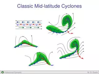
Polar Front Theory - Development and Evolution of a Wave CycloneAlso, referred to as Norwegian Cyclone Model (NCM) • The wave cyclone (often called a frontal wave) develops along the polar front • When a large temperature gradient exists across the polar front - the atmosphere contains a large amount of Available Potential Energy
NCM cont. • Northward moving warm air and southward moving cold air are forced around each other, forming a bend in the temperature gradient (b). This forms the warm front and the cold front. Now with a counter-clockwise spin, winds converge at the newly formed low pressure minimum at the center of rotation.
NCM cont. • (c)- A fully-developed cyclone is seen 12-24 hours from its inception. It consists of: • a warm front moving to the northeast • a cold front moving to the southeast • region between warm and cold fronts is the "warm sector" • central low pressure (low, which is deepening with time) • wide-spread precip. ahead of the warm front • narrow band of precip. along the cold front • Wind speeds continue to get stronger as the low deepens • The production of clouds and precip. also generates energy for the storm as Latent Heat is released http://apollo.lsc.vsc.edu/classes/met130/notes/chapter12/index.html
NCM cont. (d) - As the cold front moves swiftly eastward, the systems starts to occlude. • Storm is most intense at this stage • have an occluded front trailing out from the surface low • triple point/occlusion - is where the cold, warm, and occluded fronts all intersect http://apollo.lsc.vsc.edu/classes/met130/notes/chapter12/index.html
Final Stage (e) - the warm sector diminishes in size as the systems further occludes. • The storm has used most all of its energy and dissipates • cloud/precip production has diminished • The warm sector air has been lifted upward • The cold air is at the surface - stable situation. • The temperature contrast which drove this whole situation from the surface perspective is no longer near the center of the wave of low pressure http://apollo.lsc.vsc.edu/classes/met130/notes/chapter12/index.html
Weather associated with a typical late fall to early spring mid-latitude cyclone Figure courtesy of Jon Martin
Precipitation Around a Cyclone and its Fronts To the right is a major cyclone that affected the central U.S. on November 10, 1998. Around the cold front, the precipitation is more intense, but there is less areal coverage. North of the warm front, the precipitation distribution is more “stratiform”: Widespread and less intense. http://weather.unisys.com
Precipitation Around a Cyclone and its Fronts Again, in this radar and surface pressure distribution from December 1, 2006, the precipitation along the cold front is much more compact and stronger. North of the warm front, the precipitation is much more stratiform. Also note the kink in the isobars along the cold front!
We have all seen cyclones on weather maps, but how do we know if it will strengthen or weaken? The key to cyclone development is in the upper level flow
So let’s look at Upper Levels… Typical 500 mb height pattern Similarly to lower levels, at upper levels of the atmosphere, there is often a series of high pressures (high heights) and low pressures (low heights)
Upper Levels Ridge Trough Ridge
Why Do These Patterns Occur? • The patterns of convergence and divergence have to do with vorticity advection • If there is positive vorticity advection, divergence occurs • If there is negative vorticity advection, convergence occurs • Let’s explain vorticity …
Vorticity Vorticity is simply a measure of how much the air rotates on a horizontal surface Positive vorticity is a counterclockwise (i.e. cyclonic) rotation Negative vorticity is a clockwise (i.e. anticyclonic) rotation Therefore, troughs contain positive vorticity, and ridges contain negative vorticity Trough Ridge
Let’s Revisit … Vorticity < 0 Vorticity < 0 Vorticity > 0
Diagnosing Vorticity Advection • To determine vorticity advection, first find the locations of maximum (positive) vorticity and minimum (negative) vorticity • Then, determine what direction the wind is moving • Areas of negative vorticity advection (NVA) will be just downstream of vorticity minima, and areas of positive vorticity advection (PVA) will be just downstream of vorticity maxima
Negative vorticity advection Positive vorticity advection
Vorticity Advection and Vertical Motion * Positive vorticity advection (PVA) results indivergenceat the level of advection * Negative vorticity advection (NVA) results inconvergenceat the level of advection
Vorticity Advection and Vertical Motion Remember thatconvergenceat upper levels is associated with downward vertical motion (subsidence), anddivergenceat upper levels is associated with upward vertical motion (ascent). Then, we can make the important argument that . . .
Upper Tropospheric Flow and Convergence/Divergence • Downstream of an upper tropospheric ridge, there is convergence, resulting in subsidence (downward motion). • Likewise, downstream of an upper tropospheric trough, there is divergence, resulting in ascent (upward motion).
Upper Tropospheric Flow and Convergence/Divergence • Downstream of an upper tropospheric ridge axis is a favored location for asurface high pressure, and of course, downstream of an upper tropospheric trough axis is a favored location for asurface low pressurecenter.
Upper Tropospheric Flow and Convergence/Divergence • Surface cyclones also move in the direction of the upper tropospheric flow! • The surface low pressure center in the diagram above will track to the northeast along the upper level flow