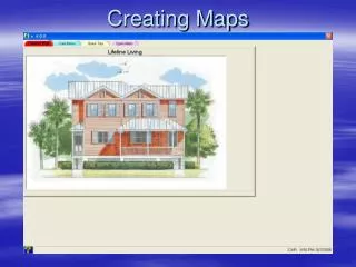
Creating Maps Using Coordinate Grids
Creating Maps Using Coordinate Grids. A Coordinate Grid Project. Timeline. Day 1: Introduction to Maps Start Classroom Map Day 2: Finish Classroom Map Share Maps Discuss difficulties of Mapping an Entire School Get in Teams and Brainstorm Day 3:

Creating Maps Using Coordinate Grids
E N D
Presentation Transcript
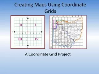
Creating Maps Using Coordinate Grids A Coordinate Grid Project
Timeline • Day 1: • Introduction to Maps • Start Classroom Map • Day 2: • Finish Classroom Map • Share Maps • Discuss difficulties of Mapping an Entire School • Get in Teams and Brainstorm • Day 3: • Explore the School with Your Team and Start Mapping. • Day 4: • (In Class) Constructing Map and Coordinate Grid • Day 5: • Finish Map and Coordinate Grid • Day 6: • Create Directory • Day 7: • Maps ready to share
What are maps? Discuss as a team: What do you already know about maps?
Political Maps • Shows boundaries and locations of cities.
Physical Map • Shows physical landscapes; rivers, lakes, mountains; etc.
Topographical Map • A physical map that also show elevations.
Climate Map • Shows climate (weather) zones for areas.
Economic Map • Type of map that shows the economic activity or natural resources in an area.
Road Map • Map that shows the major and/or minor highways and roads in the area.
What kind of Maps have you used? As a team, discuss your experience with various types of maps. When have you used a map? What are some different situations where you would need to use a map in real life? What are some different types of maps people encounter?
Why would you use a Map of the Mall? • Because it shows you where you are and how to get where you need.
Notice… • This map is color-coded and letter-coded. Why? • So you can locate the store you are looking for easier.
It’s kind of like longitude and latitude lines do on a globe… • It gives you coordinates!!
Latitude • A geographic coordinate that specifies the north-south position of a point on the Earth's surface.
Longitude • A geographic coordinate that specifies the east-west position of a point on the Earth's surface.
If you’re looking for the coordinates of a certain country on a globe, if you have the proper coordinates you can find it.
Could we create a coordinate map so we could locate classrooms; etc. easier?
Today, you are going to start with mapping out your classroom • Before creating a school map, start by creating a map of your classroom using a coordinate grid. • Use the instructions below to guide you in this process.
Step one: we must set a scale. • Scale is the ratio of a distance on the map to the corresponding distance on the ground
Scale • For this classroom I used a scale of 1 cm = 1.25 feet.
Step 2: Using paper and a ruler draw the classroom as you see it, keeping SCALE in mind.
Step #3: Draw a coordinate grid on top of your scaled drawing. Make sure the lines are evenly spaced and drawn neatly.
Step 4: Using a different color pen or pencil, divide the class into quadrants.
What are quadrants? • The two axes divide the coordinate grid into four areas called quadrants. The first quadrant, by convention, is the top right, and then they go around counter-clockwise.
Step 5: Create a Directory of AT LEAST 10 Locations along with Coordinates, and Quadrants
Your finished product should be a coordinate grid map (with quadrants) and a directory.
Extending your learning… • Now, can you work as a team to create a coordinate grid mapping of the school; complete with a scale and a directory that shows the coordinates and quadrant of at least 20 locations? • (Perhaps these maps could be used to help visitors to our school)
Final School Map • Your school map should be able to be used by an adult or another 5th grader. You should be able to hand them your map and directory of at least 20 places. After a brief explanation of how to read the map, they should be able to use the map to walk around the school and locate destinations that THEY would like to visit. Your map should be ready to use by visitors to our school.