
Nauset Inlet Water Line Changes: 1975-2009
Explore visual documentation of Nauset Inlet's water line at low tide from 1975 to 2009 through photographs from the Town of Orleans/Woods Hole Group archives. Witness the evolving landscape and inlet conditions over four decades.

Nauset Inlet Water Line Changes: 1975-2009
E N D
Presentation Transcript
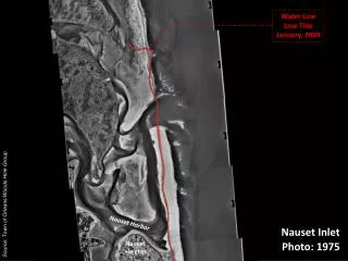
Water Line Low Tide January, 2009 Source: Town of Orleans/Woods Hole Group Nauset Harbor Nauset Inlet Nauset Heights Photo: 1975
Water Line Low Tide January, 2009 1975 Inlet Source: Town of Orleans/Woods Hole Group Nauset Harbor Nauset Inlet Nauset Heights Photo: 1981
Water Line Low Tide January, 2009 1981 Inlet 1975 Inlet Source: Town of Orleans/Woods Hole Group Nauset Harbor Nauset Inlet Nauset Heights Photo: 1990
1990 Inlet Water Line Low Tide January, 2009 1981 Inlet 1975 Inlet 1993 Break Source: Town of Orleans/Woods Hole Group Nauset Harbor Nauset Inlet Nauset Heights Photo: 1994
1990 Inlet Water Line Low Tide January, 2009 1981 Inlet 1994 Inlet 1975 Inlet 1993 Break Source: Town of Orleans/Woods Hole Group Nauset Harbor Nauset Inlet Nauset Heights Photo: 1996
1990 Inlet Water Line Low Tide January, 2009 1981 Inlet 1996 Inlet 1994 Inlet 1975 Inlet 1993 Break Source: Town of Orleans/Woods Hole Group Nauset Harbor Nauset Inlet Nauset Heights Photo: 2005
1990 Inlet Water Line Low Tide January, 2009 2009 Inlet 2005 Inlet 1981 Inlet 1996 Inlet 1994 Inlet 1975 Inlet 1993 Break Source: Town of Orleans/Woods Hole Group Nauset Harbor Nauset Inlet Nauset Heights Photo: 2008