A Sketch Interface for Mobile Robots
A Sketch Interface for Mobile Robots. Marjorie Skubic Craig Bailey George Chronis Computational Intelligence Research Lab University of Missouri-Columbia. Outline. Motivation and context Route maps The PDA sketch interface Experimental study and results Conclusions and future work.

A Sketch Interface for Mobile Robots
E N D
Presentation Transcript
A Sketch Interface for Mobile Robots Marjorie Skubic Craig Bailey George Chronis Computational Intelligence Research Lab University of Missouri-Columbia
Outline • Motivation and context • Route maps • The PDA sketch interface • Experimental study and results • Conclusions and future work
Spatial Reasoning with Guinness References Acknowledgements
Route Maps • Tversky’s work • Depictions vs. Descriptions • Extraction of route descriptions • 1 to 1 correlation • Michon and Denis • Landmarks and critical nodes
The Sketch Interface • Objects • Labels • Paths • Delete • Start • Move • Undo • Send
Objects • Closed Polygons • Any shape or size • Thresholds to determine gap closure • Feedback on recognition • Sound • Color
Labels • Default numbering for object labels • Tap on screen to edit • Can use Palm OS Graffiti recognition or a software keyboard
Paths • Limit of one • A minimum length required • Color Feedback
Path Direction • Default direction is the direction the path is drawn • User can specify the direction with a sketched “blob” to denote the start of the path Recognized by • Number of points • Average distance of all points • Proximity to path endpoint
Delete • An intuitive delete: cross out an object • Recognized by • Two consecutive strokes • Both lengths shorter than a path • The strokes cross • Color feedback • Search for closest object or path
Determining Crossed Marks • Use the slope equations of lines • Endpoints of strokes determine the line • A pair of decision parameters can be computed • If both parameters lie between 0 and 1, then the two strokes must have an intersection ua= (X4-X3)(Y1-Y3) - (Y4-Y3)(X4-X3) (Y4-Y3)(X2-X1) - (X4-X3)(Y2-Y1) ub= (X2-X1)(Y1-Y3) - (Y2-Y1)(X1-X3) (Y4-Y3)(X2-X1) - (X4-X3)(Y2-Y1) IF (0 < ua < 1) AND (0 < ub < 1) THEN the lines intersect (X1,Y1) (X3,Y3) (X2,Y2) (X4,Y4)
Menu Commands • Also accessible through graffiti • m Move • u Undo • c Clear • t Transmit • f Configure
User Evaluation • Tested how well the interface performed with real users • Pre-experimental questionnaire • Tasks • Sketch tasks • Re-sketch tasks • Task scores • Post-experimental questionnaire • Questionnaires contain Lickert style statements (Lickert, 1932) along with several open-ended questions
Statistical Analysis 2 groups, 2 scenes: • Compared by scene sketched • Compared by course level of participant • Means compared with the t test • Null Hypothesis: there are no differences when compared by sketched scene or course level
Participants • 26 students from CS courses • One participant scores was not used • Only 5 owned a PDA • Students of Scene B rated themselves significantly better at giving directions (p = 0.02) • No differences when compared by course level
Post-Experimental Survey:Landmark Scores1 = very difficult; 5 = very easy • Creating Landmarks • 4.6 ± 0.6 • Deleting Landmarks • 4.2 ± 0.9 • Usefulness of Deleting • 4.7 ± 0.6 • Usefulness of Labeling • 4.8 ± 0.6
Post-Experimental Survey: Path Scores1 = very difficult; 5 = very easy • Creating a path • 4.4 ± 1.0 • Deleting a path • 4.4 ± 1.0 • Usefulness of deleting • 4.7 ± 0.7 • Usefulness of the starting point • 4.2 ± 0.9
Post-Experimental Survey: Overall Scores • Usefulness of changing sketch • 4.8 ± 0.4 • Usefulness of deleting sketch • 4.2 ± 1.0 • How well sketch represents environment • 83.6 ± 7.4 • Overall ease of interface • 4.4 ± 0.6
Usability Results • Only two significant differences (p<=0.05) were found among the scores • Usefulness of deleting by scene (p=0.0) • Final sketch rating by scene (p=0.05) • In both cases, students in scene B rated higher • Same group that rated themselves better at giving directions • Differences were not found when compared by course level • The Null Hypothesis is accepted
Task Score Results • Collected sketches were scored • +1 for starting landmark • +1 for each correct turn • +1 for landmark at turn • +1 for each correct straight segment • + 1 for ending landmark • -1 for extra turns or straight segments • No significant differences found (p=0.12) • Sketch Task Score = 0.91 ± 0.11 • Re-sketchTask Score = 0.82 ± 0.26
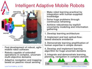
Conclusions • Created a new sketch based interface on a handheld computer • Intuitive and little reliance on traditional menus and icons • User evaluation finds the interface as easy to use as pencil and paper by 2:1
Future Work • Continue integration into the Guinness system • Recognition of more sketched symbols • Recognition of turning rate • Creation of 3D virtual environments with libraries of objects Email: SkubicM@missouri.edu Web: www.cecs.missouri.edu/~skubic funded by the Naval Research Lab
user commands and responses oldest short term map imageserver gesture speech GUI(EUT) query & label speech commands robot SR & map info user commands and responses spatial behaviors mapserver Cortex sensor info robot pose robot pose robot commands continuous localization pose SRserver trulla obstacle avoidance corrections PDA sketch directives & feedback sensor data robot cmds encoders vfh sensor data long term map short term map ARCHITECTURE
SRserver Behind the table User: How many objects do you see? Robot: I am sensing four objects. User: Object 2 is a table. User: Describe the scene. Robot: There are objects on my front right. The object number 4 is mostly in front of me. The table is behind me. User: Go behind the table.
between object 1 and object 2 using the midpoint between closest points using the midpoint between centroids using the CFMD
Understanding Sketched Route Maps PATH DESCRIPTION GENERATED FROM THE SKETCHED ROUTE MAP 1. When table is mostly on the right and door is mostly to the rear (and close) Then Move forward 2. When chair is in front or mostly in front Then Turn right 3. When table is mostly on the right and chair is to the left rear Then Move forward 4. When cabinet is mostly in front Then Turn left 5. When ATM is in front or mostly in front Then Move forward 6. When cabinet is mostly to the rear and tree is mostly on the left and ATM is mostly in front Then Stop
References [1] M. Skubic, P. Matsakis, G. Chronis and J. Keller, "Generating Multi-Level Linguistic Spatial Descriptions from Range Sensor Readings Using the Histogram of Forces", Autonomous Robots, Vol. 14, No. 1, Jan., 2003, pp. 51-69. [2] M. Skubic, D. Perzanowski, S. Blisard, A. Schultz, W. Adams, M. Bugajska and D. Brock “Spatial Language for Human-Robot Dialogs,” IEEE Transactions on SMC, Part C, to appear in thespecial issue on Human-Robot Interaction. [3] M. Skubic, S. Blisard, C. Bailey, J.A. Adams and P. Matsakis, "Qualitative Analysis of Sketched Route Maps: Translating a Sketch into Linguistic Descriptions," IEEE Transactions on SMC Part B, to appear. [4] G. Chronis and M. Skubic, “Sketch-Based Navigation for Mobile Robots,” In Proc. of the IEEE 2003 Intl. Conf. on Fuzzy Systems, May, 2003, St. Louis, MO. [5] G. Scott, J.M. Keller, M. Skubic and R.H. Luke III, “Face Recognition for Homeland Security: A Computational Intelligence Approach,” In Proc. of the IEEE 2003 Intl. Conf. on Fuzzy Systems, May, 2003, St. Louis, MO.
Guinness and Gang From left to right George Chronis, Grant Scott, Dr. Marge Skubic, Matt Williams, Craig Bailey, Bob Luke, Charlie Huggard and Sam Blisard Missing: Dr. Jim Keller
Sketch-Based Navigation The robot traversing the sketched route The sketched route map
Sketch-Based Navigation The robot traversing the sketched route The digitized sketched route map
Acknowledgements This work has been supported by ONR and the U.S. Naval Research Lab. Natural language understanding is accomplished using a system developed by NRL, called Nautilus [Wauchope, 2000]. We also want to acknowledge the help of Dr. Pascal Matsakis.