Download
1 / 48
480 likes | 657 Views
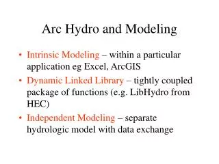
Arc Hydro and Modeling. Intrinsic Modeling – within a particular application eg Excel, ArcGIS Dynamic Linked Library – tightly coupled package of functions (e.g. LibHydro from HEC) Independent Modeling – separate hydrologic model with data exchange . Streams Drainage Areas Hydrography

E N D
Arc Hydro and Modeling • Intrinsic Modeling – within a particular application eg Excel, ArcGIS • Dynamic Linked Library – tightly coupled package of functions (e.g. LibHydro from HEC) • Independent Modeling – separate hydrologic model with data exchange
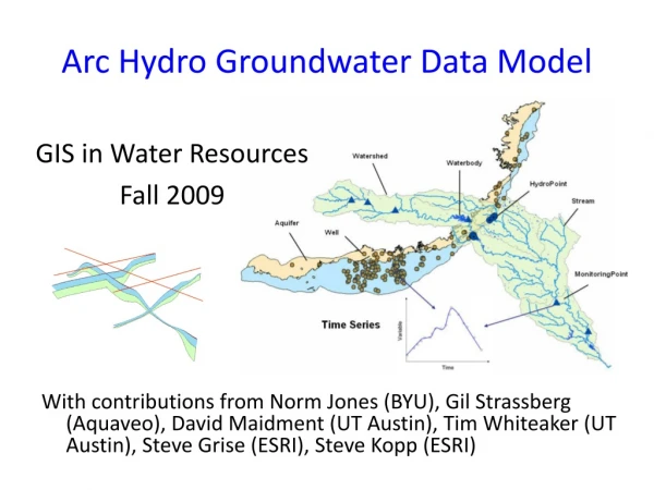
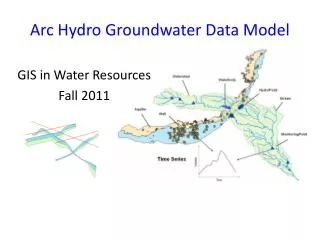
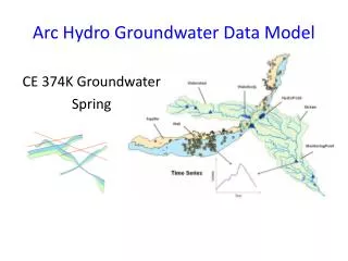
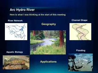
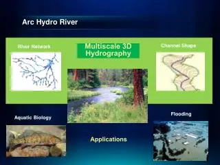
Streams Drainage Areas Hydrography Channels Terrain Surfaces Rainfall Response Digital Orthophotos Thematic Layers supporting the Arc Hydro data model (from Michael Zeiler “Modeling Our World” Volume 2)
Data Model Based on Behavior Follow a drop of water from where it falls on the land, to the stream, and all the way to the ocean.
Integrating Data Inventory using a Behavioral Model Relationships between objects linked by tracing path of water movement
Intrinsic Hydrologic Modeling • Dr Tarboton • DEM-based hydrologic modeling • USGS • Stream Stats • Mean annual flows and pollutant loads Streamstats http://ststdmamrl.er.usgs.gov/streamstats/expert.htm
Dynamic Linked Library Can have Fortran subroutines in a DLL Muskingum flow routing
Independent Hydrologic Model VB progam reads and writes text files
Analysis, Modeling, Decision Making Arc Hydro Geodatabase Interfaces to Arc Hydro Data and Models Excel ArcGIS Relational Database (Access) Visual Basic
Water Resources Data Model ArcGIS Hydro Data Model ArcGIS GeoDatabase ArcGIS Development at DHI • Extend the ArcGIS Hydro Data Model
DHI TimeSeries Package • TimeSeries Package Architecture
Three basic water problems • Too little water (Drought and water supply) • Too much water (Flooding) • Its dirty (Water Quality) Also have significant GIS effort on environmental issues related to water such as habitat assessment
1996 Texas Drought • George W. Bush, (then Governor of Texas) asked: “Tell me how much water we have, how much water we’re using and how much water we need” • State water officials did not have adequate answers
Texas Water Planning • 1997 Texas Legislature passed Senate Bill 1 which provided for • State-wide geospatial data development (topography, hydrography, land use, soils and orthophotos) • Water planning in 14 regions rather than state-wide • Assessment of water availability for all water permits
Hydrologic Cataloging Units (HUCS) Hydrologic Unit Code = 12100203 Guadalupe Basin (4 HUC’s) • 2015 HUC’s cover continental US • average area ~ 1 county
Stream Gauge (14) Water Diversion (440) Water Availability in the Guadalupe Basin Estimate water availability at each legally permitted water diversion point based on “naturalized” flow at stream gages and the effects of other permitted diversions
Digital Elevation Model San Marcos basin National Elevation Dataset 30m x 30m cells 11,000,000 cells to cover San Marcos basin 70,000,000 cells to cover Guadalupe basin
Drainage Area Delineated from the Digital Elevation Model Arc Hydro attribute DrainArea
Ad Af Qd = Qf Estimating Naturalized Flow at Diversion Points Naturalized flow record at stream gage (50 years of monthly flows) Qf Af Qd Estimated flow record at diversion point Ad
Length Downstream Flow distance (D to F) = Length Downstream (D) – Length Downstream (F) Length Downstream (F) F D D Seepage losses F Length Downstream (D) Arc Hydro attribute LengthDown
Water Rights Analysis Package (WRAP) 50 year series of naturalized monthly flows at stream gages Hydrologic Modeling GIS data for each diversion point Water Availability Modeling Letter to each water permit owner specifying % of permitted flow available during a drought Completed for ~ 10,000 water permit holders, 1998-2002
Water Availability Assessment (completed for ~ 10,000 permit holders, 1998-2001) Texas Natural Resources Conservation Commission Hydrologic modeling by engineering consultants Letter to each water permit owner specifying % of permitted flow available during a drought Geospatial data development by Center for Research in Water Resources, Univ. of Texas
Flood Hydrology and Hydraulics ArcView Input Data DEM ArcView Flood plain maps HEC-GeoHMS Hec-GeoRAS HEC-RAS Water surface profiles HEC-HMS Flood discharge
Status of the Software • HEC-GeoHMS ver 1.0 available from HEC for ArcView version 3 http://www.hec.usace.army.mil/software/software_distrib/geo-hms4arcview/geohmsprogram.html • Arc Hydro terrain and watershed functions replace some but not all of HEC-GeoHMS • HEC-GeoRAS ver 1.0 http://www.hec.usace.army.mil/software/software_distrib/geo-ras4arcview/georasprogram.html • ESRI has developed a beta-version of GeoRAS for ArcGIS
Austin Digital Elevation Model Waller Creek
CRWR-PrePro (a precursor of HEC-GeoHMS) Digital Elevation Model Stream Map ArcView-based preprocessor for HEC-Hydrologic Modeling System (HEC-HMS) Control point locations Soil and Land Use Maps HMS Basin File
Selected Watersheds and Streams Mansfield Dam Colorado River
HMS Schematic Prepared with CRWR-PrePro Mansfield Dam Colorado River
HMS Results Watershed 155 Junction 44
Flood Hydrology and Hydraulics ArcView Input Data DEM ArcView Flood plain maps HEC-GeoHMS Hec-GeoRAS HEC-RAS Water surface profiles HEC-HMS Flood discharge
Colorado River Network 1:100,000 scale Developed from National Hydrography Dataset
City of Austin Stream Network Developed from 1”=100’ Capco Areal photogrammetry 1:1200 scale
Stream Definition: Waller Creek Austin Watersheds with Streamsderived from Aerial Photographs Streamlines generated by the aerial photographs are not always continuous.
Information for Correcting Stream Network • DEM • Contours • Storm sewers • Orthophotos
Resulting Corrected Stream • Subsequent steps: • Verification of corrected streams by flood hydrologists. • Running “tracer” program to connect arcs. • Burning of streams into DEM.
Flood Hydrology and Hydraulics ArcView Input Data DEM ArcView Flood plain maps HEC-GeoHMS Hec-GeoRAS HEC-RAS Water surface profiles HEC-HMS Flood discharge
HEC-RAS: Background • River Analysis System model of the U.S. Army Corps of Engineers • Input = cross-section geometry and flow rates • Output = flood water elevations Cross-Section Schematic
Waller Creek Watersheds Network Channel
HEC-RAS: Cross-Section Description • Points describe channel and floodway geometry • Bank station locations • Water surface elevations and floodplain boundaries
HEC-RAS: Output Graphical Text File