Download

1 / 80
840 likes | 1.12k Views
Arc Hydro: GIS for Water Resources. David R. Maidment, University of Texas at Austin. Why should the Corps of Engineers be interested in Arc Hydro? Watershed planning Reservoir operations Flood damage reduction Ecosystem restoration. Hydrologic Modeling. Hydrologic Information System.

E N D
Arc Hydro: GIS for Water Resources David R. Maidment, University of Texas at Austin • Why should the Corps of Engineers be interested in Arc Hydro? • Watershed planning • Reservoir operations • Flood damage reduction • Ecosystem restoration
Hydrologic Modeling Hydrologic Information System Arc Hydro Geodatabase
1996 Texas Drought • George W. Bush, (then Governor of Texas) asked: “Tell me how much water we have, how much water we’re using and how much water we need” • State water officials did not have adequate answers
Texas Water Planning • 1997 Texas Legislature passed Senate Bill 1 which provided for • State-wide geospatial data development (topography, hydrography, land use, soils and orthophotos) • Water planning in 14 regions rather than state-wide • Assessment of water availability for all water permits
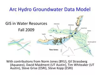
Hydrologic Cataloging Units (HUCS) Hydrologic Unit Code = 12100203 Guadalupe Basin (4 HUC’s) • 2015 HUC’s cover continental US • average area ~ 1 county
Stream Gauge (14) Water Diversion (440) Water Availability in the Guadalupe Basin Estimate water availability at each legally permitted water diversion point based on “naturalized” flow at stream gages and the effects of other permitted diversions
Digital Elevation Model San Marcos basin National Elevation Dataset 30m x 30m cells 11,000,000 cells to cover San Marcos basin 70,000,000 cells to cover Guadalupe basin
Drainage Area Delineated from the Digital Elevation Model Arc Hydro attribute DrainArea
Ad Af Qd = Qf Estimating Naturalized Flow at Diversion Points Naturalized flow record at stream gage (50 years of monthly flows) Qf Af Qd Estimated flow record at diversion point Ad
Length Downstream Flow distance (D to F) = Length Downstream (D) – Length Downstream (F) Length Downstream (F) F D D Seepage losses F Length Downstream (D) Arc Hydro attribute LengthDown
Water Rights Analysis Package (WRAP) 50 year series of naturalized monthly flows at stream gages Hydrologic Modeling GIS data for each diversion point Water Availability Modeling Letter to each water permit owner specifying % of permitted flow available during a drought Completed for ~ 10,000 water permit holders, 1998-2002
Water Availability Assessment (completed for ~ 10,000 permit holders, 1998-2001) Texas Natural Resources Conservation Commission Hydrologic modeling by engineering consultants Letter to each water permit owner specifying % of permitted flow available during a drought Geospatial data development by Center for Research in Water Resources, Univ. of Texas
Arc Hydro data model design completed and published on web (http://www.crwr.utexas.edu/giswr) Arc Hydro book in production at ESRI Press Arc Hydro toolset v. 1.0 in beta testing Accomplishments
CD-ROM at back of book Arc Hydro UML diagrams, Repository, Example Geodatabases, Toolset, Tutorials
Arc Hydro Toolset Ver 1.0 Provides tools for processing raster and vector data and populating the attributes of the Arc Hydro data model
Bringing together these two communities by using a common geospatial data model http://www.crwr.utexas.edu/giswr CRWR GIS CRWR GIS in Water Resources Consortium Water Resources
Drainage System Hydro Network Flow Time Time Series Hydro Features Channel System ArcGIS Hydro Data Model
ArcGIS Hydro Data Model Hydrology Hydrography
Data Model Based on Inventory Streams Drainage Areas Hydrography Channels Terrain Surfaces Rainfall Response Digital Orthophotos
Data Model Based on Behavior Follow a drop of water from where it falls on the land, to the stream, and all the way to the ocean.
Integrating Data Inventory using a Behavioral Model Relationships between objects linked by tracing path of water movement
Arc Hydro Framework Input Data Watersheds Waterbody Streams HydroPoints
HydroNetwork through Canyon Lake Flowlines through water body Generic Junction (for topological connection of edges)
Scales of representation of Drainage Systems Basins – drainage areas for water resources management Watersheds – subdivision of Basin for a particular hydrologic purpose Catchments – subdivision of Basin into elementary drainage areas by physical rules Digital Elevation Model – land surface terrain grid cells
Watersheds of the Guadalupe Basin NWS forecast Watersheds (flooding) Guadalupe HydroNetwork EPA TMDL Segments (water quality) TNRCC water availability points (water supply)
EDNA – Elevation Derivatives for National Application http://edcw2ks22.cr.usgs.gov/website/edna/viewer.htm
Regional Analysis HydroNetwork to provide connectivity of flow through large regions Digital elevation model for terrain analysis within basins
Michael Schultz NWS River Forecast Center Fort Worth, Texas 1998 Guadalupe Flood
Cross-Sections developed using HEC-GeoRAS and National Elevation Dataset
Hydrologic simulation Using NWS Fldwav model
Guadalupe Network Study area only 1.4 km!
Study Area (Guadalupe river near Seguin, TX) 1/2 meter Digital Ortho Photography
Accoustic Doppler Current Profiler Provides full profiles of water velocity and direction in the ocean, rivers, and lakes. Also used for discharge, scour and river bed topography.
Depth Sounder (Echo Sounder) The electronic depth sounder operates in a similar way to radar It sends out an electronic pulse which echoes back from the bed. The echo is timed electronically and transposed into a reading of the depth of water.
Differential GPS: Bank to Boat GPS gives the location of each point collected in terms of latitude and longitude. Two locations for differential GPS.
Channel Data Each point has (x,y,z)
Interpolation Points are interpolated in ArcMap to produce a continuous surface.
FishNet (2D) FishNet is generated in ArcMap using FishNet tool in ArcGIS.
Centerline Define the centerline such that it joins the center of flow (area) at each cross section.