Download
1 / 17
170 likes | 194 Views
Developing a Cooperative Wetland Condition Assessment for the Nanticoke Watershed. The Research Stage David Bleil MD Department of Natural Resources. Project Goals. Develop Skills in Wetland Condition Surveying at the Watershed Level.

E N D
Developing a Cooperative Wetland Condition Assessment for the Nanticoke Watershed The Research Stage David Bleil MD Department of Natural Resources
Project Goals • Develop Skills in Wetland Condition Surveying at the Watershed Level. • Develop a consistent data set of known quality and maximum usefulness. • Add Wetland Condition to Department’s landscape focus. • Meet CWA Sect. 305 (b) reporting requirements for unmodified wetlands
Integration of Field and GIS Expertise • Departmental Reorganization Integration of field evaluation staff and GIS landscape analysis and remote sensing staff. • Departmental focus on watershed- based integrated resource management
Data Sharing agreements –MSGICC requirements Data acquisition for Level 1 assessments Prior HGM reclassification of Nanticoke wetlands by NWI. Cooperative scheduling of field work & training Cooperative protocol development for level 2 & 3 assessment Developing A Cooperative Interstate Venture in the Nanticoke
Working with Volunteers • Part of the initial plan • Requires resources to recruit, train, organize & equip -- no free lunch! • Can supplement staff expertise • Builds public support • Liability issues are not trivial • State vehicle policy • Health & safety • Volunteers can easily work across political boundaries
DNR Integrated resource assessment – quality of natural systems Watershed Restoration Action Strategies Green Infrastructure assessment MDE Regulatory focus Site specific applications– impacts and restorations Water quality monitoring responsibilities Maximizing Data Usefulness across state agencies
Integration of spatially random sample design for wetland condition surveys with the MD Biological Stream Survey. Integration with the stream condition surveys of WRAS development Integration of tiered assessment approach and level 3 vegetation sampling with the Green Infrastructure ground truth assessment. Integration of wetland condition field data with GIS analysis. Optimizing Data Usefulness Within State Agencies
Lessons learned To be applied
Water in the wetlands may be visible and measurable onlyduring portions of a year Index of condition will be based on vegetation. Vegetation is impacted by hydrology. Vegetation impacts hydrology
Now you see it… Now you see
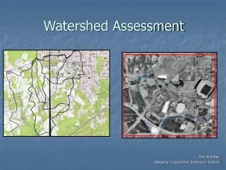
Level 1 – GIS Assessment • Nanticoke study benefited from recent NWI update – data not available statewide yet. • Limits of accuracy of level 1 set by spatial data quality and currency. • Field verification is required even for “non-impacted” wetlands • Wetlands are embedded in a dynamic landscape and react to their surroundings.
Key: Red Outline= NWI boundaries Red dots = GPS points Black line = SHA road
Future needs • Improved spatial data: resolution, positional accuracy, temporal accuracy • Extended HGM classification of wetlands maps statewide • Additional botanical expertise for field staff