Download
1 / 12
120 likes | 132 Views
This research aims to develop a surface reflectance standard product for the Land Data Continuous Mapper (LDCM) and validate it using AERONET data. It includes algorithms for cloud masking and shadow screening, vicarious calibration, and collaboration with international earth observation programs.

E N D
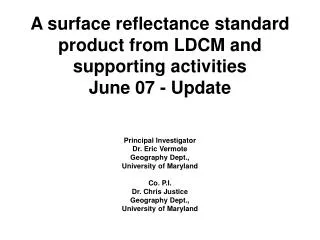
A surface reflectance standard product from LDCM and supporting activities Principal Investigator Dr. Eric Vermote Geography Dept., University of Maryland Co. P.I. Dr. Chris Justice Geography Dept., University of Maryland
Rationale for the research activities • A Surface Reflectance standard product developed for MODIS provides the basis for a number of higher order land products for global change and applications research • It is possible to develop an operational robust, globally applicable and fully automated code for integration into the LDCM processing chain and the code made openly available for others to use (e.g. LDCM ground stations). • The approach has already been testing by the LEDAPS project.
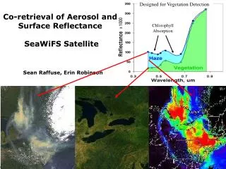
Atmospheric effect has a strong impact on remotely sensed data MODIS Granule over South Africa (Sept,13,2001, 8:45 to 8:50 GMT) Corresponding aerosol optical thickness at 670nm (0 black, 1.0 and above red) linear rainbow scale. Clouds are in magenta, water bodies are outlined in white. RGB surface reflectance (corrected for aerosol) RGB no correction for aerosol effect
BOREAS ETM+ scene Scene: p033r021 Date: 09/17/2001 Top-of-atmosphere TOA Surface Reflectance
Approach for the surface reflectance product • Atmospheric correction consistent with the MODIS and NPP approach, ensuring consistent reflectance data across resolutions based on rigorous radiative transfer http://6s.ltdri.org http://rtcodes.ltdri.org/
Approach for the surface reflectance product • Validation and uncertainties estimates. Theoretical error budget, comprehensive evaluation.
Approach for the surface reflectance product http://mod09val.ltdri.org/cgi-bin/mod09_c005_public_allsites_onecollection.cgi about 5000 cases analyzed
Preliminary evaluation of the LEDAPS ETM+ surface reflectance product • DATE.PATH/ROW AOT TIMEDIFF AERONET SITE • a2000122.w2p041r036 0.0932345 15 Rogers_Dry_Lake-001221821.mie • a2000122.w2p041r037 0.162749 15 UCLA-001221823.mie • a2000170.w2p009r029 0.0449007 60 Kejimkujik-001701451.mie • a2000191.w2p028r035 0.0858729 30 Cart_Site-001911659.mie • a2000247.w2p036r038 0.0365191 205 Tucson-002471753.mie • a2000261.w2p022r039 0.0722956 14 Stennis-002611628.mie • a2000267.w2p048r026 0.0727889 14 Saturn_Island-002671842.mie • a2001155.w2p034r036 0.105914 29 Sevilleta-011551737.mie • a2001216.w2p029r030 0.133025 14 Sioux_Falls-012161656.mie • a2001217.w2p036r025 0.0797376 188 Bratts_Lake-012171728.mie • a2001218.w2p043r028 0.0735507 254 Rimrock-012181817.mie • a2001267.w2p034r032 0.0717833 14 BSRN_BAO_Boulder-012671730.mie • a2001278.w2p015r033 0.147011 15 GSFC-012781537.mie
Preliminary evaluation of the LEDAPS ETM+ surface reflectance product Band 3 Band 4
Preliminary evaluation of the LEDAPS ETM+ surface reflectance product Filtered for water pixels (using a simple threshold in band 3 and 4 ) but the cloud mask has not been applied
R and D Areas Extend validation/evaluation exercise and develop fully automated procedures Refine the Cloud/Cloud shadow algorithm Establish absolute radiometric calibration to the 2% level Operational implementation of the adjacency effect correction Coastal water retrievals Aerosol type inversion
Summary The objectives of this proposal are summarized in the following seven tasks: • to provide an algorithm and code for a Surface Reflectance Standard Product for integration into the LDCM processing system. • prior to LDCM launch, to test the proposed approach on the Mid-decadal Global Land Survey (MDGLS) Phase 3. • to validate the resulting LDCM product, using data from AERONET • to provide a cloud masking and cloud shadow screening algorithm for LDCM • to undertake vicarious calibration of the LDCM instrument • to advise on and contribute to the LDCM program outreach and explore the potential synergy with other high resolution international earth observation programs (e.g. through the GOFC/GOLD and IGOL programs). • to be an active contributor to the LDCM Team, participating in telecons, science team meetings and working groups as appropriate.