Download
1 / 18
200 likes | 344 Views
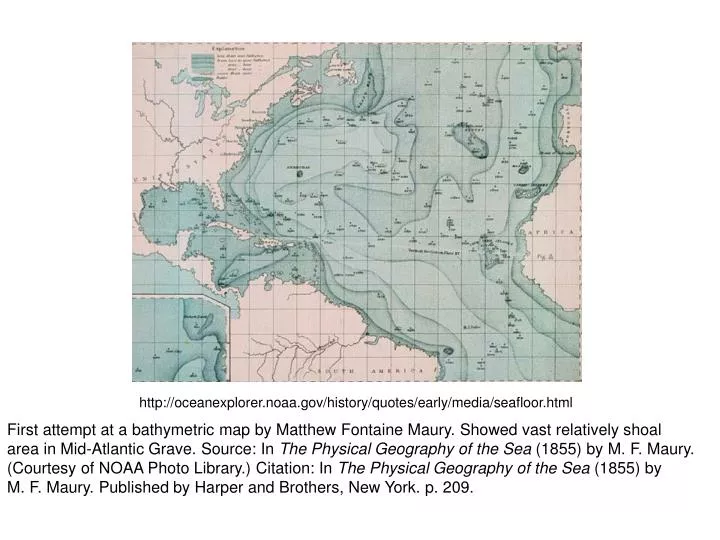
http://oceanexplorer.noaa.gov/history/quotes/early/media/seafloor.html. First attempt at a bathymetric map by Matthew Fontaine Maury. Showed vast relatively shoal area in Mid-Atlantic Grave. Source: In The Physical Geography of the Sea (1855) by M. F. Maury.

E N D
http://oceanexplorer.noaa.gov/history/quotes/early/media/seafloor.htmlhttp://oceanexplorer.noaa.gov/history/quotes/early/media/seafloor.html First attempt at a bathymetric map by Matthew Fontaine Maury. Showed vast relatively shoal area in Mid-Atlantic Grave. Source: In The Physical Geography of the Sea (1855) by M. F. Maury. (Courtesy of NOAA Photo Library.) Citation: In The Physical Geography of the Sea (1855) by M. F. Maury. Published by Harper and Brothers, New York. p. 209.
http://hercules.kgs.ku.edu/hexacoral/expedition/challenger_1872-1876/challenger.htmlhttp://hercules.kgs.ku.edu/hexacoral/expedition/challenger_1872-1876/challenger.html
http://www.marconi-marine.com/products/jrc/images/jfv-250.jpghttp://www.marconi-marine.com/products/jrc/images/jfv-250.jpg http://www.devilgas.com/old/echo_sounder.gif
http://www.mapquest.co.uk/cgi-bin/ia_find?link=school/worldatlas_print&atlas=oceans&uid=u9g2tdn6t9l5l7ja:255zbn94tshttp://www.mapquest.co.uk/cgi-bin/ia_find?link=school/worldatlas_print&atlas=oceans&uid=u9g2tdn6t9l5l7ja:255zbn94ts http://www.scotese.com/modern.htm
http://www.ngdc.noaa.gov/mgg/bathymetry/arctic/currentmap.htmlhttp://www.ngdc.noaa.gov/mgg/bathymetry/arctic/currentmap.html http://walrus.wr.usgs.gov/infobank/gazette/html/regions/ts.html http://www.worldlanguage.com/CountryMaps/270.gif http://www.jgk.org/map/world-ocean-large.html
http://www.thomasbdunklin.com/gallery/OE_figures/SeaLevel_Curve_2http://www.thomasbdunklin.com/gallery/OE_figures/SeaLevel_Curve_2
http://en.wikipedia.org/wiki/Image:Caribbean-map.gif http://en.wikipedia.org/wiki/Image:Atlantic-trench.JPG
http://www.seismo.unr.edu/ftp/pub/louie/class/plate/images_predict.HTMLhttp://www.seismo.unr.edu/ftp/pub/louie/class/plate/images_predict.HTML