Download
1 / 67
670 likes | 802 Views
The Polar Communications and Weather Mission (PCW) A new Mandate for Environment Canada. G. Szejwach and L. Garand March 25, 2011. Contents. PCW Mission Objectives Status and Major Milestones EC’s Mandate within the PCW Mission Overall Ground Segment Concept

E N D
The Polar Communications and Weather Mission (PCW) A new Mandate for Environment Canada G. Szejwach and L. Garand March 25, 2011
Contents PCW Mission Objectives Status and Major Milestones EC’s Mandate within the PCW Mission Overall Ground Segment Concept Functions associated with the Application Ground Segment Facilities Baseline List of Products Data Volumes Creating the new PWC Data Processing Center Manpower Resources Estimates Suggestions and Recommendations Conclusion
PCW Mission Objectives 24/7 communications in Canadian Arctic in support of: - DND operations - air and marine traffic - communities 24/7 high spatial resolution meteorologicaldata above 50º N in support of: Numerical Weather Prediction (short to medium range) Environmental monitoring, emergency response Climate monitoring Space and Weather Monitoring
Status and Major Milestones Approved and Funded Phase 0 completed: September 2008 Phase A contract awarded: July 2009 Phase A Major Milestones Technology Readiness Assessment Review: October 2009 Critical Technologies Development procurement: February 2009 Mission Requirements Review: February 25, 2010 Preliminary System Requirements Review: June 2010 Phase A closure: March 31, 2011 Approval and Funding Still Required Phase B contract award: late 2011, start mid 2012 PPP approach likely Launch of Satellite 1: Q1 2017 Launch of Satellite 2: Q2 2017 PCW is top priority program at CSA
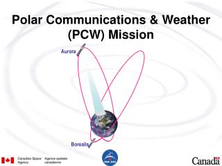
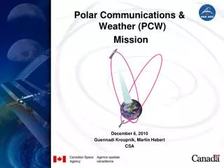
Baseline12-h orbit concept Apogee: 39,500 km Perigee: 600 km 2 sats in one plane leading to 4 apogees separated by 90 deg Ref: Trishchenko and Garand, Jtech, 2011
Revised orbital concept: 16-h orbit • Apogee: ~43,500 km • Perigee: ~8,100 km • Main advantage: • Much less subject • to damage from • protons than 12-h • orbit Suggested apogees: 950W; 250E, 1450E Three APogee (TAP) orbit
Zonal mean coverage: 12-hr vs 16-hr orbit Better coverage with higher orbit inclination, but may Require more fuel for maintenance From: Trischenko et al, 2011 (JTech)
Science Team activities Orbital analysis Radiance simulations (RRTOV, CRTM) Import U. Wisconsin AMV software OSSE on PCW AMV impact Support proposals of additional atmospheric payloads (UV-VIS-NIR, FTS) Definition of future PCW Data Processing Center
EC’s Mandate within the PCW mission Primary user of the meteorological mission Responsible for: Operational processing Product generation Archiving & retrieval Data distribution/dissemination: national & international PCW has a mandate similar to that of NOAA, Eumetsat or GMA
Overall Ground Segment Concept • Initial industrial concept Constellation in High Eccentricity Orbit Data pre-processing (Level 0 to Level 1c) Meteorological Products Generation (Level 1 to Level 2)
Ground Station PCW Meteorological Data Flow Raw data Archive Products Raw data Archive Users Met Primary Data Processing Facility (PDPF) Products Archival & Retrieval Facility (PARF) Processed images WWW & FTP Other Users Processed images Meteorological products Subset of Products Met. Applications Processing Facility (MAPF) Products Acquisition & Distribution Facility (PADF) Foreign National Weather Services Near-real time Products Meteorological products
Ground Station PCW Meteorological Data Flow PCW Application Data Center Raw data Archive Products Raw data Archive Users Met Primary Data Processing Facility (PDPF) Products Archival & Retrieval Facility (PARF) Processed images WWW & FTP Other Users Processed images Meteorological products Subset of Products Met. Applications Processing Facility (MAPF) Products Acquisition & Distribution Facility (PADF) Foreign National Weather Services Near-real time Products Meteorological products
Functions associated with Data Pre-processingPrimary Data Processing Facility (PDPF) • Nominally developed by CSA, operated by EC • Generate geometrically rectified and radiometrically corrected images from the level 0 (raw) data which enter the PDPF from the Primary Ground Station. This involves the following actions: • Data acceptance and Preparation • Level 0 Data pre-processing • Navigation extraction • Level 0 data resampling • Radiometric calibration processing • Geometric Calibration processing • Radiometric quality assessment • Geometric quality assessment
PDPF Functional Architecture and Interfaces Met. Primary Data Processing Facility (PDPF) Primary Ground Station (PGS) Level 0 Checking Pre-Processing 0 Other Products Generators Level 0 to 1c Processing Navigation Extraction Level 0 data resampling Geometric Calibration Radiometric Calibration Space Weather and Other L1 Meteorological Data Radiometric and Geometric Quality Assessment Calibration Meteorological ApplicationsProcessing Facility (MAPF) Products Archive and Retrieval Facility (PARF) Image Quality 0 1c Transfer Image Data 1b 1c Products Acquisition and Distribution Facility (PADF) 1b 1c
Functions associated with Product Generation Meteorological Application Product Facility (MAPF) • Meteorological Product generation is performed within the Meteorological Application Product Facility (MAPF) from Level 1 image data supplied by the Primary Data Processing Facility (PDPF). • After quality control, encoded products are delivered to users and to the Product Archive and Retrieval Facility (PARF) for online and offline retrieval. MAPF functions include: • Reception of processed image data and associated auxiliary data from the Meteorological Primary Data Processing Facility (PDPF). These include all Level 1 data • Data checking and acceptance
Functions associated with Product Generation Meteorological Application Product Facility (MAPF) • MAPF functions (cont.) • Meteorological product (and other as required) generation (Level 2 and above) • Calibration monitoring • Product verification • Analysis and reporting • Visualisation and analysis • Monitoring and control • Distribution of products to the Product Acquisition and Dissemination Facility (PADF)
MAPF Functional Architecture and Interfaces Met. Primary Data Processing Facility (PDPF) 1b 1c Meteorological Applications Processing Facility (MAPF) Data Checking Acceptance Data Integrity External Data Product Generation Science Team (R&D) Image Quality Algorithms Calibration Calibration Monitoring Cal/Val Product Verification Validation & Reporting Product Quality U S E R S Products Acquisition and Distribution Facility (PADF) Product Availability Products Archive and Retrieval Facility (PARF) 1c 2,3 Products Transfer 2,3 Forecast Analysis EC Forecast Office
Functions associated with Product Distribution Product Acquisition and Distribution Facility (PADF) • The PADF performs the acquisition and the distribution of PCW image data and meteorological products generated by EC or by other entities (TBD). • The data streams coming into the PADF will include: • Processed Image data from the Meteorological Primary Data Processing Facility (PDPF) • Meteorological products from the MAPF • Archive Products from the PARF and/or other entities (TBD) • Service messages (e.g. service or test messages) • Others (for future extension)
PADF Functional Architecture and Interfaces Users Archive Data Users Registered Users Operational (Weather) Services WWW Products Acquisition and Distribution Facility(PADF) Data Hub Near Real Time Dissemination (Land lines or Telecast) PCW Web Site User Support Public at Large Products Subset of L 1c,2,3 Products Subset of L1c, 2,3 Products Scheduling Near Real Time Products 1c 2,3 1b,c 2,3 Meteorological ApplicationsProcessing Facility (MAPF) Products Archive and Retrieval Facility (PARF)
Functions associated with Archiving & Retrieval Products Archive & Retrieval Facility(PARF) • The Users Requirement Document (URD) [Ref.1] defines the archiving requirements as follows: • PCW meteorological data must be archived. Details are to be developed, but the following are current requirements: Level 0, 1c and 2 data is required to be archived indefinitely, along with the accompanying metadata including satellite information. Level 1b data must be stored for 5 years after acquisition. • The data archiving system should be able to generate any Level 1b data files on demand, starting from Level 0 data and corresponding metadata.
Functions associated with Archiving & Retrieval Products Archive & Retrieval Facility(PARF) • The Product Archive and Retrieval Facility (PARF) should provide the following functions: • Acquisition & archiving of images data up to Level 1c • Acquisition and archiving of Level 2 and above products elaborated by the MAPF • Acquisition and archiving of Level 2 and above products elaborated by other entities (TBD) • Generation and maintenance of catalogues covering the archived data sets • Provision of on-line catalogue query and product retrieval
Functions associated with Archiving & Retrieval Products Archive & Retrieval Facility(PARF) • Provision to the end users of a comprehensive set of services allowing access to the archived data sets and related information • Provision of an information service giving access to PCW or PARF specific operations-related data • Provision of an interface to the other facilities in the Ground Segment for generating/updating information of relevance to the end users covering operational aspects • Distribution of products to the Product Acquisition and Dissemination Facility (PADF) (TBC)
PARF Functional Architecture and Interfaces Primary Data Processing Facility (PDPF) Meteorological ApplicationsProcessing Facility (MAPF) 0,1b,c 2,3 Products Archive & Retrieval Facility (PARF) Acquisition Archive Repository Formatting & Delivery Products Acquisition and Distribution Facility (PADF) User Services Catalogue PARF USERS
PARF Functional Architecture and InterfacesOther Government Agencies (mixed option) Other Products Providers Primary Data Processing Facility (PDPF) Meteorological ApplicationsProcessing Facility (MAPF) Products 0,1b,c 2,3 Local Repository Products Archive & Retrieval Facility (PARF) Formatting & Delivery 2,3 Acquisition Archive Repository Formatting & Delivery Catalogue Products Acquisition and Distribution Facility (PADF) User Services User Services Catalogue PARF USERS Direct Users
Calibration, Validation, and Reprocessing • CEOS WORKING GROUP on Cal/Val: • Calibration: The process of quantitatively defining the system responses to known, controlled signal inputs. • Validation: The process of assessing, by independent means, the quality of the data products derived from the system outputs. • GSICS (Global Space-based Inter-Calibration System) • The PCW application ground segment should be designed to adhere to GSICS conventions on Cal/Val • Small impact on archive and reprocessing facilities
Functions associated with Calibration and Validation • Within PDPF: • Perform routine modification of calibration coefficients (using on-board measurements) • Monitor and update the calibration values used to generate Level 1c images • Forward the calibration constants values to the Meteorological Product Application Facility (MAPF)
Functions associated with Calibration and Validation • Within MAPF: • Assess the quality of the calibration coefficients using meteorological data • Propose recommendations to the PDPF in preparation for next image • Perform routine validation through inter-comparison as part of GSICS activities • Analyze historical calibration data to find out if a problem exists • Perform reprocessing of past products, as required, using the Reprocessing Facility
PCW Application Ground Segment Functional Architecture: Reprocessing Facility Products Archive and Retrieval Facility (PARF) Meteorological Applications Processing Facility (MAPF) Levels 2 & above Processing Levels 2 & above Products Repository 2,3 GSICS Products & Calibration Repository Level 0 Repository Level 1 Repository L0 L1 2,3 Reprocessing Facility (RF) Level 0 to 1 Processing Levels 2 & above Processing Off-Line USERS L1
Functions associated with Mission Monitoring, Reporting, & User Support • Mission monitoring and reporting (within MAPF): • Product quality assessment • Provision of statistics on product delivery, timeliness, availability • Preparation of reports for users and management • User support (within PARF and PADF): • Answer to queries • Interface with users for PARF and other products • Elaboration and distribution of information material (written form or web-based)
Baseline List of PCW Products (1) Baseline List of Products from PCW Imager (as of 16 September 2010) Imagery and Priority 1 Products Note: Near real time products are derived from Level 1c
Baseline List of PCW Products (2) Baseline List of Products from PCW Imager (as of 16 September 2010) Priority 2 - Level 2/3 generated by EC
Baseline List of PCW Products (3) Baseline List of Products from PCW Imager (as of 16 September 2010) Priority 2 - Level 3 climate essential variables products and archive Products can be elaborated by EC or Other Government Department
Near Real Time Data Volumes • Level 0 data received by the Primary Data Processing Facility (PDPF) • Level 1 data received, and Level 2,3 data transmitted, by the Meteorological Application Processing Facility (MAPF) • Level 1,2,3 data distributed by the Product Acquisition and Distribution Facility (PADF)
Other Products Data Volumes • Archive and Retrieval (PARF) • Level 0,1,2,3 data received by the Archive & Retrieval Facility (PARF) • Level 1,2,3 data processed by the PARF to Users • Level 0,1,2,3 data processed by the PARF for GSCIS (Cal/Val) and reprocessing purposes • FTP/WEB Site for registered Users • WWW Site for Public Users
PCW Data Processing Center Functional Architecture • The following slides present first concepts of the PCW Data Processing Center overall functional architecture for two cases: • A Baseline, with only meteorological products elaborated by EC • An option including products generated by other entities (Government Department, Universities etc…) • Other options were studied but are not presented here
PCW Data Processing Center Functional Architecture (EC products only) L0 Users L1 L2 and L3 Archive Data Users Registered Users Subset Products Near Real Time Users General products PCW Data Processing Center Archive Product WWW (PARF) User Services (RF) Level 0, 1,2,3 Repository (PADF) Non-Near Real Time Data Delivery PCW Web Site Near Real Time Dissemination Level 0 to 1 Level 2,3 R&D L2,3 (MAPF) Level 1 to 2,3 Processing L1 Ground Station (PDPF) Level 0 to 1 Processing L0
PCW Data Processing Center Functional Architecture (Other Providers- Balanced) Users Archive Data Users Registered Users Subset Products Near Real Time Users Archive Product WWW (PARF) User Services (RF) Level 0, 1,2,3 Repository (PADF) Non-Near Real Time Data Delivery PCW Web Site Near Real Time Dissemination Level 0 to 1 Level 2,3 Direct Users R&D L2,3 (MAPF) Level 1 to 2,3 Processing L1 Ground Station Other Products Providers (PDPF) Level 0 to 1 Processing Products Generation Local Archive L0
Building the PCW Data Processing Center: System Architecture PDPF Processing Reprocessing PARF Archive Storage and Servers MAPF Processing PADF Dissemination PARF Processors PARF Order Servers Analysis & Corrections PDPF Operators Image Quality Assessment MAPF Products Quality Assessment Reprocessing MAPFF Operators PADF Operators Calibration Ftp/Proxy Servers WWW Servers
PCW Data Processing CenterManpower Resources Estimates • Operational Staffing Needs • Data Processing and Product Generation • Archiving, Retrieval and User Services • Product Distribution and Dissemination • Maintenance, Engineering and Infrastructure • Research and Development Staffing Needs • Algorithm Improvement • Product Validation • New Products Implementation