Download
1 / 36
360 likes | 463 Views
This project investigates how nutrition and activity indicators relate to the built and natural environment measures in Iowa. It aims to develop a spatial database on energy balance-related behavior, health outcomes, and the environment. By examining patterns in the Behavioral Risk Factor Surveillance System survey and deriving environmental metrics using GIS, the project aims to statistically investigate associations between the environment, behavior, and health outcomes. The project addresses the rising rates of obesity and overweight in Iowa and the need for holistic environmental studies in relation to health indicators.

E N D
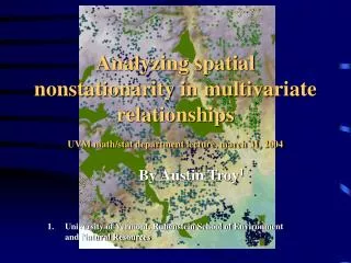
Spatial relationships between nutrition/activity indicators and built/natural environment measures in Iowa John DeGroote john.degroote@uni.edu UNI GeoTREE Center April 3, 2013
UNI GeoTREE Center • GeoInformatics Training, Research, Education, and Extension Center • Support the use of geospatial (GIS, RS, GPS, web mapping) technologies at UNI and throughout Iowa • www.geotree.uni.edu • john.degroote@uni.edu
This Project • Funded by a small seed grant from UNI • Purpose - pilot project to investigate relationships between self-reported nutrition/activity and health related variables and environmental metrics derived using GIS
Project goals • Develop a spatially referenced database on energy balance-related behavior, health outcomes, and environment • Examine patterns of Behavioral Risk Factor Surveillance System (BRFSS) survey results in Iowa • Development of spatial processing algorithms and models for deriving useful environmental metrics • Statistically investigate associations between derived environmental measures and behavior and health outcome data
Background • Proportion of population classified as overweight/obese has risen greatly nationally and in Iowa • Prevalence of adult obesity doubled between 1980 and 2002 while in children tripled (Ogden et al. 2006) • Iowa ranked 15th highest in nation on overweight/obesity prevalence among all 54 states/territories (IDPH, 2013)
Background • In Iowa 37% of adults considered overweight while 28% were considered obese based on 2007 Behavioral Risk Factor Surveillance System (BRFSS) (Centers for Disease Control and Prevention) • In a survey of 6200 7th and 8th graders in 2010-2011 19% and 18% were considered obese or overweight respectively
http://www.cdc.gov/healthyweight/assessing/bmi/adult_bmi/index.htmlhttp://www.cdc.gov/healthyweight/assessing/bmi/adult_bmi/index.html
http://www.idph.state.ia.us/iowansfitforlife/common/pdf/bmi.pdfhttp://www.idph.state.ia.us/iowansfitforlife/common/pdf/bmi.pdf
Background • There has been considerable research investigating relationship between environment and energy-related behaviors and outcomes • Often derived some environmental metric for comparison to some measure such as BMI
Background • Data often aggregated at some administrative unit such as zip-code or census tract • However, many have been somewhat piecemeal • Investigate one to several individual environmental variables in relation to some measure of obesity/overweight (e.g. BMI) • Recently more holistic environment studies
Methodology • Compile data on BRFSS and examine patterns in the state • Compile a variety of measures of environment related to both food availability and access to recreation • Examine associations between BRFSS averaged responses and environment measurements at various scales
Methodology • We hoped to estimate a variety of environmental measures for each estimated household in the state using proximity, neighborhood, and network analyses • A novel method which could potentially be used elsewhere • Estimate household locations using road network and population density by census block
Disaggregated estimated housing units in Iowa (population density by Census block – road network used to estimate housing units based on urban, urban cluster, and rural classifications
By modeling households we could hopefully avoid situations like this in which total number of fast food restaurants and grocery stores are aggregated to the census tract. In this example, there would be no difference between the two houses at the center of the buffers.
Thus we would be able to end up with more spatially precise estimates of the environment (top figure) that could be potentially investigated in relation to health indicators (e.g. BMI). Bottom figure would be an example of aggregated to census values. Also would be useful for targeting interventions.
BRFSS • Behavioral Risk Factor Surveillance System (BRFSS) • Phone survey of adults throughout Iowa • We obtained data from 2005-2010 (~30k responses) with zip-code and county of residence recorded • Questions about height & weight (BMI), fruit/veg consumption, general health, exercise, etc. • Only examine zip-codes with at least 20 responses
Environmental Measures • Derived a wide range of environmental metrics at county, zipcode, and household levels • Business data (restaurants, fast food, convenience stores, bars, fitness facilities) from InfoUSA • Calculate neighborhood statistics so for each location know how many businesses within a certain neighborhood • Recreational trail density • Land use mix – estimate of diversity of land uses
Environmental Measures • We have derived a wide range of environmental metrics at county, zipcode, and household levels • Area of recreational land use • Population and housing density (census block) • Network density • Average NDVI scores • Sprawl index • Slope
Grocery store density in Cedar Rapids (1 km neighborhood) Fast food density in Cedar Rapids (1 km neighborhood)
ZipCode Results • The general health, exercise and BMI all significantly associated • Higher income associated with better health, more exercise, and lower BMI • Larger average block size (sprawl index) associated with better health, more exercise, and lower BMI
ZipCode Results • More trails and higher trail density associated with better health, more exercise, and lower BMI • Higher grocery density actually associated with worse general health • Higher fast food density associated with more exercise and lower BMIs
Future Directions • Derive environmental metric scores averaged by households for comparison to BRFSS data • Need to proportion by urban, urban cluster, and rural household • Develop composite models of many environmental variables
Future Directions • Publish some of the research • Would be useful to have more geographically precise health measurements • Seek further funding for this
Conclusions • Demonstrated spatial variability in BMI and other variables in Iowa based on BRFSS • Developed a wide range of environmental metrics at different levels of aggregation • Results are preliminary • Still a lot of work to do to organize data properly for a systematicanalysis
Acknowledgements • Student Brian Swedberg did a lot of data processing • Iowa Department of Public Health (Don Shepherd) for providing BRFSS data • Disa Cornish UNI Center for Social Behavioral Research for consulting on BRFSS data
john.degroote@uni.edu Thank YOUQuestions?