Download
1 / 25
250 likes | 352 Views
Marie Venner, Venner Consulting AASHTO Maintenance Meeting July 19, 2011. GPS/AVL Technologies in Use at State DOTs. Research Trajectory on DOT GPS/AVL Use. 2004 AASHTO Compendium of Stewardship Practices in Construction & Maintenance

E N D
Marie Venner, Venner Consulting AASHTO Maintenance Meeting July 19, 2011 GPS/AVL Technologies in Use at State DOTs
Research Trajectory on DOT GPS/AVL Use • 2004 AASHTO Compendium of Stewardship Practices in Construction & Maintenance • 2005-2007 Research, TRB presentations and publications on DOT MQA tools and practices • 2011 Survey on GPS/AVL Use in DOTs with Erle Potter, VDOT • 33 States responded • Open-ended questions • Few states not using
DOTs’ Most Popular Hardware • IWAPI Weather Mgmt Data Collection - CO,WY, VA, ID (4) • InterFleet- OH, MO, KY,(3) • Location Technologies - IA, WA (2) • Force/Precise - WA, WY (2) • AmeriTrak’sAT500, AT300-NY, MN (2) • Network Fleet-VA, NM (2)
Less Common Hardware • Trimble/University of Minnesota/RFID Complete (AK) • Component Tech, Cirus, Network Fleet (DE) • CalAmps – LMU-5000 (MD) • LMU-700 for Contract Equipment (MD) • Intelligent Devices, Inc. (NE) • Compass Com (WY) • Pyramid Communications (VA) • XIRGO Technologies model XT-2000G IntelliPort (TN) • Fleetpoint (MO) • GeoDecisions division (PA) • WebTech, Product Link, JDLink (KY)
GPS/AVL Applications in Use • MDSS (CO, ID, KS, WY) (KS, NE - Meridian Env. Tech.) • Interfleet (MO, OH,KY) • In-house development underway (IA, WA) • RFID (AK) • Application supporting MDSS (NY) • Fleet tracking (IL - unspecified) • AVL – Acadian Mobile Monitoring (LA) • Telenav (MD) • AmeriTrak’s AT500 telematics system (MN) • WexSmart (MT) • Vision Link, JDLink (KY)
GPS/AVL Applications in Use - Continued • Skypatrol (NC) • Location Technologies (ND) • Custom software by Intelligent Devices (NE) • Networkfleet (NM) • GATIR-Geospatial Analysis of Threats and Incident Reports (PA) • LOCATE/IM – VANUS Group of Gannett-Fleming (TN)
Data DOTs Are Collecting and Finding Useful from AVL/GPS Systems • Operational/snow fighting efficiencies - speed, materials types and quantities, application rates, temperatures(DE, KS, KY, MD, MN, ND, NY, WA) • Vehicle location and route improvements/efficiencies (IL, KS, KY, NM, NY, WY) • Tracking units in extremely remote areas (NC, NM) • Road conditions over the state, near real time (WA) • Locations of incarcerated crews (MO) • History/daily achievements of sweeping crews (MO) • Contractor vehicle usage while “on the clock” (VA) • Photos, material used, application rate (NE) • Management data through Force/Precise system has been helpful (WY)
Data DOTs Are Collecting and Finding Useful from AVL/GPS Systems (cont.) • Location and vehicle bed load weight (AK, KY) • Mapped areas of noxious weed control (CO) • Forecasts to make informed decisions regarding striping, chip sealing, paving, and fog coating (CO) • Emergency patrol and snow and ice truck tracking (IL) • Maintenance Decision Support System (KS) • Motorist Assistance Patrol Unit applications (LA) • HELP Truck – Courtesy Patrol AVL (NM) • Windows Operating System, internet explorer (ND) • Location, track and trace, engine parameter data (VA)
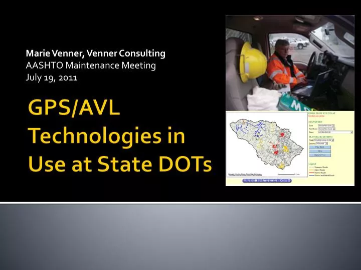
Data Collected, Used, DOTs Considered Purposes of AVL/GPS Systems, Continued… • Current, site-specific forecasts, and snow & ice control recommendations to snow plows • Pavement and air temperature, weather radar, forecasts, and treatment recommendations to plow operator • Material and rate – two-way monitoring, plus weather radars, forecasts, and treatment recommendations to plow operator • Operator can enter current road and weather conditions to MDSS • Camera captures images for display in MDSS. Camera images can be viewed on touch-screen • Pavement temperatures, plow up/down, auger status, spinner rate, etc. • Customized operations summary reports with info for each plow truck (material usage and mileage totals)
Other Things DOTs Would Like:CAN Bus Data Some DOTs Want to Acquire • Atmospheric pressure • Wiper status • Headlight status • Sun sensor • Accelerometer • Impact sensor • Steering angle • Anti-lock braking system status • Vehicle error codes • Idle time • Streaming video • Road conditions in front of the plow truck • Material coming out of the spreader • Back of the plow truck to aid in backing and alerting the operator of vehicles, obstacles, pedestrians, etc. that may otherwise be hidden from view
Who is Using the Data? • Incident Command/Transportation Management Center Operations (LA, PA, TN, VA, WY) • DOT as a whole (MD, ND, NE,KY), management & supervisors (IL, NY), three highway divisions (NC) • Fleet Equipment Bureau staff (MT, NC, PA) • Maintenance Managers, Engineers, Crew Supervisors, Sweeping Crew Managers (MO, VA) • Snow & Ice Operations Managers (OH) • Dispatch (IL, NM) • Meridian Environmental Technology, MDSS vendor (KS) • Director of Asset Management (NC) • Maintenance crews using MDSS and the maintenance crew using the Force/Precise system. (WY) • One District viewing data for material usage on a pilot and our MDSS Pilot Program (ID)
Most Common Problems Encountered • Lack of adequate cell/data coverage, dead spots (IA,KS,MN,NC,NM,NY,WY) • Software malfunctions (operator, power supply, accuracy readings, device durability) (AK,IA,IL,MN,NE, OH,LA) • Software compatibility issues (ID,NY, KY) or other installation problems (CT,ND) • User interface-software (learning) (DE,KS,VA) • Hardware problems (ND, WA) e.g., mobile data computer hard drives corrupt (ND) or GPS antenna failures (WA) • Perception (SC) • Cost (CO)
Installation Issues Hardware • Bad power boards, computers or antennas. Touch screens initially not working, or failing shortly. • Differences among generations of hardware. • Size of unit and secure mounting in appropriate locations, location of GPS module in vehicle. Space for safe sensor and equipment mounting in vehicles is at a premium, especially when one needs to consider carrying passengers in a vehicle. People & Scheduling • Installations by many different people statewide – difficulties maintaining installation consistencies. • Vendor lack of involvement in recent installations. • Scheduling of installation - install units prior to the winter season!
Installation Issues continued • Some said truck electronics are more sophisticated and some devices have not kept pace • Installation problems were not ubiquitous though… • NM: Third party installed – no problems • NY: Tampering was an early issue. Vendor developed a tamper proof box • PA: Integration of AVL with statewide 800MHZ radio system • WA: Both vendor installed and agency installed has worked out very well
Sensor Compatibility Issues: DOTs Would Like Plug & Play • Would like all controls for sanders, liquid distributors, and plows to be plug and play rather than custom fit for each application • Very few ambient/road temperature sensors to choose from • Spreader controller integration has been biggest challenge • System bought as an aftermarket package • Age of unit: with 1996 and new cars and light trucks (TN); e.g., No compatibility issues except for older controller units (Dickeyjohn ICS 2000). Relocated units to trucks with Dickeyjohn Control Point controller units (NY) • Vendor coordination or support • Unwilling to invest much time to assist in solving problems • Sensor compatibility is an area where WSDOT had to work closely with vendors to provide the right sensors for a given truck. More standardization would be helpful!
Compatibility Needs and Advice, Standardizing the Data Flow • Some DOTs noted that compatibility with other GPS/AVL systems is not an issue, but rather: • The key is standardizing the data flow to the system. • Requirements are highly variable within programs of DOT. Careful thought needs to be given to this and how to integrate the data into various applications. • Configuring and reading the data from the spreader controllers is an issue. • Standard protocols should be developed and followed so that different devices will plug and play. • This is a struggle, similar to the RWIS concerns of the late 1980s/early 1990s. • Some challenges with older hardware connections into newer devices, i.e., serial connections, etc.
Retrieving Data from GPS/AVL/Telematics Systems • Many have had few/no problems (IL, MN, NE, NY, PA, TN) • Software, hardware, and communication issues… • Issues using the air cards to transmit the data (IA) • Latency and refresh issues – likely software (NM) • Unable to access software due to (KY, now resolved) • Generating useful reports • Still working on getting all the data needed from the material spreader and sorting the data out to make consistent reliable reports of the data (MN) • Would prefer to be able to customize our own reports. Many reports the DOT requested came at an additional cost (MO) • WSDOT now requires the raw data from the truck or they will not use that AVL vendor • WYDOT says some are difficult, some are easy. Difficulties exist with internal networks, not just with vendor stored/provided information
Solutions Under Consideration by State DOTs • More differential GPS • Increase GPS/AVL capability to expand MDSS program statewide • Define long-term business requirements • Post processing of data from material spreader • Reduce salt usage & utilize contract trucks • Provide preventative maintenance schedules and fuel utilization • More research, via AASHTO or NCHRP
Hardware Solutions Under Consideration • New sensors • Hard wiring the interface cable to the hydraulic controller boxes or changing the connection type on the cable • Adding multi-sensor input from vehicle peripheral equipment such as snow plow blade position, spreaders, weather and road condition sensors
Software-Related Solutions DOTs Are Considering • Choosing certain systems/versions and not others • Re-evaluating the current contract and possibly putting out a new RFP • Using systems with which they haven’t encountered problems or that plug into new spreader controls • Either a newer release of the software or new sensors
Needs Identified by DOTs • One standard platform that works with all transportation vehicles • Creating standard specifications to ensure collected data is consistent; e.g., data output from on-board systems becomes the property of the using agency, can be shared and exportable to agency GIS systems • Inventory control • Cost benefit analysis/application types • Compatibility of instrumentation • Automated fuel system – including vehicle ID, employee ID, and vehicle/equipment meter reading • General research; e.g., impact of solar flares on GPS communication
Operator Interface Needs/Solutions • Speech recognition response back from driver so driver does not have to take as much attention off driving • Utilize tablet PCs or smart phones as the operator interface. Cable connects to OBDII and other monitored/controlled systems, single wire CAN bus, or, even better, in-vehicle wireless interface to these items • All other paperwork and system access/interface the vehicle or equipment operator needs (time card, traffic signal software, maintenance work order software, construction project software, bridge monitoring, engineering, etc.) • Personnel detection to reduce employee injury/death
Plans to Acquire or Develop GPS/AVL • No current plans to acquire (other) GPS/AVL technology (CO, CT, IL, NC,NM, SC, TN) • Gathering information, looking for cost-benefit (CT,ND,NY, PA, WY, ND) • Not sure/to be determined (ID,MO, PA) • Will purchase more units if the pilot goes as planned (IA) • Build applications in house (IA, WA) • Purchase radar and precipitation sensors (MN) • Locate IM – VANUS / Gannett Fleming (LA)
Specific Software DOTs Have Plans to Acquire • Trimble in conjunction with a mobile weather detection system (AK) • Component Tech / Cirus (DE) • Road/Air temperature, and Relative Humidity sensors from Vaisala(MN) • Trimble/University of Minnesota and RFID (AK) • Network Fleet (VA) • Force/Precise, Location Technologies (WY) • Intelligent Devices Inc - future MDSS applications (ID) • AmeriTrak (MN) • HELP Truck – Courtesy Patrol AVL (NY)
State DOTs Looking for the Following Hardware or Applications • Application to translate the many data points into management-level data for asset management system, yet maintain sufficient granularity for certain aspects of the operation (WY) • Collect mobile weather data in areas where forecasting is sparse using IR, ambient temperature sensors and participation sensors. (AK) • Hardware to collect data from vehicle’s Controller Area Network (CAN) Bus (MN) • Relative humidity and precipitation readings from sensors on plow truck, road friction (traction) from sensors on ½ ton Ford and Chevrolet pickups (MN) • Streaming video from plow truck (MN) • AVL for MAP units (LA)


![[Storage]](https://cdn3.slideserve.com/5804430/slide1-dt.jpg)