Download
1 / 25
250 likes | 408 Views
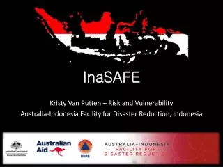
InaSAFE Kristy Van Putten – Risk and Vulnerability Australia-Indonesia Facility for Disaster Reduction, Indonesia. Content. What is AIFDR? InaSAFE Introduction Mentawai Example Tsunami Inundation OpenStreetMap data collection Population InaSAFE Results InaSAFE package.

E N D
InaSAFE Kristy Van Putten – Risk and Vulnerability Australia-Indonesia Facility for Disaster Reduction, Indonesia
Content • What is AIFDR? • InaSAFE Introduction • Mentawai Example • Tsunami Inundation • OpenStreetMap data collection • Population • InaSAFE Results • InaSAFE package
Australia-Indonesia Facility forDisaster Reduction (AIFDR) 2008: Agreement to form a joint initiative between the governments of Australia and Indonesia 15th July 2010 AIFDR was launched AIFDR is a partnership between AusAID and Indonesia's Disaster Management Agency (BNPB) AIFDR is designed to strengthen Indonesia's ability to reduce the impact of disasters
AIM To uses Australian and Indonesian science and data to better identify natural disaster hazards and risks in Indonesia. To build Indonesia’s capacity to self-manage disasters To works in partnership with BNPB and with key community sector organisations (CSOs) and non-government organisations (NGOs) to ensure vulnerable communities are better prepared for disasters. To shared the outcomes with the region through partnerships with ASEAN and the United Nations
Content • What is AIFDR? • InaSAFE Introduction • Mentawai Example • Tsunami Inundation • OpenStreetMap data collection • Population • InaSAFE Results • InaSAFE package
Content • What is AIFDR? • InaSAFE Introduction • Mentawai Example • Tsunami Inundation • OpenStreetMap data collection • Population • InaSAFE Results • InaSAFE Package
Request for Assistance 1. Support an international disaster response exercise 2. Define evacuation zones and planning at the local level
Developing the hazard Model: Probability of Inundation West coast East coast
OpenStreetMap in Indonesia • Free Map of the World • Everyone is able to edit the information • Online, desktop and Mobile applications • Open Licenses • Can assist Indonesia to “fill the gaps” www.openstreetmap.org
OpenStreetMap in Indonesia • Insert OSM movie
OpenStreetMap in the Mentawai Problem: Did not have high resolution Imagery for all of the of Mentawai • Imagery – US Government • Digitize in OpenStreetMap • Populate with Attribution 145,000 Buildings were mapped across the mentawai
InaSAFE Question Apabilaterjadi:
Population • Using Government of Indonesia boundaries • Population from BupatiMentawai • Settlement area from analysis of OSM buildings • AIFDR created a population count per 25m
InaSAFE Question Apabilaterjadi:
InaSAFE Results 17,000 people are within 50cm of water and need evacuating 297,000L 1,780,000L 850 3,400 47,600kg
InaSAFE Didukungoleh: