Download
1 / 21
220 likes | 314 Views
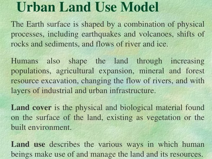
Urban Land Use Model. The Earth surface is shaped by a combination of physical processes, including earthquakes and volcanoes, shifts of rocks and sediments, and flows of river and ice.

E N D
Urban Land Use Model The Earth surface is shaped by a combination of physical processes, including earthquakes and volcanoes, shifts of rocks and sediments, and flows of river and ice. Humans also shape the land through increasing populations, agricultural expansion, mineral and forest resource excavation, changing the flow of rivers, and with layers of industrial and urban infrastructure. Land cover is the physical and biological material found on the surface of the land, existing as vegetation or the built environment. Land use describes the various ways in which human beings make use of and manage the land and its resources.
Urban Land Use Model Early in the 19th century Von Thünen developed a theoretical model that describes how market processes determine local land-use patterns. Johann Heinrich von Thünen (1783-1850) was a skilled farmer who was knowledgeable in economics. His model was created before the first large-scale industrialization and is simplest explained in terms of agricultural land use around a central market city.
1826 AD “Isolated State” • Applied in the case of Germany • The theory was introduced before industrialization • The Theory is combination of his two models: • Intensity theory • Crop theory
Assumptions The central city is located centrally within an "Isolated State" which is self-sufficient and has no external influences. (Unoccupied wilderness) The Isolated State is surrounded by an unoccupied wilderness. The land of the state is completely flat and has no rivers or mountains to interrupt the terrain. The soil quality and climate are consistent throughout the State.
Farmers in the Isolated State transport their own goods to market via oxcart, across land, directly to the central city. Transport costs thus rise linearly with distance. The selling price for the agricultural products is determined at the market by supply and demand (perfect competitive market) Farmers act to maximize profits (Rational Farmer) Equal wage rate all over the region
7 6 5 4 3 2 1
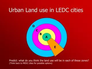
1. Central City 2. Dairying and intensive farming occur in the ring closest to the city. The related products (vegetables, fruit, milk and other dairy products) have the highest profits, but also the highest transportation costs because they are vulnerable and perishable. 3. Forest: Timber and firewood will be produced for fuel and building materials in the second zone. Before industrialization (and coal power), wood was a very important fuel for heating and cooking and construction material.
Wood is very heavy and therefore difficult and costly to transport. 4. Intensive Crop Farming:such as grain for bread. Crop rotation is practiced here. Since grain lasts longer than dairy products and is much lighter than wood transport costs are considered to be lower, allowing a location further from the city. 5.Crop Farming Fallow (seven in one): due to increasing tranportation cost and static labour cost, farmer prefer to leave one year fallow in seven years.
6. Crop Farming (three in one): the intensity of land use declines as it lies far from the central city to transport goods. 7. Ranching/Animal Product: It is located in the final ring surrounding the central city. Animals can be raised far from the city because they are self-transporting and thus have low transport costs. Beyond the ring lies the unoccupied wilderness, which is too great a distance from the central city for any types of agricultural product.
The economic rationale behind the model is described in terms of profit and distance from the market. The profit consists of the (fixed) selling price minus the (fixed) production costs minus the (variable) transportation costs. The transportation costs increase linearly with distance. Profit = sell – (production cost + transportation cost)
Originally Von Thünen’s model was only concerned with location. However, it is possible to derive the land rent from this model. The farmers that grow a particular product prefer to locate closer to the city, as their profit will be higher. Thus for land closer to the city, they are willing to pay a rent, the land rent, which is at most the profit they make at that location.
Rent Transport cost T. Cost/ Rent Distance
The model compares the relationships between production cost, the market price and the transportation cost of an agriculture commodity. The conclusion is that land closer to the city will have a higher price than land that is located further from the city. In this simplified approach he states that land rent at a location will be equal to the local profit, being defined as:
R = Y * (P-Cp) – Y * ( Ct * d), in which: R = land rent ( $/acre) Y = yield (ton/acre) P = market price ($/ton) Cp = production cost ($/ton) Ct = transportation cost ($/ton/miles) d = distance from town (miles)
Why this theory is important Even though the Von Thünen model was created in a time before factories, highways, and even railroads, it is still an important model in land use planning. The Von Thünen model is an excellent illustration of the balance between land cost and transportation costs. The farmers of the Isolated State balance the cost of transportation and land versus profit and produce the most cost-effective product for the market.
Von Thunen model highlights the importance of situation rather than that of site conditions. • Main idea (again): • Identical plots of land (site) may be used for different purposes depending on their accessibility to the market (situation) • Geographical difference may emerge even in the absence of initial variation in space
The original simplifying assumption of a homogeneous “featureless” plane in which the • central city is located received a lot of criticism. Many deemed the resulting concentric landuse patterns as being much too simple. • The model can however easily be adopted to include roads and rivers that might decrease transportation costs to some locations.
FACTORS THAT COMPLICATE URBAN LAND USE PATTERNS • Placement of roads and transportation arteries • Density of public transit systems • Cities have a horizontal and vertical dimension; various functions may intermingle • Natural geographical features may limit and attract urban development • Desire for social distancing/congregation between ethnic groups may produce ghettos/enclaves • Land use regulations and restrictions
Criticism • Multiple center may emerge • Different production has different transportation cost • Peculiarity of land (Land suitability) is not considered • Other Geographical factors besides distance may work • This model has neglected non-economic factors that affect land use factor • Almost none of the regions are isolated in this world today.
Introduction of bottling, canning and refrigeration technology has not limited the dairying and perishable good to near by center. • Too simple • Finally, the theory is too old and difficult to directly implicate in any region of the country, its basic idea is very important in rural urban linkage development.