Download
1 / 1
10 likes | 177 Views
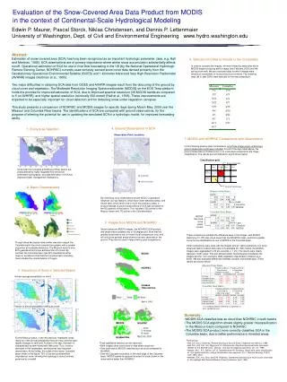
Missouri River Basin. Error of Omission. Less Cloud for MODIS. Columbia River Basin. MODIS has more snow pixels correct. MODIS. Less Cloud for MODIS. Error of Commission. NOHRSC. Gridded Observations. April 4, 2000. MODIS. NOHRSC. March 30, 2000. Gridded Obs.

E N D
Missouri River Basin Error of Omission Less Cloud for MODIS Columbia River Basin MODIS has more snow pixels correct MODIS Less Cloud for MODIS Error of Commission NOHRSC Gridded Observations April 4, 2000 MODIS NOHRSC March 30, 2000 Gridded Obs. Evaluation of the Snow-Covered Area Data Product from MODIS in the context of Continental-Scale Hydrological Modeling Edwin P. Maurer, Pascal Storck, Niklas Christensen, and Dennis P. Lettenmaier University of Washington, Dept. of Civil and Environmental Engineering www.hydro.washington.edu Abstract: Estimation of snow-covered area (SCA) has long been recognized as an important hydrologic parameter. (see, e.g. Hall and Martinec, 1985). SCA observations are of primary importance where winter snow accumulation substantially affects runoff. Operational estimation of SCA for use in river flow forecasting in the US (by the National Operational Hydrologic Remote Sensing Center, NOHRSC) currently uses remotely sensed snow cover data derived primarily from the Geostationary Operational Environmental Satellite (GOES) and 1-kilometer Advanced Very High Resolution Radiometer (AVHRR) images (Hartman et al., 1995). Two major difficulties in obtaining SCA data from GOES and AVHRR images result from the obscuring of the ground by cloud cover and vegetation. The Moderate Resolution Imaging Spectroradiometer (MODIS) on the EOS Terra platform holds the promise for improved estimation of SCA, due to improved spectral resolution (36 MODIS bands as compared to 5 on AVHRR), and higher spatial resolution (nominally 500-meter) (Hall et al., 1998). These improvements are expected to be especially important for cloud detection and for detecting snow under vegetation canopies. This study presents a comparison of NOHRSC and MODIS images for specific days during March-May, 2000 over the Missouri and Columbia River basins. The identifications of SCA are compared with ground observations, for the purpose of inferring the potential for use in updating the simulated SCA in a hydrologic model, for improved forecasting ability. 6. Selection of Dates to Include in the Comparison In order to compare the images, we were limited by dates after which MODIS began producing earth images (late February, 2000) and the spring snow melt. We also excluded days for which images were missing or incomplete, or excessively cloud-covered. The following days (all in year 2000) were selected for the intercomparison: 4. Ground Observations of SCA 1. Study Area Selection Observation Point Locations 7. MODIS and NOHRSC Comparisons with Observations Missouri Columbia In the following pixel-by-pixel comparisons, only those image pixels containing a ground observation point were included. For all of the days listed above, the ground observations of either snow or no snow were compared to the image classification. The results are summarized in a grid shown below: Classification grid: Since both the Columbia and Missouri River basins are characterized by highly regulated flow and snow-dominated hydrographs, accurate estimation of SCA has important water management implications. 2. Basin Characteristics By combining snow observations at both NCDC Cooperative Observer (Co-op) Stations, which favor lower elevation areas, and Snotel sites, which tend to be in more mountainous areas, a broad coverage of ground observations of SCA was compiled for the US portions of the basins. This included 1325 points for the Missouri basin and 773 points in the Columbia basin. 5. Images from MODIS and NOHRSC Shown below are MODIS images, the NOHRSC SCA product, and observations gridded onto a 1/8 degree grid. Note that the gridded observations are for broad visual comparisons only, and will only show general areas where snow was observed on the ground. They are not used in later pixel-by-pixel comparisons. These comparisons validate the difference seen in the images, with MODIS classifying 10-15% less cloud cover than the NOHRSC maps, and that a greater correct snow identification occurs in MODIS in the Columbia basin. Initial comparisons were done with the images at their native resolutions, but since observed station location data were only available at ± 500 meters, the MODIS images were aggregated to 30 arc-seconds ( 1 km). The results were nearly identical in both cases. This also allowed direct intercomparisons between the images and the 1 km resolution UMD vegetation classification (Hansen et al., 2000). We also analyzed differences between cloudier and clearer days. These results are shown below: Though these two basins have similar elevation ranges, the Columbia basin has more complex topography, with a greater proportion at moderate elevations. The Missouri basin is over 80% grasslands and crops and less than 4% forest. By contrast, the Columbia basin has 62% classified as either forest or woodland. Note that the Columbia basin boundary here includes the coastal basins in Oregon. Missouri River Basin 3. Importance of Snow in Selected Basins Annual average precipitation in mm/d Columbia River Basin Fraction of annual precipitation falling as snow Red shading indicates difference is significant at 95% confidence level • Summary: • MODIS SCA classifies less as cloud than NOHRSC in both basins • The MODIS SCA algorithm shows slightly greater misclassification in the Missouri basin compared to NOHRSC • The MODIS SCA product more correctly classifies SCA in the Columbia basin, due to better performance in forested areas. For the Missouri basin, in the mountainous headwater areas nearly all of the annual precipitation falls as snow, and the basin rapidly changes to semi-arid. Further to the east, the basin is characterized as semi-humid with little snow. Thus, snow is dominant in the headwaters, and becomes less important downstream. At the Dalles, the outlet of the interior Columbia basin shown in the figure, 70% of the annual streamflow originates as snow, showing the hydrology is almost entirely governed by snowfall. • References: • Hall, D.K. and J. Martinec, Remote Sensing of Ice and Snow, Chapman and Hall Ltd., 1985 • Hall, D.K., A.B. Tait, G.A. Riggs and V.V. Solomonson, Algorithm theoretical basis document (ATBD) for the MODIS snow-, lake ice-, and sea ice-mapping algorithms, ver. 4.0, 1998 • Hansen, M.C., R.S. Defries, J.R.G. Townshend and R. Sohlberg, Global land cover classification at 1 km spatial resolution using a classification tree approach, Int. J. Remote Sensing, 21(6/7), 1331-1364, 2000 • Hartman, R.K., A.A. Rost, and D.M. Anderson, Operational processing of multi-source snow data, In: Proceedings 63rd Annual Western Snow Conference, April, 1995 • Three qualitative features can be observed: • Both images show snow more-or-less where observed • Over both basins, MODIS classifies less as cloud compared to NOHRSC • Over the Cascade mountains, to the west edge of the Columbia basin, MODIS seems to capture the extent of snow shown in the observations better than NOHRSC