Download
1 / 21
240 likes | 521 Views
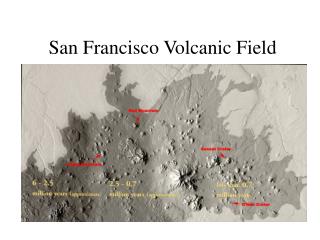
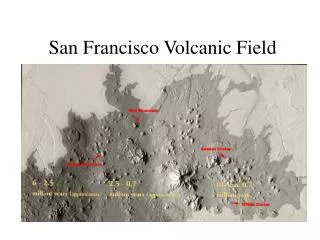
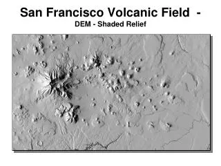
San Francisco Volcanic Field - DEM - Shaded Relief. Grand Canyon Stratigraphy. Timing of San Francisco Field Volcanism. Early basalts >6.0 Ma Bill Williams Mt. 4.2 to 3.6 Ma Mormon Mt. 3.1 Ma Sitgreaves Mt. 2.9 to 2.0 Ma Kendrick Peak 2.7 to 1.4 Ma Howard Mesa 2.1 Ma

E N D
Timing of San Francisco Field Volcanism Early basalts >6.0 Ma Bill Williams Mt. 4.2 to 3.6 Ma Mormon Mt. 3.1 Ma Sitgreaves Mt. 2.9 to 2.0 Ma Kendrick Peak 2.7 to 1.4 Ma Howard Mesa 2.1 Ma Hochderffer Hills 1.6 Ma Slate Mt. 1.5 Ma San Francisco Mt. 2.8 to <1.0 Ma O’Leary Peak 0.2 Ma Grand Falls 19,000 Years Saddle Mt. (V4626) <17,000 Years Sunset Crater 938 Years Next ? Total Volume: 1,485 km3 / 300 x 10-6 km3 yr-1
Basaltic ShieldsHouse Mtn., Verde Valley Mafic lavas – basalts Low silica / low viscosity High iron Quiet eruptions Gentle slopes Long lava flows Lava fountains Little explosive activity Often large caldera complexes
Stratovolcano or Composite ConeSan Francisco Peaks Mostly intermediate lavas Mod silica / mod viscosity Steep slopes & iconic cone shape High volatile content Explosive & effusive eruptions
San Francisco PeaksHumphreys, Agassiz, Fremont, Aubineau, Rees, Doyle Composite Stratovolcano Summit Elev: 12,633’ (3,850 m) Relief: 5,600’ (1,700 m) Volume: 26 mi3 (100 km3) Diameter: 4.6 mi (7.4 km) Lava domes, outward dipping lavas, tuff, and flow breccia. Shallow plutons and dikes. Rock Types: Largely andesite, also dacite, rhyodacite. Age: Early lava domes of North Sugarloaf 2.78 ± 0.13 Ma to 1.82 ± 0.16 Ma. Schultz Peak 0.75 ± 0.04 Ma.
Inner Basin FormationSan Francisco Peaks Missing volume: 1.9 mi3 (8.0 km3) <7% of total volcano volume. Debris forms series of flows to the east. Age: Younger than andesite flows on Humphrey’s Peak 0.43±0.03 Ma. Older than Sugarloaf 0.22±0.02 Ma. 430,000 to 220,000 years ago. Formation may be analogous to Mt. St. Helens.
Inner Basin FormationSan Francisco Peaks vs Mt. St. Helens • Reconstruction of original cone • Comparison between Mt. St. Helens & SF Peaks for eruptive style & caldera formation
DomesMt. Elden Silicic High silica / high viscosity Very steep slopes w/short, stubby lobate flows at S end Very viscous Intrusive and extrusive Valley Ten Thousand Smokes Long Valley CA
Mt. Elden Composite exogenous / endogenous lava domes. Summit Elevation: 9,299’ (2,834 m) Relief: 2,450’ (745 m) Volume: 1.7 mi3 (7 km3) Early Pelean-style ash eruptions. Bulbous flows that radiate from different centers. Locally intrusive. Northeast and northwest margin pushed up Paleozoic rocks. Rock Type: Dacite Age: 0.57±0.03 Ma to 0.49±0.06 Ma
O’Leary Peak / Darton Dome Composite Dome and Lavas. Summit Elev: 8,983’ (2,727 m) Relief: 1,938’ (591 m) Andesite porphyry flow, rhyodacite porphyry domes, and glassy rhyodacite flows and rhyolite domes. Rock Types: Rhyolite, dacite, and andesite. Age: 0.233 ± 0.037 Ma.
Cinder Cones and Maars Cinder Cones Pyroclastic eruptions Basaltic Composed of unconsolidated cinders, spatter Maar Explosive interaction of magma and water (phreatimagmatic) Little lava Tavurvur, Rabaul, Papau New Guinea Mt. Veniaminof Harrat Shamah Saudi Arabia
A-1 Mountain Scoria cone and associated lava flow. Summit Elev: 8,302’ (253 m) Relief: 702’ (214 m) Cone Diameter: 5,512’ (1,680 m) Summit Crater: 182’ (55 m) deep 1,181’ (360 m) wide Irregular, open to NW. Source of Observatory Mesa flow, 7.5 km long, steep margins, 60-90 m high. Rock Type: Benmorite (trachy-andesite) Age: 0.33 ± 0.08 Ma
A1 Mountain – Observatory Flow Lowell Obs.
Sunset Crater Scoria cone. Summit Elev: 7,979’ (2,432 m) Relief: 985’ (300 m) Diameter: 6,070’ (1,850 m) Summit Crater: 2,250 x 1,700’ (685 x 512 m) 400’ (121 m) deep Cone - loose, poorly sorted black cinder, fine ash and ejecta blocks. Rim capped by consolidated material colored by sulfur alteration. Additional flows and cones. Rock Type: Basalt (Bonito and Kana-a flows). 0.7 mi3 (0.3 km3) of magma erupted.
Sunset Crater Age: Tephra and early cone: 1064 - 1065 A.D. Kana-a flow: 1064 A.D. Cone building, Vent 512 flow Bonito flow: 1180 A.D. Black scoria, tephra, summit deposits. Vent 512: 1100 A.D. Gyp Crater: 1100 A.D. Eruptions lasted ~ 150 years.
Dry Lake – Colton Crater Maar Summit Elevation: 7,462’ (2,274 m) Cone Diameter: 7,480’ (2,280 m) Crater Depth: 442’ (135 m) Crater Diameter: 5,200’ (1,584 m) Ukinrek Alaska
Grand Falls – Little Colorado River • Lava flow formed dam ~20,000ybp • Merriam Crater is most likely source ~10km away • Lava flowed ~25km forming a downstream wedge • Sediment has filled the area upstream from the dam • LCR course changed to follow more easily eroded silt- and sandstones of the Moenkopi Fm.
Grand Falls – Little Colorado River Basalt Some pillow lava structure near base Analogous on a small scale to lava dams in the Grand Canyon