Download

1 / 15
150 likes | 249 Views
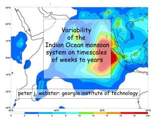
Building Disaster Resilient Communities Session 11: Understanding Hazards and Assessing Vulnerability. Steven P. French, Ph.D., AICP Georgia Institute of Technology. Q3 Flood Hazard Map. Estimated Intensity from a 7.0 R Magnitude Earthquake on the Hayward Fault Source: USGS.

E N D
Building Disaster Resilient CommunitiesSession 11: Understanding Hazards and Assessing Vulnerability Steven P. French, Ph.D., AICP Georgia Institute of Technology
Estimated Intensity from a 7.0 R Magnitude Earthquake on the Hayward Fault Source: USGS
Expected Ground Motion in the Mid-America PGA 0.20g 0.15g 0.10g
Parcel-Level GIS Database
Location of Hospitals in Mid-America
What is GIS? A system of hardware and software that links mapped objects to attribute information that describes them and provides tools to store retrieve and manipulate both types of data.
What is GIS? GIS Mapping/ Spatial Analysis Relational Database Essentially, a map tied to a database
Distributed GIS - Typical City Police Planning Building Inspection GIS Fire Public Works Elections Tax Assessor