Download
1 / 11
110 likes | 209 Views
Join us for a comprehensive workshop on seismic data management in Bogota. Learn about the seismic activity near Aruba, fault lines in the region, and the importance of seismology. Explore the newly established Meteorological Department in Aruba. Register now!

E N D
Data Management Workshop Bogota
Kingdom of the Netherlands • Dismantling of the Neth.Antilles and Meteorological Service Neth.Antilles & Aruba as of 101010 (Kingdom is now Neth, Aruba, Cur, St.Maarten) • Former branch MDNA&A on Aruba becomes DepartamentoMeteorologicodi Aruba as of 101010 • The Meteorological Department Aruba is now the source for Meteorological, Seismological and Climatological data for Aruba, as well as the official governmental entity to issue severe weather bulletins for Aruba. • Web-page http://www.meteo.aw
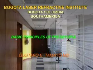
Neotectonic Map (Funvisis) • Pueblo Nuevo Fault on the Peninsula of Paraguana, lying about 50 km south from Aruba, has a seismic potential to generate an earthquake of magnitude 6.6 and a return period of some 2300 years. • Cuiza Fault NothwesternVenezuela and Northeastern Colombia, some 120 km southwest of Aruba, has a capability to generate an earthquake of 6.7, with a return period of 1500 years. • Eastern Oca Fault some 160 km south of Aruba and has a seismic potential to produce an earthquake of magnitude 7.5, with a return period of 390 years. The Eastern Oca Fault represents the highest seismic hazard for Aruba, because of its short return period and seismic potential.
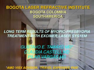
Minimum Mw = 8.7, 300 km x 200 km x 6 m slip (no slip since 1492) Mw 8.9 if 14 m slip 9.1<Mw<9.1 if both segments slip Mw=8.7 Mw=8.7
Seismic Stations Aruba Current Future
Type of Stations • CMG40T (30s-50hz), NETDAS (24bit) (prsn) • CMG3TD (120s-50hz), digitizer 24 bit (aruba) • CMG6TD (0.003hz-50hz), digitizer 24 bit (unesco)
Why Seismology on Aruba? • CaribeEWS • Recommendation FNVS 1997 • Citizens reporting ‘quakes’ • Citizens reporting ‘growing hill’ on eastward side • Great way to create science awareness