Download
1 / 4
40 likes | 70 Views
This planning session focuses on Skynet's trajectory follower, state estimation, terrain analysis, and path planning architecture. Discussion includes sensor integration, speed limits, reactive path evaluation, and simulation environment updates.

E N D
Planning Team February 28th, 2005 Lars Cremean, Dima Kogan, Adam Craig, Joe Donovan, Jeremy Gillula, Haomiao Huang, Laura Lindzey, Alex Stewart, Jason Yosinski, Ben Pickett, Sue Ann Hong, Ryan Cable
[edit] Discussion
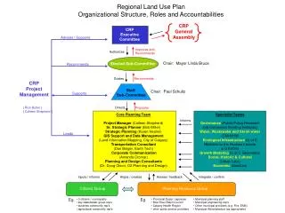
Embedded Relative to Winter W12 test Mode Management Path Planning Architecture/Status AS Trajectory Follower astate/skynet Terrain adrive (To All) State Estimation skynet Traj Steer, thr.,brake cmds. [RoadFinding] Sensors SAH ? Static Data [StaticInformer] Speed limit Gimbal cmds. (pitch, yaw) RC/HB For testing only HH RC RDDF Traj RDDF Path Gen. BP/JY DBS TSM skynetgui BP/JY CMap Mapping Modules JD Key AC [LadarFeeder] Traj Local DEM Layer(s) (To All) Traj TSM = Traj. speed modification Traj checking AC [StereoFeeder] DBS = “Speedsafety control” Reactive Path Evaluation/Selection DK Path Planning Conversion Owner Terrain cost/speed HELP! Needs work [RoadFinding] Road cost/speed Path Interface Combined Speed JD Working Map updates [StaticFiller] Static cost/speed Not yet HH HH Not ours RDDF Cost Update RDDF cost/speed Simulation Environment Vehicle Models BP/JY SkyNet msg. IG RT Map display Fri., 25 Feb. 2005
Major Issues • Need brakes and steering in final configuration by W12. • Need front workstations installed, to facilitate testing. • Need sensors mounted by W9. • Need to know whether we will have stereovision yaw control. • Getting the planner to be fully functional and accurate. • Integrating separate modules – many interfaces are still red on the status charts. Fri., 25 Feb. 2005