Download
1 / 15
160 likes | 293 Views
This document discusses the upcoming changes to the Unified Noah Land Surface Model within the Weather Research and Forecasting (WRF) system. Key updates include unifying the model physics across ARW and NMM codes, improving land surface parameters, and addressing subsurface flow routing with new parameters such as lateral Ksat and water table depth. Development plans for urban canopy models, coupling land-atmospheric interactions, and reassessment of surface layer schemes based on current research are also detailed, setting the stage for significant advancements in WRF's capabilities for the next major release.

E N D
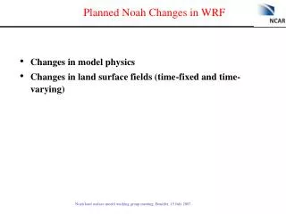
Planned Noah Changes in WRF • Changes in model physics • Changes in land surface fields (time-fixed and time-varying)
Unified Noah Land Surface Model in WRF • Goal: to have one single Noah code in both ARW and NMM WRF codes (to eliminate the option 99 in WRF/NMM code) • Unify or set options for different treatments of physics/parameters in two Noah codes used in ARW and NMM • The unified Noah for both ARW and NMM is almost ready to be implemented in the NCAR repository • Will it be the unified Noah V1.0? • Most likely ready in coupled WRF for the next major release (March 2008?)
Subsurface Flow Routing Noah-Router Future Development of Noah Land Surface Model (NCAR Tech Note: Gochis and Chen, 2003) • New Parameters: Lateral Ksat, n – exponential decay coefficient • Critical initialization value: water table depth • 8-layer soil model (2m – depth) • Quasi steady-state saturated flow model, 2-d (x-,y-configuration) • Exfiltration from fully-saturated soil columns Surface Exfiltration from Saturated Soil Columns Lateral Flow from Saturated Soil Layers Saturated Subsurface Routing Wigmosta et. al, 1994
Ball-Berry Scheme in GEM Jarvis scheme LAI – Leaf Area Index, F1 ~ f (amount of PAR) F2 ~ f(air temperature: heat stress) F3 ~ f(air humidity: dry air stress) F4 ~ f(soil moisture: dry soil stress) Fundamental difference: evapotranspiration as an ‘inevitable cost’ the foliage incurs during photosynthesis or carbon assimilation Ball-Berry scheme in GEM (Gas Exchange Model) hs – relative humidity at leaf surface ps – Surface atmospheric pressure An – net CO2 assimilation or photosynthesis rate Cs – CO2 concentration at leaf surface m and b are linear coeff based on gas exchange consideration An: three potentially limiting factors: 1. efficiency of the photosynthetic enzyme system 2. amount of PAR absorbed by leaf chlorophyll 3. capacity of the C3 and C4 vegetation to utilize the photosynthesis products
Future Development of Noah Land Surface Model • Ball-Berry photosynthesis-based canopy resistance (Niyogi, Kumar, Purdue U.) • Test in HRLDAS for 2001-2002 is nearly finished • Responses of canopy resistance to environmental and soil conditions are fairly different in Jarvis and GEM/photosynthesis formulations. • That leads to large differences in soil moisture and latent heat fluxes. • Incorporation of GEM in Noah is sensitive to description of land use (C3, C4 grass) and vegetation phenology (LAI, vegetation fraction, etc). GEM model reference: Niyogi, Alapaty, Raman, Chen, 2007: JAMC, in revision.
Future Development of Noah Land Surface Model • Multi-layer urban canopy model (Taha, Altostratus Inc; Borenstein, SJSU; Ching, EPA) • Has not yet started
The HRLDAS-simulated 2006 soil temperature and moisture were verified against Soil Climate Analysis Network (SCAN) data Locations of 68 SCAN sites
obs 6-layers Using 1-deg 2-m air T Averaged diurnal cycle over 6 SCAN stations in northeast domain
MODIS vs AVHRR Red: urban areas in the Pearl River Delta, China 1993 USGS data 2001 MODIS data
AVHRR MODIS Pearl River Delta, China Houston Water boundary mapping is different
New land/vegetation Products WRF-Noah land-use based LAI, 1 July 2006 • NESDIS 20-year climatology NDVI based products: • Monthly green vegetation fraction (GVF) • Monthly albedo • MODIS land products • 8-day and monthly LAI, GVF, emissivity, albedo • Monthly products • Real-time vegetation products • We are changing WRF Pre-prosessing System (WPS) infrastructures to handle these and future (realtime) land/vegetation data. MODIS based LAI, 1 July 2006
Fine-scale Urban Data Sets • Goal: Accommodate more complex urban models • National Urban Database with Access Portal Tool (NUDAPT) project led by Jason Ching of EPA • Plan • Consider these types of data are user specific and not to be included in WRF core data set? • However, WPS should enable an easy integration of these data. • change in WPS?
Link between land surface and atmospheric surface layer • Coupling between skin layer and first model level (depends on roughness lengths and wind speed) • Surface fluxes are more sensitive to the treatment of roughness length for heat/moisture than to M-O based surface layer schemes themselves Surface sensible heat flux Surface latent heat flux Surface exchange coefficient:
Link between land surface and atmospheric surface layer • WRF surface layer schemes • MM5 similarity: Based on Monin-Obukhov with Carslon-Boland viscous sub-layer and standard similarity functions from look-up tables. • Eta similarity: Used in Eta model. Based on Monin-Obukhov with Zilitinkevich thermal roughness length and standard similarity functions from look-up tables. • Need to evaluate these surface layer schemes, particularly WRT to nocturnal stable regime. Data sets for such evaluation? • Other schemes in consideration?