Download
1 / 6
60 likes | 218 Views
Explore the diverse landforms of North America, from the Eastern Lowlands to the Western Mountains, and discover the valuable water resources that sustain life on the continent. Learn about the various regions and their significance in shaping the landscape and providing essential resources.

E N D
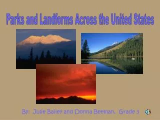
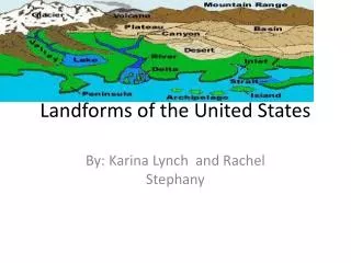
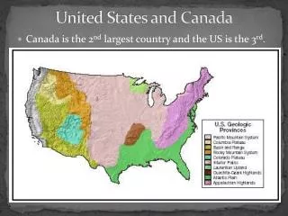
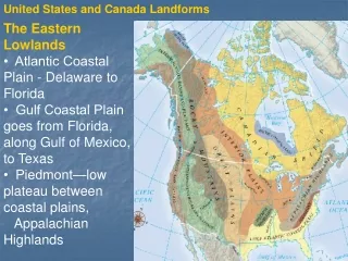
United States and Canada Landforms The Eastern Lowlands • Atlantic Coastal Plain - Delaware to Florida • Gulf Coastal Plain goes from Florida, along Gulf of Mexico, to Texas • Piedmont—low plateau between coastal plains, Appalachian Highlands Continued . . . NEXT
The Appalachian Highlands • Appalachian Highlands run 1,600 miles, stretching from SE Canada through the SE of the U.S., and are slowly eroding - includes the Green, Catskill, Blue Ridge and Great Smoky mountains 1 Continued . . . NEXT
The Interior Lowlands • Glaciers leveled the land, left fertile soil • Interior Plains extend from Appalachians to Missouri River • Great Plains extend from Missouri River to Rocky Mountains • Canadian Shield—vast, flat area around Hudson Bay Continued . . . NEXT
The Western Mountains, Plateaus, and Basins • Rocky Mountains run 3,000 miles from Alaska to New Mexico and are 80 million years old • Continents highest peak – Mt. Denali • Continental divide – Marks the separation between rivers flowing East and rivers flowing West Continued . . . NEXT
The Islands • Canada’s large, northern islands • U.S.: Aleutians (Alaska), Hawaiian 1 NEXT
Resources - Water •U.S. and Canada are bounded by: - Atlantic, Pacific, Arctic oceans and Gulf of Mexico • rivers and lakes that provide - transportation, hydroelectric power, irrigation, fresh water • Great Lakes: HOMES • Mississippi-Missouri-Ohio river system: continent’s longest, busiest river • Mackenzie River: longest in Canada Land and Forests • Fertile soil helps make North America world’s leading food exporter • Large forests yield lumber and other products NEXT