Download
1 / 32
320 likes | 339 Views
This document discusses the evaluation of T799 NR and new projects in Meso and Regional OSSE, including the simulation of radiance data and the joint OSSE Nature Run by ECMWF. It also provides information on accessing the data set and supplemental data.

E N D
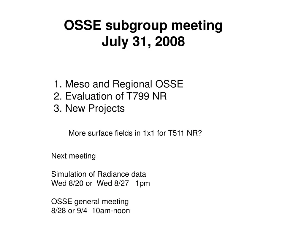
OSSE subgroup meeting July 31, 2008 • Meso and Regional OSSE • Evaluation of T799 NR • New Projects More surface fields in 1x1 for T511 NR? Next meeting Simulation of Radiance data Wed 8/20 or Wed 8/27 1pm OSSE general meeting 8/28 or 9/4 10am-noon
Joint OSSE Nature Runby ECMWF • Based on recommendations/requirements from JCSDA, NCEP, GMAO, GLA, SIVO, SWA, NESDIS, ESRL • “Low Resolution” Nature Run • Free-running T511 L91 w. 3-hourly dumps • May 12 2005 through June 1 2006 (13 mnth long) • Two “High Resolution” periods of 35 days each • Hurricane season: Starting at 12z September 27,2005, • Convective precipitation over CONUS: starting at 12Z April 10, 2006 • T799 L91 levels, one-hourly dump Initial condition from T511 NR
Archive and Distribution The Complete data set • saved at ECMWF, NCEP, ESRL, and NASA/GSFC • ECMWF: • Archived in the MARS system as expver=etwu • NASA/GSFC portal: • ID and password required • contact: Harper Prior (Harper.Pryor@nasa.gov) • Gradsdods access is available for T511 NR. The data can be down loaded in grib1, NetCDF, binary. The data can be retrieved globally or selected region. • Provide IP number to :Arlindo da Silva (Arlindo.Dasilva@nasa.gov) • NCEP: Require account at NCEP • Nature Runs are available to designated users for research purpose& users known to ECMWF • The user list outside of the EC is maintained by :Michiko Masutani (michiko.masutani@noaa.gov) and reported to ECMWF
Archive and Distribution Supplemental data Supplemental low resolution regular lat lon data 1degx1deg for T511 NR, 0.5degx0.5deg for T799 NR Pressure level data: 31 levels, Potential temperature level data: 315,330,350,370,530K Selected surface data for T511 NR: Convective precip, Large scale precip, MSLP,T2m,TD2m, U10,V10, HCC, LCC, MCC, TCC, Sfc Skin Temp Complete surface data for T799 NR Available from NCAR CISL Research Data Archive. Data set ID ds621.0 Currently NCAR account is required for access. (Also available from NCEP hpss, NASA/GSFC Portal, ESRL, NCAR/MMM, NRL/MRY, JMA, MSU, Utah) Note: This data must not be used for commercial purposes and re-distribution rights are not given.
MESO-Regional scale OSSE Discussion forum Forum_Meso_OSSE_080213.doc • Boundary condition for regional analysis • Regional NR add further uncertainty . Regional NR could divert from global NR • Regional OSSE for the best use of limited resources • Choice between WRF –var and GSI
GSI support Plan at DTC. • Ming Hu (NOAA/ESRL) • "DTC does have plan to release and support the use of GSI for communityusers. Here is a little details on the progress of the plan: • GSI has been installed on NCAR IBM and GSD linux cluster. • GSI is running well GSD Linux cluster • . GSI users guide is ready for NCEP and GSD to review. • DTC is planning to do GSI tutorial on January 2009.“
Namx Low resolution regional run template by Yochiaki Sato Vapor:/jcsda/save/wx23sy/Namx/Scripts.Base (cycle) Vapor:/jcsda/save/wx23sy/Namx/Scripts.GlbGes(GSI only) Vapor:/jcsda/save/wx23sy/Namx/llprep.sh Vapor:/jcsda/save/wx23sy/Namx/prep_exp.sh > ### copy tools ### > > 1. mkdir ${GPFS_VOLUME}/save/${USER}/Namx > 2. cd ${GPFS_VOLUME}/save/${USER}/Namx > 3. copy the attached files into ${GPFS_VOLUME}/save/${USER}/Namx > Original scripts are in HAZE:/jcsda/save/wx23sy/Namx > 4. gunzip -c Scripts.Base0829.tar.gz | tar xvf - > > ### modify the baseline script ### > > 7. edit llprep.sh > # please change lord leveler parameters for your account: > # account_no, class, group, and gpfs volume name > 8. run the script (sh llprep.sh) > > ### set experiment environment ### > > 9. edit prep_exp.sh > # please configure your experiment > # EXP_NAME, VOL_NAME, S_DATE, E_DATE > 0. run the script (sh prep_exp.sh) >
Resource requirement T382 one node GSI 4 hour/day (4 cycle) one 5 day forecast: 2.5 hour ? 4 cycle per day, 5 day fcst twice a day: with one nodes 9 hr/day T126 2 node GSI 40min/day (4 cycle) one 5day fcst 10min 4 cycle per day, 5 day fcst twice a day: with 2node 1hr/day GOES-R 20km 10 times thining -> 60 km resolution : 15MB/hr 360MB/day=150GB 20km resolution 3.6GB/day=1.5 TB/year 4lm resolution 3.6x25=90GB/day=33TB/year
April 2008 An Observing System Simulation Experiment to Evaluate ATMS and CrIS Observations Christopher M. Hill Patrick J. Fitzpatrick Valentine G. Anantharaj Mississippi State University Lars-Peter Riishojgaard Global Modeling and Assimilation Office / NASA Joint Center for Satellite Data Assimilation MSU_2008Apr_OSSE-plan.080410.ppt
Squall line / cold front case event from T799 NR Mississippi State University Hill_MSU_case_event_T799_080731.ppt
MSU OSSE update • Investigating GSI and WRF-VAR for assimilation of synthetic observations • ATMS (and later CrIS) radiance simulation by NESDIS • Conducting baseline MM5 simulation • T799 data serve as initial conditions and boundary conditions • 9-km and 3-km domains • will attempt to extract synthetic observations (i.e. RAOB, SFC)
Evaluation of Tropics in T511 Oreste Reale Reale_Evaluation_ECMWF_T511NR.ppt • The NR shows a stronger than climatology TEJ, but a very credible and realistic decrease of easterly speed with the progress of the monsoon season. As a consequence, the environment becomes conducive to more development • First Nature Run to simulate one entire season • Twelve tropical cyclones develop • Realistic variability of tracks • Most intense reaches 957 hPa • Binary vortices, looping and singularities are observed (good from OSSE perspective)
Concluding remarks on the African Monson region and tropical Atlantic (T511NR) • A synoptic assessment of the NR over the AM region and the tropical Atlantic shows an overall very realistic African Monsoon, AEJ and wave activity • Several weak tropical and sub-tropical systems are present, together with `major’ tropical cyclones • In spite of a tendency of creating several early recurvers, it can be stated that the NR, given the resolution limitation, does have a very good representativeness of tropical cyclone track variability in the Atlantic, as it would occur in an active season • This Nature Run represents a very promising tool to perform OSSEs over the tropical Atlantic
Summary of Tropics of T799 NROreste Reale Reale_T799_October_Nature_Run.ppt • AEJ is 40% weaker than climatology • Atlantic TC activity contains some highly suspicious tracks • Eastern Pacific seems to present excessive proliferation of weak TCs • The intensity of the strongest ATL systems is not superior to T511 • Different behavior in different basins • Structure of some intense system not very satisfactory in terms of scale and size of eye-like feature
Preliminary conclusions • The increased resolution does not necessarily provide stronger confidence in a much better Nature Run for the tropics • Representation of TC activity does not immediately appear superior to the T511 • Caution should perhaps be used in adopting this NR for applications centered on future instruments targeting hurricanes • Further investigation is needed
Summary: Extratropical Cyclones 31R1 @ T511 (DJFM) Thomas Jung Jung_ECMWF_Nature_Run_TJ.ppt • Synoptic activity (extratropics): • Generally well represented • Distribution of storm frequency quite realistic • Problems in the Gulf Stream/Kurushio area? • Too many systems in the eastern Atlantic (blocking)
Summary: Tropical Cyclones 31R1 @ T511 (DJFM) • T511 model produces quite realistic frequency of occurrence of TS/Hurricanes in the Atlantic. • North African Monsoon too strong + northward shifted. • AEJ is too weak (problem at higher resolution). • Perhaps slightly too much AEW activity. • Strong problems in the western tropical Pacific (too little atmospheric upwelling). Problem larger at higher resolution.
Some Other Issues: Model Climate 31R1 @ T511 • Amplitude of the MJO is underestimated (better in recent cycles but still an issue). • Convectively coupled Kelvin waves in the tropics are underestimated (better from 32R3 onwards). • Too little (much) precipitation over the tropical continents (oceans) (improved in recent cycles). • No QBO • Euro-Atlantic blocking significantly underestimated (large improvements in 33R1). • Anti-cyclonic circulation bias in the North Pacific (fixed in 32R3)
Tropical Cyclones in Recent Model Cycles • Generally there is an increase in the number/intensity of tropical cyclones/hurricanes. • Particularly lower resolution versions perform better than older cycles (e.g., US landfall). • Large increases in the western tropical Pacific (partly due changes in the large-scale atmospheric circulation). Too large?
Sensitivity to Horizontal ResolutionThomas JungJung_ECMWF_Nature_Run_TJ.ppt • Short-range and medium-range forecasts suggest that T799, if anything, produces stronger hurricanes than T511. • Resolution studies, however, suggests, that some aspects of the tropical climate (i.e., beyond the medium-range) of 31R1 deteriorate when increasing horizontal resolution (T159->T511). So it may be possible that T799 performs worse than T511. • In the extratropics the largest changes occur when going from T95 to T159. Rather little changes occur beyond T159 (T159->T511). Hence, it seems reasonable to assume that T511 and T799 perform similar.
Colder surface in Both poles (T799NR) Michiko Masutani Masutani_T799_T511.080410.ppt Transient eddy kinetic energy become activs in SH toward summer Both Poles are colder in T799 NR 10 day average sfc skin temperature
Zonal mean high pass eddy KE at 250hPa Three day running mean subtracted Interpolated to 1degree 3 hour sampling Toward end of October, SH become erroneously active in T799 NR.
Arctic in T511 NRNikki Prive Prive_arctic_ice_080221.ppt • Stratospheric ‘cold pole’ - without input from obs, model develops abnormally cold polar region in winter with strong polar vortex. Common problem with global models. • Surface temperatures are strangely high over the arctic • Disconnect with temperatures above surface layer? • Low level inversion too weak - impacted by many processes • What is energy balance over ice? SHF/LHF/longwave/cloud impacts? • Sea ice and SST are applied from 2005/6 fields, not interactive with model atmosphere
Omega fields in Hurricane (T511 NR) Nikki Prive A mage from the storm that hits Florida, with the 850 mb omega in full colors (blue = up), and the 250 mb omega in red contours (solid lines = up) The upper level upward maximum seems to wobble around, displaced about one degree from the lower level area of strong vertical velocities. It doesn't really look like an artifact of the low resolution interpolation. I would have expected stronger stacking of the omega field - maybe this is not a problem, though? I haven't looked at the full reduced gaussian data yet because it is messy, and I'm certainly not any kind of expert on hurricanes....
Quick look using 1degree data Min MSLP T799 OCT05 period T511 T799 By Michiko Masutani
Quick look using 1degree data Convective Precipitation 3 hour mean 12z-15Z Oct05 2005 T511 T799 By Michiko Masutani
Quick look using 1degree data Min MSLP T799 APR06 period T511 T799 By Michiko Masutani
Convective Precipitation in Spring Quick look using 3 hour mean 1degree data T511 06Z Apr 25, 2006 T799 01Z May 2, 2005 By Michiko Masutani
Summary of the activities at the University of Utah Zhaoxia Pu, University of Utah ( Zhaoxia.Pu@utah.edu) • Evaluation of the ECMWF natural runs • 1. Winter storms in T511 • * 13 major storms are identified over the Northern American Area • * further Evaluation is in progress • 2. Hurricanes in both T511 and T799 • Regional OSSEs (Obs: DWL) • A few issues: 1) model and data assimilation systems • 2) boundary condition issues • 3) hurricane intensity (resolution and validation issues)
Yves J. Rochon Atmospheric Science and Technology Directorate Environment Canada My interest is essentially in conducting sensitivity analyses in data assimilation (currently global as oppose to regional). This work has only just begun. Am currently conducting an OSSE experiment consisting of (1) observation simulation using a nature run from our global model (set here for 120x240 horiz. resolution) and (2) conducting a few assimilations of this simulated dataset with and without one of the observation sources. The simulated obs consist of obs as used in weather forecasting (e.g. radiosondes, AMSU-A among others) plus a couple of additional stratospheric obs sources. For this first trial, the nature run is simply a model run covering 2.5 months and the assimilation uses this same model (realizing that this is far from the best choice but it's a first try) starting from different initial conditions than the model run. Will see what that gives. At some point in the future, I would like to take advantage of the nature runs to be made accessible from your joint OSSE program.
OSSE at Northrop Grumman Project Description: The primary objective of the effort is to provide NASA with the capability to quantitatively assess the benefits of observational data produced by proposed future observing systems. The research effort planned would look into extending the Sensor Web Simulation that NGIT is working on with NASA to incorporate a rigorous end-to-end simulation of future sensors and observing platforms, thereby allowing an accurate assessment of the impact of the operational data they produce on global weather forecasts. This supports the OSSE that NASA is pursing by allowing quantitatively-based decisions on the design and implementation of future observing systems. What NGST brings to this collaborative effort is EVEREST, the Environmental Product Verification and Remote Sensing Testbed. EVEREST is a "world-class" end-to-end modeling and simulation testbed for assessing the performance of remote sensing systems. Initially developed to establish the pre-launch performance of the NPOESS weather satellite system, EVEREST consists of comprehensive environmental scenes, databases and validated state-of-the-science models for physics-based phenomenology, radiative transfer, sensors, spacecraft, and data product retrieval. On the NPOESS program, EVEREST has been a critical element in allowing NGST and the government to predict the quality of the data products produced by the NPOESS sensor/spacecraft system, including the impact of changing sensor, spacecraft, algorithm and other system design parameters. It was also used during the PDRR phase of the GOES-R program to help establish system requirements for the program. It is currently being used to ensure that the as-built NPP/NPOESS system will perform as specified.